
Objectives of the service

The voluntary carbon market faces an integrity crisis. The challenge is not measuring trees on a project area; it is establishing a credible baseline, meaning what would have happened without the project. Today's baselines are typically chosen by the project developer or its consultants and have been criticised as subjective and unreliable, while predictive risk maps cannot adapt to political and economic shifts driving land-use change at scale.
belian.earth is building Carbon Market Certainty: independent, automatically-selected counterfactual baselines with quantified uncertainty. The Company's ramet5 platform uses geospatial artificial intelligence (geo-AI) trained on satellite data to identify the reference areas against which a project's impact is measured. These reference areas are independent of the project developer, reproducible by any auditor, and updated dynamically at every verification. The ramet47 variant was developed for Verra's VM0047 reforestation methodology.
The ESA Kickstart activity validated customer demand across project developers, conservation organisations, and sustainable timber companies; demonstrated the pipeline at jurisdictional scale across forest and coastal blue-carbon settings; and engaged in direct dialogue with Verra on methodological alignment.
Users and their needs
The activity targeted three user communities:
-
Project developers in the voluntary carbon market: companies originating forest conservation, restoration, and improved forest management projects under standards including Verra's VM0047, and VM0010.
-
Conservation organisations: non-governmental organisations operating reserves and restoration sites and reporting impact to philanthropic donors.
-
Sustainable timber companies: concessionaires demonstrating low-impact forestry against the default assumption that timber extraction is damaging.
User needs:
-
Independent reference areas not chosen by the project developer or its consultants
-
Reproducibility, so any auditor or standards body can re-run the analysis end-to-end
-
Quantified uncertainty on the baseline itself, where credibility is most contested
-
Adaptability across forest types, project methodologies, and non-carbon metrics
Users engaged during the kickstart included project developers operating in Sabah (Malaysia), Southern Africa, Latin America, and Southeast Asia; conservation organisations in Mexico and Colombia; and sustainable timber concessions. Validated by academic partners were the University of Aberdeen and the University of Exeter (UK). The ESA Kickstart co-partner was Bridge Carbon (UK), a project developer.
Service/ system concept
The system delivers reference areas (the comparison regions used to construct a project's baseline), biomass time series, and counterfactual estimates of what would have happened without the project. Outputs are produced automatically, are independent of the project developer, and can be regenerated by any auditor.
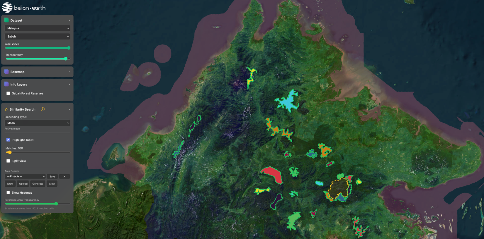
The platform takes a project boundary as input. Satellite data from European Space Agency Sentinel missions and NASA's Global Ecosystem Dynamics Investigation (GEDI) is processed by geospatial artificial intelligence models that summarise each location on Earth into a compact, comparable "fingerprint". The platform searches for areas with fingerprints similar to those inside the project boundary, then aggregates the matched cells into coherent reference regions, as illustrated for a fictional reforestation project in Southern Africa. Biomass change over time is then measured in both the project and the reference areas, and the difference quantifies the project's actual impact. The architecture has four components:
-
A web-based platform for customers to upload project boundaries and view outputs
-
An embeddings processing pipeline running on cloud infrastructure
-
An analytical layer that generates reference areas, biomass time series, and counterfactual estimates
-
An automated reporting layer for verification-ready outputs

Automatically-selected reference areas (colour gradient) matched to a fictional reforestation project in Southern Africa (pink). The colour scale represents how closely each reference area resembles the project area in land cover and biomass change over time. Image credit: belian.earth Ltd, Project : Conservation Integrity.
Space Added Value
The system uses optical and radar imagery from the European Space Agency's Sentinel-1 and Sentinel-2 missions, vegetation canopy structure from NASA's Global Ecosystem Dynamics Investigation (GEDI), and historic Landsat archive imagery. These data streams are combined through geospatial foundation models that distil multi-decade observation records into a compact "fingerprint" per location on Earth. The platform also integrates products from the European Space Agency's BIOMASS mission as these become available following the mission's 2025 launch.
Without space-based Earth observation at this scale, reference area selection for carbon and conservation baselines is performed manually by the project developer or its consultants. This approach is subjective, time-consuming, and structurally subject to potential bias because the developer chooses the comparison areas against which its own performance is measured. Predictive risk maps offer a partial alternative but cannot adapt to political or economic changes that drive land-use change at scale.
The combination of multi-mission satellite data and foundation-model embeddings enables automated, reproducible, and dynamic reference area selection at jurisdictional scale, removing the project developer from the loop entirely.
Current Status
The kickstart (November 2025 to May 2026) delivered an operational pipeline producing reference areas at jurisdictional scale, with throughput on the order of two hours per jurisdiction on cloud infrastructure. The platform was demonstrated across forest sites in Sabah (Malaysia) and Southern Africa and a coastal blue-carbon use case. The ramet47 variant was developed for Verra's VM0047 reforestation methodology. Engagement with Verra during the kickstart explored the approach, with no methodological barriers identified. One project consultancy contract was delivered; one conservation pilot offer and one VM0047 commercial dialogue are under active consideration. An academic placebo-validation paper is undergoing final polish for submission.
Work in progress includes application for Verra's Data Service Provider vetting (announcement May 2026). Activities preparing to begin include a Demonstration Project to scale validation.