

Objectives of the service
Smallholder farmers, who produce nearly a third of the world’s food, face increasing challenges from unpredictable weather, limited resources, and minimal access to insurance. Traditional crop insurance is often slow and costly because assessing crop losses requires time-intensive field visits, leaving farmers exposed to financial shocks and uncertainty.
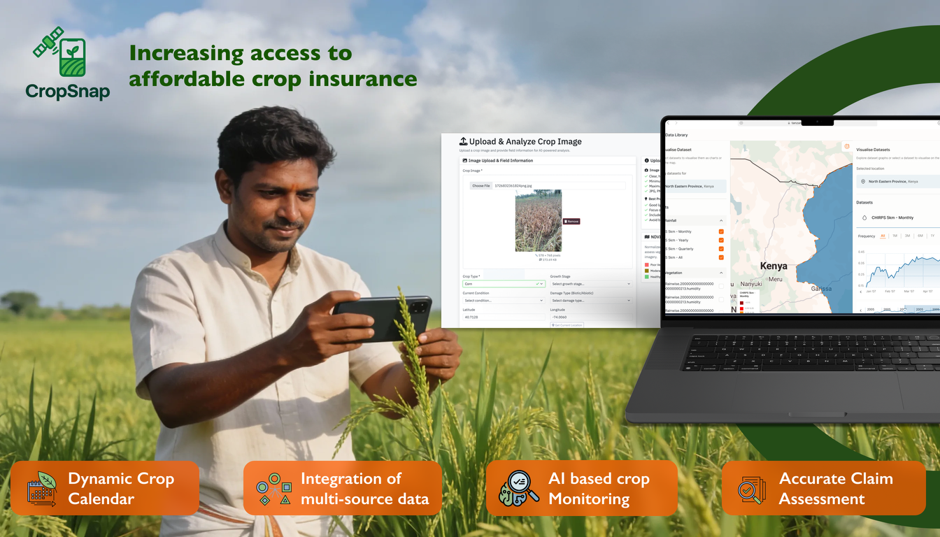
Agtuall’s service addresses this by offering a smartphone-based crop monitoring system that empowers farmers and insurers alike. Farmers are guided by an artificial intelligence–driven crop calendar, which prompts them to submit images at critical growth stages. These images are used to assess crop health and development, while machine learning determines the optimal timing for image collection based on local conditions. High-resolution smartphone images are combined with satellite data from Sentinel-2 and Sentinel-1 and local weather information to provide accurate, real-time insights.
By streamlining crop health assessment and loss verification, the service accelerates claim processing and enables insurers to offer more affordable, accessible insurance products. This supports farmers’ financial stability, enhances global food security, and strengthens resilience against environmental uncertainties, helping smallholder farmers thrive in an increasingly unpredictable agricultural landscape.
Users and their needs
The service targets multiple user communities in India, focusing on stakeholders in agriculture, insurance, and finance, with potential applicability in other smallholder farming countries and larger farm insurance and lending products in the future. Key users and their needs include:
Insurance Companies (Primary Segment)
- Needs: Accurate crop health evaluation, faster claims validation, continuous portfolio monitoring
- Challenges: Reducing assessment costs, improving loss accuracy, scaling operations efficiently
Loss Adjusters and Reinsurers
- Needs: Remote, cost-efficient, and accurate loss assessments; white-label solutions for clients
- Challenges: Ensuring reliability and standardization of remote assessments
Agricultural Banks & Financial Institutions
- Needs: Accurate crop monitoring for loan assessments, collateral verification, and risk management
- Challenges: Integrating data from multiple sources, timely risk evaluation
Agribusiness & Integrated Companies
- Needs: Traceability of produce, precision agriculture insights, digitized supply chains
- Challenges: Seamless technology integration and maintaining high-quality data
This activity involves these users actively in data collection, crop health assessment, and insurance or loan verification processes. Meeting their needs requires accurate, timely, and cost-effective crop monitoring solutions tailored to India, with the potential to expand to other countries and larger farm operations in the future.
Service/ system concept
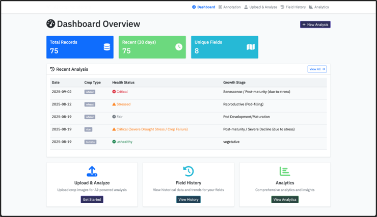
The service provides users with accurate, real-time crop health monitoring and damage assessments by combining on-the-ground photos from farmers, satellite imagery, and weather data. This process works in three simple steps. First, the system collects data from multiple sources: farmers submit geotagged photos via a mobile app, while the platform pulls in satellite and weather data. Next, an AI engine analyzes and fuses these data points to create a precise, stage-wise evaluation of crop health. If satellite data is obscured, the system prompts the farmer for additional photos, ensuring comprehensive coverage. Finally, the processed information is delivered to users through various channels: insurers access detailed reports on a web dashboard and via an API for their claims systems, and farmers receive instant notifications on their mobile app about the status of their crops and claims. This provides a transparent and efficient process for all stakeholders.

Space Added Value
The service leverages Earth observation data from Sentinel-2 and Sentinel-1 satellites, combined with high-resolution smartphone images and local weather information, to monitor crop health and assess losses. Sentinel-2 provides multispectral optical imagery that captures crop vigor, vegetation indices, and growth stages, while Sentinel-1 offers radar-based imagery, allowing crop monitoring even under cloudy conditions or during heavy rainfall.
By integrating satellite data with field-level smartphone images, we achieve a level of accuracy and timeliness that current methods cannot match. Existing competitors typically rely on either satellite data alone, which lacks fine-grained, on-the-ground detail, or image-based monitoring alone, which cannot provide consistent large-area coverage. Our unique combination of these space assets with local imagery allows for precise crop health assessment, optimized timing for data collection, faster loss verification, and more reliable risk evaluation.
This integration reduces assessment costs, accelerates claims processing, and enables insurers and lenders to offer more affordable and accessible products. Combining these space assets with ground-level observations creates a scalable, high-resolution monitoring system that improves accuracy and reliability compared to conventional or single-source methods, enhancing financial protection for smallholder farmers and strengthening agricultural resilience.
Current Status
Ongoing engagements with leading insurers in India through research, workshops, and prototype demos, validating demand and shaping service requirements.