Objectives of the service

The Climate Risk Reality
Droughts and wildfires are increasing in frequency, intensity, and unpredictability, which is challenging traditional insurance models and exposing clients to greater losses. Delayed claims, ambiguous coverage, and operational disruptions are no longer acceptable.
Our Solution: Parametric Insurance That Works
Our parametric insurance solutions offer pre-defined triggers and automated payouts—delivering speed, clarity, and confidence when it matters most.
- Pre-agreed triggers based on trusted climate and satellite data
- Rapid payouts, within days
- No adjusters. No delays. Just clean execution
- Customisable to your clients’ unique exposure
Insurers and Brokers Partner with Skyline
✅ Unlock new revenue streams with innovative risk products
✅ Complement traditional indemnity offerings
✅ Reduce basis risk through layered triggers
✅ Trusted by underwriters, backed by science
Users and their needs
The following customers / users will use Skyline’s technology platform for pricing, quoting, and administering parametric insurance products covering drought and wildfire risks with different motivations:
Reinsurers
-
Efficient response enabled by pre-underwritten risk models and technical pricing.
-
A “filter” already undertaken to ensure interest of the policy holder prior to the risk being presented for binding terms and work being undertaken to prepare a quote
Insurers
-
Reduced costs in underwriting and claims processing, enhancing overall profitability.
-
Elimination of conflicts of interest in claims assessment enhances trust and confidence among stakeholders.
Brokers
-
Rapid response capability (within hours) to client inquiries and needs.
-
Flexibility to offer multiple pricing options based on client preferences and risk structures.
-
Access to pre-structured products from capacity markets with integrated risk analysis and modelling.
-
Expedited claims processing ensures swift payments to clients’ post-event.
-
Independent product structuring reduces errors and legal risks, maximising value for clients.
Managing General Agents
-
Similar benefits as brokers in terms of rapid response, flexible pricing, and efficient claims management.
Corporates and Affinity Partners
-
Scalable execution of parametric insurance offerings across diverse markets.
-
Creation of new revenue streams through integrated insurance solutions.
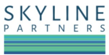
Service/ system concept
Custom-Built Drought & Wildfire Coverage backed by our Parametric Technology Platform
Skyline’s scalable parametric technology platform, can be white labelled for our partners to provide:
- Structuring, pricing, quoting and associated documentation (Quotes & Policy Wording)
- Claims calculations and claims notifications
Parametric Wildfire Insurance
- Triggers: Active fire detection, Fire Radiative Power, burn area thresholds
- Sectors: Utilities, real estate, critical infrastructure, governments
- Benefits: Fast cash injections post-event, no property damage validation required
- Data Sources: WFIGS, NASA FIRMS, EFFIS, VIIRS
Parametric Insurance Value Chain

Parametric Drought Insurance
- Triggers: Satellite-derived NDVI, soil moisture, rainfall deviation
- Sectors: Agriculture, forestry, utilities, sovereign risk
- Benefits: Predictable payout structures, no ground-level loss proof required
- Data Sources: Copernicus, NASA SMAP, CHIRPS, ECMWF
Space Added Value
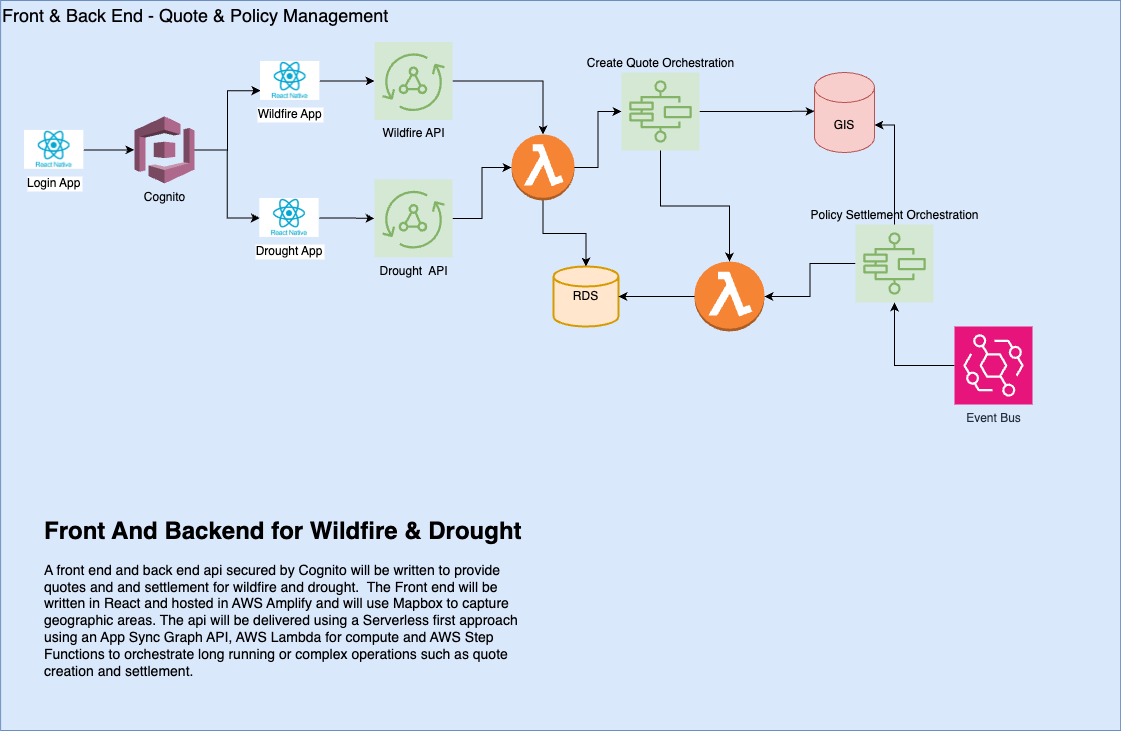
Data is key: For a parametric product to be successfully created and accepted by both the customer and insurer it is necessary to have a source of data for pricing and settlement purposes, well correlated to the financial impacts of the insured. In addition, it needs to be sourced from a trusted provider and be available soon after the event, as the data is used to identify an event and calculate the claim payment. Historical data also need to be available to enable risk modelling and actuarial pricing.
The rationale was that the space assets would serve specific purposes in enhancing parametric insurance capabilities:
- Enhanced Risk Assessment and Pricing.
- Enables precise and timely risk assessment and monitoring for wildfire and drought risks.
- Improved Claims Processing.
- Facilitates quicker and more accurate claims processing by providing near real-time data on disaster impacts.
- Customised Insurance Products.
- Allows for the development of tailored insurance products that meet the unique needs of different industries and regions.
- Global Coverage
- Provides comprehensive coverage globally, ensuring that the products can be offered in geographical areas where the risks are prevalent, US, Europe, Asia, Australasia, enabling the products to be scaled up globally.
The business rationale for the project was to address the following issues in the traditional insurance market with parametric insurance approach utilising space assets, focusing on wildfire and drought risks:
- Manual processes lead to delays in quotes, taking days or weeks.
- Inconsistent approaches cause confusion for clients and potential legal challenges.
- Products are not optimised for client needs or pricing, often leaving the client either over insured (paying more premiums than then need to) or under insured (not being covered for risks they should).
- Claims payments take months to process.
For Wildfire the candidate space asset sources were:
- MODIS (1km) & VIIRS (375m) active fire & burned area products. Near real time products readily available to identify fire activity in or near insured location (depending on insured location size)
- Sentinel-2: Can also be employed to estimate burned pixels resulting from wildfires. Finer resolution than MODIS and VIIRS but pipeline of derived products not readily available so requires further processing.
For Drought the candidate space asset sources were:
- ERA5 Land (European Centre for Medium-Range Weather Forecasts): Globally available consistent data set for land surface data. Resolution (c. 9km) potentially too coarse for some applications. Long history available for risk modelling and pricing. Modelled data for multiple levels in the soil profile allows for better modelling of drought risk.
- SMOS (Soil Moisture and Ocean Salinity) Microwave Satellite (ESA):Spatial resolution potentially too coarse for some applications. Shorter history than ERA5 Land.
- Spire’s GNSS-R (European Space Agency Third Party Mission):Fine resolution available for smaller insured areas. History of data back to 1978 allows for risk modelling & pricing.
Current Status
The EWPIP project implemented parametric insurance products using automated satellite data routines and index calculations for drought and wildfire risks. The project was to leverage a variety of space-based assets to enhance parametric insurance solutions for drought and wildfire risks with the objective to implement parametric insurance products efficiently on a global scale using automated satellite data routines and index calculations.
The data driven parametric wildfire and drought products supported by the technology platform developed for the EWPIP Project allows insurers, brokers and other insurance intermediaries to structure parametric products and receive indicative pricing, whilst improving insurance process efficiency, accuracy, transparency. The service also reduces claims payment time by simplifying complex parametric claims calculations utilising satellite data for drought and wildfire risks.
The aim of the parametric technology platform is to improve take up of parametric insurance by enabling better client and insurance market understanding and accessibility resulting in more parametric insurance premiums being generated utilising satellite data for:
- Speed and Efficiency: Skyline's proposed platform uses real-time satellite data for immediate and precise risk assessment, pricing and claims settlement.
- Automation and Scalability: Automation of the entire insurance lifecycle, from quote generation to claims processing. The solutions will be capable of handling thousands of risk locations globally, thanks to scalable technology.
- Standardisation and Consistency: Provide a consistent approach to structuring and managing parametric insurance drought and wildfire products.
- Client-Centric Solutions: Delivers customisable drought and wildfire products, tailored to meet specific client needs. Ensures maximum value and optimal coverage through quick adjustments and precise pricing.
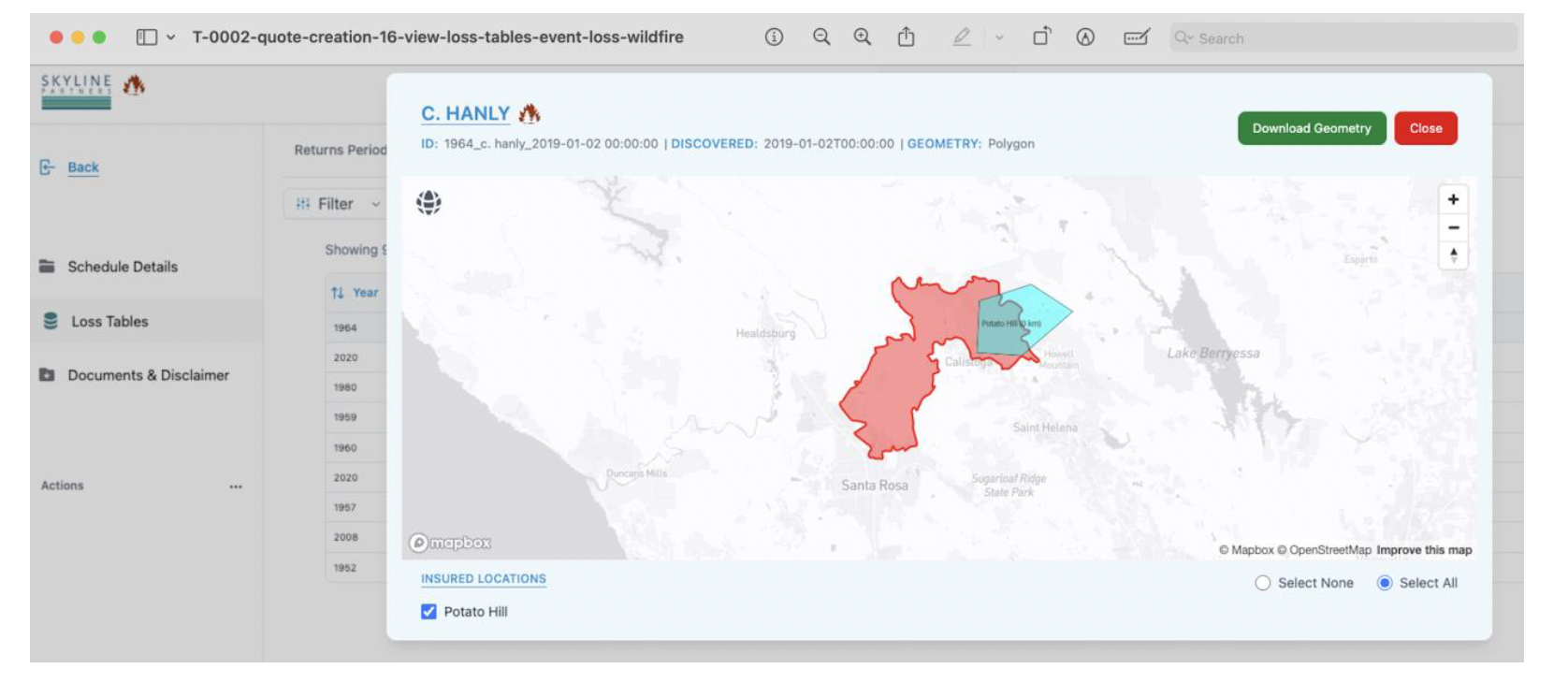
The wildfire and drought products were implemented within the functionality of the proposed technology architecture. Working with pilot customer, a Reinsurance broker, for the wildfire product, the technology was adopted in California, USA with a local company, who operate as insurance MGA/ distribution agent in the region with focus on wildfire risk. The product was underwritten by the insurance and reinsurance markets.
During the pilot which ran from the end of July 2025 to December 2025 a total of 62 parametric wildfire quotes were generated using the platform, which resulted in 14 policies sold, representing an 23% conversion rate, which is double the targeted 10% conversion in the business case.
The drought product was created with input from a large UK insurance mutual, and feedback was used to refine the product. Despite the initial interest in the product for their clients in the UK, the UK Insuance Mutual decided not to implement the pilot in a “live” format in the required timeline, however did provide feedback from their agent network during the pilot period based on the proposed product structure and the demonstration of supporting technology platform.
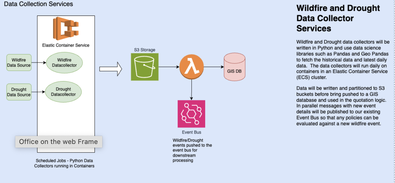
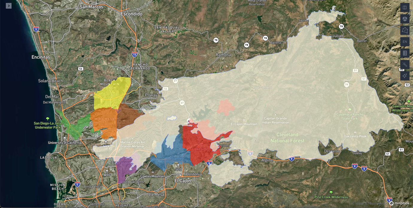
Skyline’s proprietary basis risk reduction algorithm optimizes the selected geometries to truncate zones with no or limited economic value, more likely exposed to wildfire hazard.
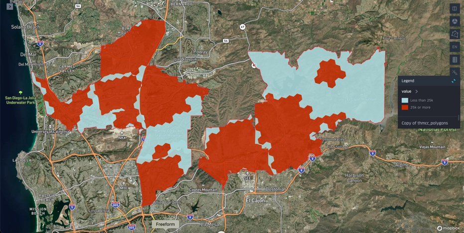
- Skyline’s settlement process overlays fire perimeter (using space asset data) with the insured geometries and Total Insured Values
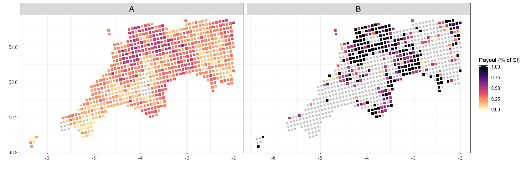
Illustration for CEDAR 2003:
Drought
Geographic distribution of the payout due in 2022 as a percentage of the policy Sum Insured for the low deductible & payout rate for 2 options one with highed deductible & payout rate.
Prime Contractor(s)