

Objectives of the service

The primary users, drone and vertiport operators, face significant challenges in tactical flight planning due to the difficulty of interpreting multiple weather sources for real-time decisions, unreliable visibility forecasts, and the need to manually account for dynamic factors like payload and battery state.
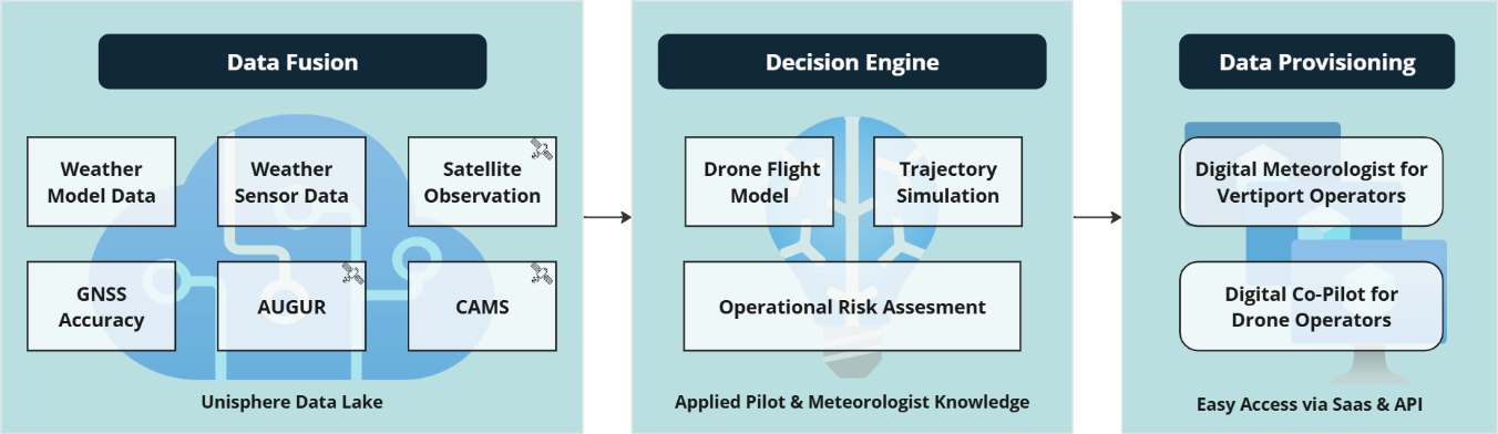
The FLAMINGO project solves these problems by developing two integrated software services: the Digital Co-Pilot for drone operators/OEMs and the Digital Meteorologist for vertiport operators. These tools automate flight planning and weather-based decision-making by integrating three key space assets:
-
Satellite nowcasting for short-term thunderstorm prediction.
-
Copernicus Atmosphere Monitoring Service (CAMS) data to improve visibility forecasts.
-
Receiver Autonomous Integrity Monitoring (RAIM) predictions for reliable navigation performance.
These services are provided through Unisphere's existing NOVA SaaS-platform and via APIs for easy integration into other systems. The new capabilities will be validated through pilot demonstrations in offshore drone logistics and real life vertiport operations, supporting launch customers and commercial adoption.
Users and their needs
The two main user groups are based in Europe, North America, the Middle East, and Southeast Asia. Generally, both services are available on a global scale.
-
Drone operators and OEMs who regularly conduct BVLOS missions. These flights involve higher operational complexity due to the need for planning over longer distancer with potentially changing environmental conditions and the sensitivity of drones to weather impacts on flight time and energy consumption.
-
Vertiport operators develop and manage infrastructure for AAM services. Their landing sites are a critical element of emerging eVTOL networks and differ from today’s airports, e.g., through remote network operations and a higher level of automation.
The following user needs are solved with the development in FLAMINGO project:
| Drone operators | Vertiport operators |
|---|---|
| Accurate, consolidated weather data for safe BVLOS operations. | Centralized, automated weather intelligence for multiple sites. |
| Reliable GNSS availability forecasts | Forecasting of vertiport service availability without on-site meteorologists. |
| Dynamic flight performance modeling (payload, battery state). | Integration into network management systems. |
| Automated go/no-go decision support to handle last-minute changes. | Cost-efficient, scalable operations with minimal staff. |
Challenges for the project
-
Integration of diverse data sources, such as satellite, radar, CAMS, GNSS, forecasts, and observations, into real-time decision support. This requires advanced data processing capabilities and measures to ensure high data quality.
-
Achieving accuracy and automation that significantly reduces the operators' workload and builds trust in data quality despite the uncertainty inherent in weather data.
-
Balancing the need for cutting-edge capabilities and advanced technology development with cost sensitivity in early-stage markets with limited willingness to pay.
Service/ system concept
The FLAMINGO project provides two key services:
Digital Co-Pilot (Drone Operators/OEMs): It provides automated flight planning that integrates satellite nowcasting, radar, CAMS air quality, and GNSS predictions with high-resolution weather forecasts and aviation weather data. Our decision engine models drone performance, considering battery and wind impact, to provide precise flight times, energy usage, and automated go/no-go decisions and alerts for high-risk weather conditions.
Digital Meteorologist (Vertiport Operators): A centralized weather intelligence service that aggregates multiple data including advanced aviation-grade weather sensors at the vertiport, high-resolution forecast data and space-based nowcasting to better manage the vertiport service availability and gain insights into operational impact. It supports efficient scheduling and network management without requiring on-site meteorologists.
The FLAMINGO system collects data from satellites, weather sensors, radar, and navigation systems. All this information is sent to a central processing engine (the “data lake”), where it is combined and analyzed automatically. From there, the system provides two easy-to-use services.
In simple terms:
FLAMINGO aggregates a multitude of relevant data for drone and vertiport operations, including space- and ground-based weather data, as well as space-based GNSS data. It interprets this data by applying algorithms that mirror the decision-making processes of pilots and meteorologists. This allows it to deliver clear, actionable guidance to users, thereby reducing their workload and improving safety.
Space Added Value
The FLAMINGO project integrates three key space assets to enhance drone and vertiport operations:
-
Weather satellite imagery provides near real-time nowcasting of thunderstorms, clouds, and precipitation. This significantly improves short-term weather awareness compared to standard numerical forecasts, which often miss localized, short-term, fast-developing weather events.
-
Copernicus Atmosphere Monitoring Service (CAMS) supplies air quality and particulate matter forecasts (PM2.5/PM10). Combined with humidity data, this enables far more accurate visibility predictions than conventional models, which struggle with haze, fog, and pollution effects.
-
RAIM (Receiver Autonomous Integrity Monitoring) predictions from Eurocontrol’s AUGUR tool enhance GNSS reliability assessments. Unlike current methods that rely only on the KP-index, integrating RAIM ensures operators can anticipate navigation signal outages with higher confidence.
Added value: Current offerings in the market provide either raw weather forecasts or fragmented data feeds, leaving operators to interpret conditions manually. FLAMINGO uniquely fuses satellite, atmospheric, and GNSS data into automated decision-support tools, delivering clear, actionable insights. This approach reduces operator workload, increases safety, and enables scalable, cost-efficient operations—advantages that existing, non-integrated methods and weather service providers cannot match.
Current Status
Since the project started in May 2025, the service requirements and system architecture have been finalized along with the potential customers and users. The CDR has been held successfully in March 2026. The implementation and verification stage is progressing nominally and is expected to be concluded by 2026.