

Objectives of the service
The service addresses a growing challenge for insurers: the sharp increase in damage to buildings caused by drought-related soil movement. Current tools are coarse, static, and often unreliable, making it difficult for insurers to evaluate which properties are truly at risk, validate claims objectively, or decide when preventive action is more cost-effective than post-event repairs. Traditional geotechnical measurements are expensive, localized, and impossible to scale to national portfolios.
The proposed service uses satellite radar data (Sentinel-1 Interferometric Synthetic Aperture Radar) to measure sub-centimetre seasonal ground deformation and combine it with soil, weather, and building information. It produces dynamic vulnerability scores at parcel or building level, historical deformation signals for claim assessment, and map-based tools to support underwriting, portfolio management, and early loss detection. These insights are delivered through a web platform and application programming interfaces that integrate seamlessly into insurer workflows.
The activity aims to define and validate the technical building blocks of this service, co-design its features with insurers, test performance on real territories and real claims data and establish a credible business framework. This will prepare the service for commercial deployment within the insurance sector.
Users and their needs
The primary targeted users are French and European natural catastrophe (Nat Cat) insurers, with initial engagement conducted with MAIF (France).
Within insurance organisations, the service addresses several operational roles:
- Underwriters require parcel-level risk differentiation to improve pricing accuracy.
- Claims managers need objective historical ground movement data to validate geotechnical drought claims and support arbitration decisions.
- Risk and catastrophe modelers seek high-resolution geospatial indicators to refine portfolio exposure models.
- Loss prevention teams need tools to identify high-risk clusters and prioritise preventive interventions.
Current challenges include:
- Static and coarse hazard zoning (municipality scale).
- Limited temporal resolution of soil moisture indicators.
- High cost and limited scalability of in-situ geotechnical surveys.
- Lack of objective data in claim disputes.
The project addresses these needs by delivering building-level risk indicators derived from satellite measurements, enabling more accurate underwriting, transparent claim validation, and data-driven preventive risk management.
Targeted countries: France (pilot), with scalability across other European clay-prone regions.
Service/ system concept
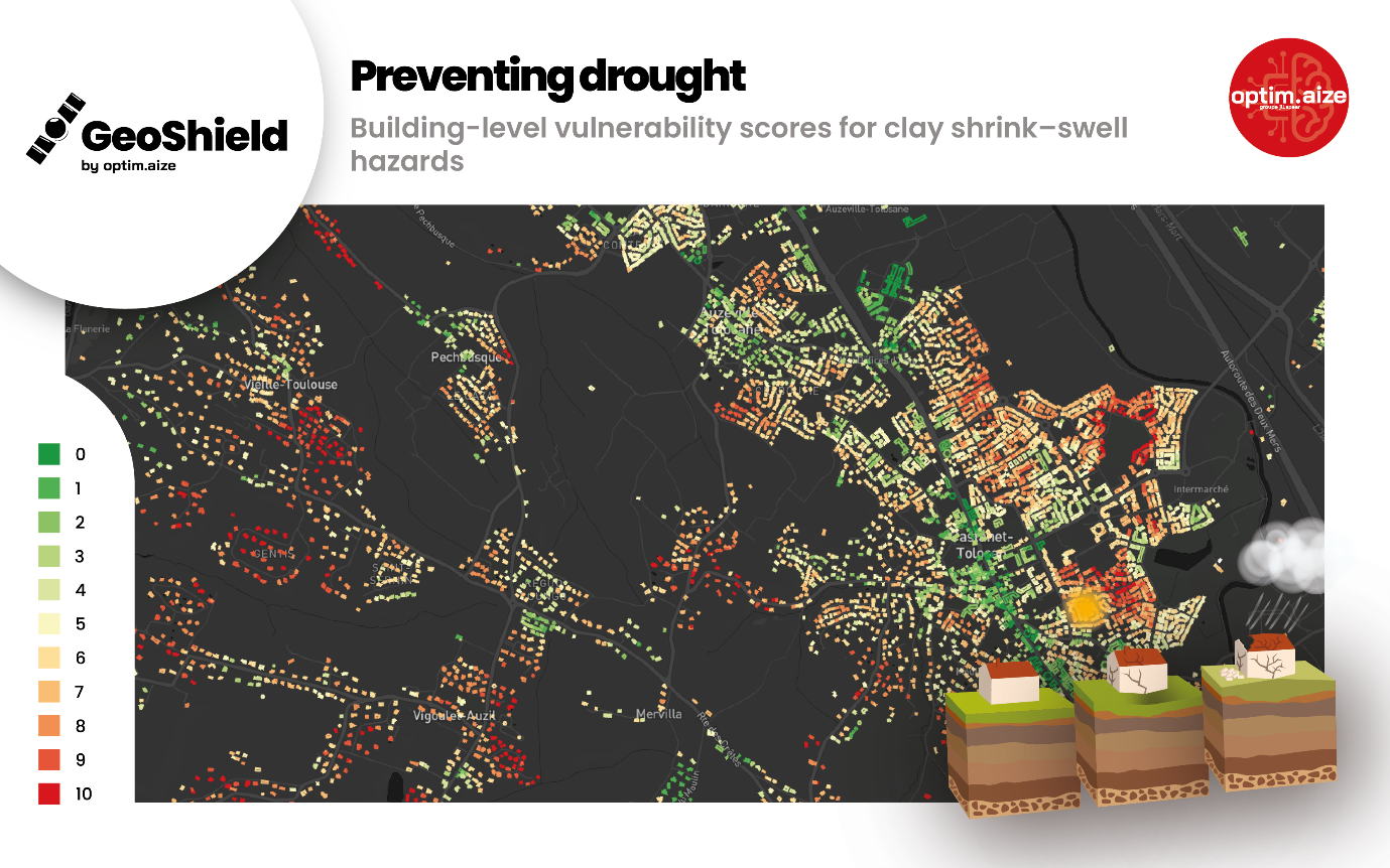
GEO-SHIELD is a satellite-enabled risk intelligence service designed to quantify building vulnerability to clay shrink–swell hazards.
The system uses radar images from the Sentinel-1 satellites to measure millimetric seasonal ground movements. By analysing multi-year deformation patterns, the service detects cyclic soil expansion and contraction linked to drought and rehydration phases.
These ground motion indicators are combined with environmental data, meteorological records, and building information. The integrated dataset feeds an explainable risk scoring engine that generates:
- Building or parcel-level vulnerability scores
- Historical ground deformation time series
- Seasonal amplitude maps
- Confidence indicators
The service is delivered through a secure cloud-based platform offering:
- Interactive geospatial dashboards
- Portfolio aggregation views
- API access for integration into underwriting and claims systems
The system architecture consists of five layers: satellite data ingestion, InSAR processing, data fusion and risk scoring, cloud orchestration, and user-facing applications. This modular architecture ensures scalability, interoperability, and compatibility with insurer IT environments.

Space Added Value
The service relies on Earth Observation assets from the Copernicus Programme, specifically Sentinel-1 Synthetic Aperture Radar satellites.
Satellite radar provides three critical advantages over traditional ground-based methods:
- Wide-area coverage – Continuous monitoring across entire national portfolios, including rural and inaccessible regions.
- High temporal resolution – Revisit time of 6–12 days enables detection of seasonal shrink–swell cycles.
- Sub-centimetric sensitivity – Persistent Scatterer and Distributed Scatterer InSAR techniques measure millimetric vertical ground displacement.
Traditional approaches such as boreholes, inclinometers or levelling surveys are localised, expensive, and not scalable to insurer portfolios covering hundreds of thousands of properties.
Satellite data provides objective, standardised and reproducible measurements, reducing human bias in claim assessment and enabling consistent portfolio-wide risk evaluation.
Without space assets, dynamic building-level monitoring of geotechnical drought would not be technically or economically feasible at national scale.
Current Status
The GEO-SHIELD activity is ongoing.
The following milestones have been achieved:
- Co-design workshops conducted with MAIF risk and innovation teams.
- Sentinel-1 multi-year datasets processed on pilot territories.
- Seasonal amplitude maps generated and analysed.
- Risk scoring indicator developed.
Work currently in progress includes calibration of the vulnerability scoring model using real sinistrality logic and refinement of the explainability framework.
Next steps include extended validation across additional territories and preparation of the final business and technical roadmap for commercial deployment.
MVP development with risk model engine will start at the end of this project if successful.
