



Objectives of the service
GEO4EN provides continuous, satellite-enabled monitoring to support the integrity and continuity of critical energy infrastructures, including gas pipelines and electricity networks. Operators face increasing operational risk due to ageing assets, ground instability, third-party interference, and extreme events. Traditional patrols and periodic inspections can miss early signals or cover limited areas.
The service integrates Earth Observation imagery with multisource information (asset context, environmental layers, and available operational data) to identify changes that may indicate emerging issues. GEO4EN supports early warning, prioritization of field checks, and consistent evidence to inform maintenance and response decisions.
The project activity focuses on demonstrating the end-to-end workflow with representative user scenarios, validating detection performance and operational integration, and refining the service to match operator processes and constraints.

Users and their needs
Targeted user communities include:
-
Gas pipeline operators (trasmission and dristibution asset management teams)
-
Power grid operators (transmission and distribution asset management teams)
-
Infrastructure owners and service providers responsible for inspection and risk management
Key needs and challenges:
-
Early identification of potential anomalies over wide areas
-
Reduced time to locate and prioritise field inspections
-
Objective evidence to support decision-making and reporting
-
Monitoring that remains effective under cloud cover and in remote areas
-
Outputs that integrate with existing GIS / asset management workflows

Service/ system concept
GEO4EN delivers alerts and contextual information to help infrastructure operators understand where relevant changes occur, what they may indicate, and how to prioritize follow-up actions.
At a high level, the system:
-
Collects data from Earth Observation sources (e.g., optical and radar satellite imagery) and selected complementary layers (asset context, terrain/environment, and available operational inputs).
-
Extracts indicators of change and risk-related signals around infrastructure corridors and assets.
-
Detects anomalies by comparing new observations with baseline conditions and expected patterns.
-
Publishes results through a dashboard and/or API, providing location, severity cues, and supporting evidence suitable for operational triage and reporting.
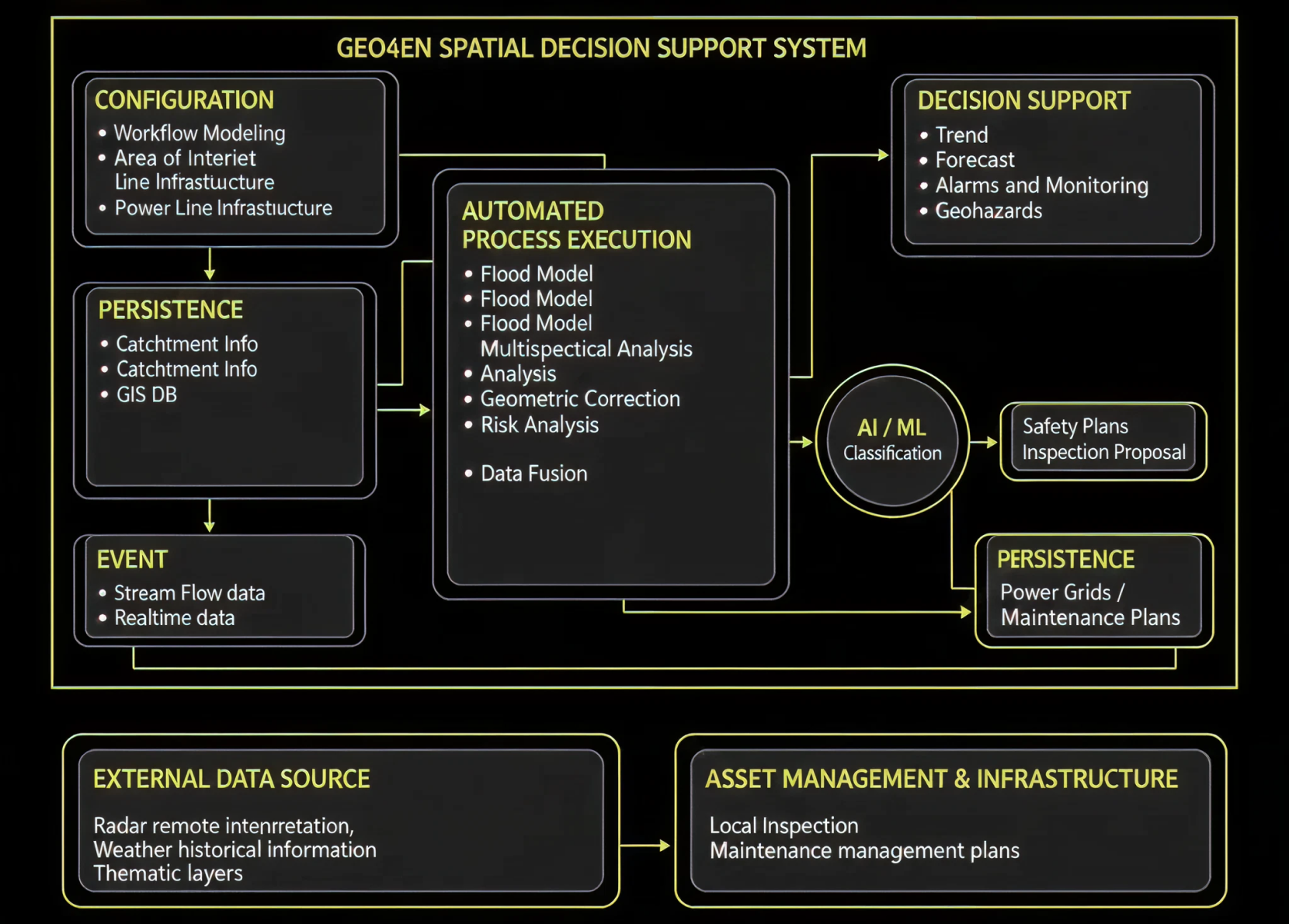
Simple architecture diagrams [Figures below] used to show the main building blocks, interfaces and the technical approach, keeping the description accessible to a wide audience and avoiding technical jargon.
Space Added Value
Earth Observation enables consistent, wide-area monitoring of critical infrastructures that span long distances and often cross remote or hard-to-access terrain. Satellite imagery supports repeated observations across large territories, helping identify changes that may not be captured by periodic ground patrols alone.
Using radar and optical satellite data complements existing methods by providing independent, scalable coverage and objective records over time. This supports early recognition of surface changes, ground movement indicators, and evolving conditions around infrastructure corridors. When combined with other available information, satellite-enabled monitoring improves prioritization of inspections and provides stronger situational awareness for maintenance and risk management.
Compared with approaches based only on on-site checks or local sensor networks, Earth Observation reduces the dependence on physical access, improves geographical completeness, and provides consistent evidence for decision support and reporting.
Current Status
At the completion of the Feasibility Study, GEO4EN has evolved from an initial service concept into a validated opportunity for EO-enabled infrastructure monitoring. The study confirmed a clear market need for solutions that improve coverage, prioritization, auditability and operational efficiency in the monitoring of linear energy assets. It also clarified that GEO4EN’s strongest positioning is as a configurable Infrastructure Monitoring as a Service offering, tailored to each customer’s assets, workflows, risk profile and operational constraints. The activity delivered a clearer service definition, initial customer validation, a preliminary business case, and the identification of the key technical and economic assumptions to be tested next. The natural next step is therefore a Demonstration Project, aimed at validating the service at larger scale, measuring operational impact, refining unit economics and pricing, and transforming GEO4EN into a repeatable, commercially deployable monitoring service.
Prime Contractor(s)

Subcontractor(s)
