
Objectives of the service
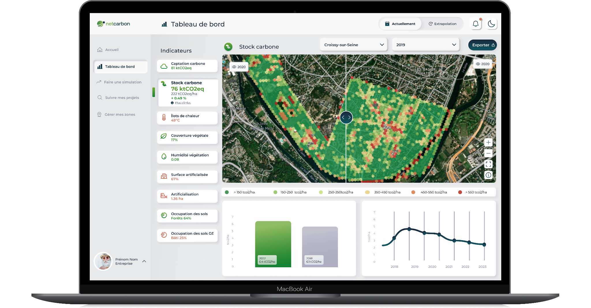
In urban environments facing climate change, adaptation and mitigation require strategies that can be measured, compared and justified. Public and private stakeholders responsible for land face two critical obstacles: the difficulty of quantifying the environmental impact of renaturation and development initiatives, and the technical complexity of designing and prioritising the right interventions.
The Netcarbon Intelligence platform is a Software as a Service (SaaS) application that supports these stakeholders throughout the project lifecycle. The application features three core functionalities: a dashboard assessing the environmental indicators of a given area, a simulation module modelling the impact of proposed projects before construction starts, and a Monitoring, Reporting and Verification (MRV) module tracking outcomes over time against existing certification standards.
The activity aims to accelerate the deployment of renaturation and low-artificialisation policies, contributing to climate change mitigation and adaptation. By providing accessible, actionable and data-driven insights, the service enables clients to embed environmental considerations into their planning processes, improving sustainability and compliance with evolving regulatory frameworks such as the French Zero Net Artificialisation objective, RE2020 and the CSRD.
Users and their needs
The targeted user communities for Netcarbon Intelligence consist of four segments in France.
Local authorities require accessible tools to comply with regulations, instruments for accurate environmental management, and means to communicate their actions transparently. Challenges include the lack of user-friendly tools and growing pressure from citizens to justify decisions.
Construction and development stakeholders, including developers, urban planners and civil works companies, need tools supporting informed decision-making on impact reduction scenarios while complying with regulatory frameworks. Key challenges include the need for multi-indicator projections and the balance between budget constraints and ecological impact.
Social housing operators and property funds manage large, dispersed asset portfolios. They need to prioritise investment across sites, understand carbon storage and regulatory labelling, and track environmental impact over time. Challenges include vague regulations complicating project analysis and the need to demonstrate measurable impact within budgetary limits.
Infrastructure operators, covering motorways, railways, ports and airports, manage extensive linear or spread-out land holdings. They need a repeatable method to assess environmental status at scale and to report on it consistently. Challenges include the sheer size of the perimeters and the absence of homogeneous field data.
All four groups require a support system addressing regulatory, educational and operational challenges to facilitate their engagement in ecological initiatives.
Service/ system concept
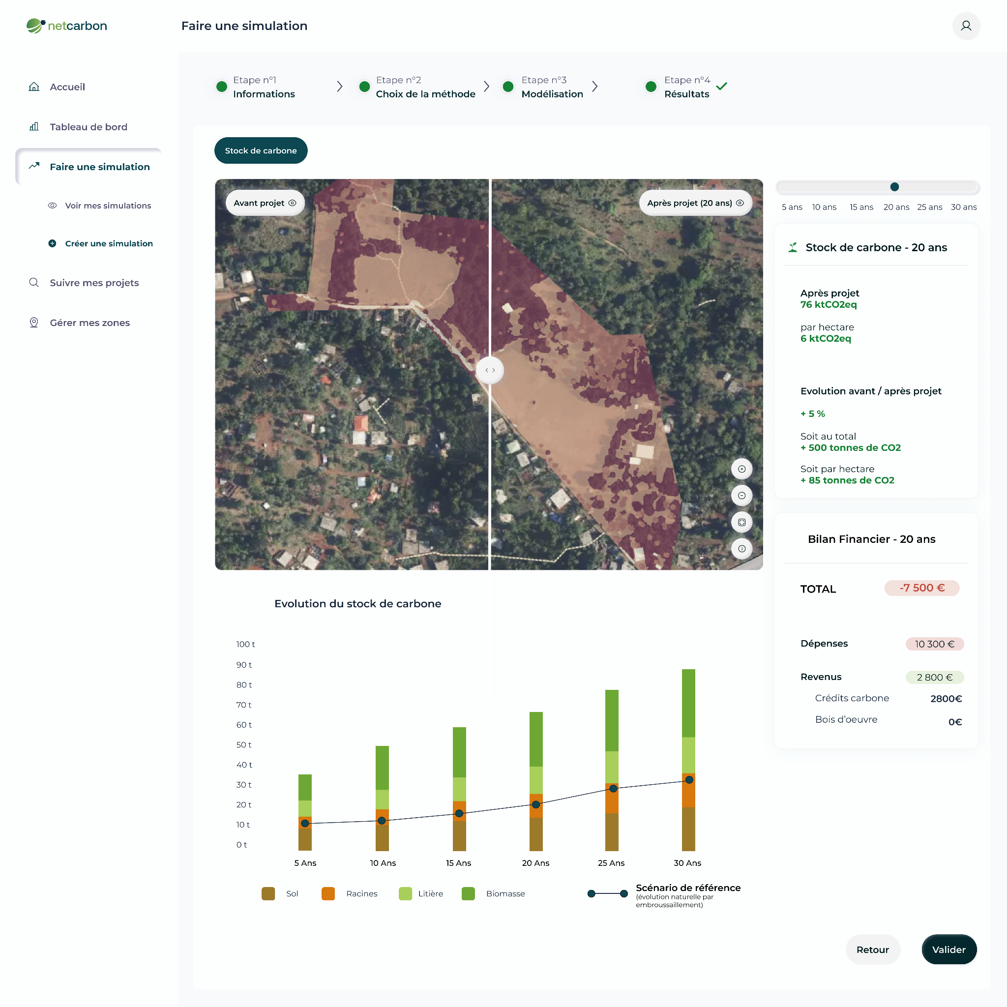
Netcarbon Intelligence delivers information on land cover, carbon stocks, urban heat islands and biodiversity, consolidated within a single dashboard. Based on the simulation module, users add or remove vegetation and built elements, and the impact of these actions is automatically quantified within the application.
Earth Observation data is retrieved through an ETL developed in Python. The ETL is containerised with Docker and deployed on the Cloud, making the required data available in the project database. Users interact with the data through the application, developed with VueJS on the front end and FastAPI on the back end.
The outputs feed a Monitoring, Reporting and Verification module, allowing project results to be tracked over time and supporting the certification of renaturation projects under the French Label Bas Carbone.
Space Added Value
Netcarbon Intelligence combines several Earth Observation sources to monitor vegetation dynamics and urban heat trends with high precision.
Sentinel-2 imagery is used to generate time series of key vegetation indices such as NDVI and NDWI, which serve as essential inputs to the environmental monitoring algorithms.
Very high-resolution imagery at 20 cm resolution is integrated to enable precise vegetation detection and change monitoring at parcel and urban block level, a scale that medium-resolution satellite data alone cannot reach.
For thermal analysis and urban heat island (UHI) tracking, Landsat 8 and Landsat 9 provide reliable thermal infrared imagery.
The combination of these sources is what makes the service possible: no ground-based method delivers comparable environmental coverage at this cost, on perimeters ranging from a single parcel to several thousand hectares.
Current Status
Platform and product
The three core modules of the platform are operational. The dashboard covers the environmental indicators defined during the user requirement phase. The second version of the simulation module has been designed and the multilayer simulation has been integrated, allowing several environmental indicators to be simulated jointly on the same project perimeter. The import plan module, enabling users to load their own project drawings into the application, is under development.
Certification
The second version of the Label Bas Carbone workflow has been integrated, connecting the diagnostic and simulation outputs to the certification requirements for renaturation projects.
Infrastructure & Data Engineering
The data processing pipeline is deployed on Cloud Run to ensure scalability. The internal MongoDB database is configured to securely store customer data, with a backup and recovery plan in place. The backend API, built with FastAPI, supports standard operations, and separate development, preproduction and production environments are in place.
Commercial deployment
The service is commercially deployed. More than 100,000 hectares have been analysed to date. The platform is used by infrastructure operators, construction and development companies, social housing operators and local authorities. Netcarbon was selected as a finalist of the Contech Connect Award 2026 in Paris, with a jury including major players of the French construction sector.

Subcontractor(s)