
Objectives of the service

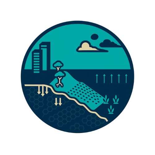
Ocean Ledger is creating a next-generation model that updates and enhances Digital Elevation Models (DEM) to support precise storm-surge prediction and coastal risk evaluation. Users, including insurers, brokers, and catastrophe-risk modellers, currently lack timely, high-resolution, and standardised coastal elevation data which impacts their pricing and solutions for resilience and mitigation. Existing datasets are fragmented, outdated, and inconsistent, limiting their ability to assess exposure, price risk accurately, and support resilience and mitigation solutions.
The Company’s product integrates satellite Earth Observation with environmental and geospatial modelling to produce a frequently updated, vertically and horizontally accurate coastal DEM. It is developing a harmonisation pipeline that fuses LiDAR, bathymetry, airborne surveys, InSAR time series, and other monitoring sources into a unified, high-resolution elevation model. This model will underpin storm-surge simulation, erosion forecasting, and compound flood assessments, feeding directly into insurance workflows.
Through the project, Ocean Ledger is building and validating the data pipeline, and demonstrating its value for exposure management and pricing. This is done through anomaly detection, coastal risk forecasting, asset-level insight, and monitoring capabilities. By providing precise and timely coastal hazard intelligence, the service addresses a growing global market need driven by climate-related risks, particularly in major cities in the US where millions of properties face increasing coastal-flood exposure.

Users and their needs
Catastrophe (cat) risk modelling agencies require accurate, frequently updated data to improve the reliability of storm-surge and coastal-risk predictions. Existing digital elevation models (DEMs) are often outdated or inconsistent, limiting their ability to model coastal hazards with confidence. Ocean Ledger’s globally applicable solution provides a high-resolution, up-to-date DEM that enhances model accuracy and strengthens coastal impact forecasting for insured assets and infrastructure.
Property and port underwriters also rely on dependable elevation data to validate catastrophe model outputs in highly exposed coastal regions. They need clear insight into hurricane and storm-surge vulnerabilities at both aggregate and individual-property level. By integrating Ocean Ledger’s DEM, underwriters can assess exposure more accurately and underwrite with greater confidence. Regular updates, monthly and post-event, further support faster, more informed claims processing.
Brokers, meanwhile, must advise clients on evolving climate-driven coastal risks but often lack consistent, long-term intelligence. They need robust analytics to quantify flood and sea-level-rise exposure and to recommend effective mitigation strategies. Ocean Ledger’s continuous coastal-asset monitoring provides actionable insights that help brokers identify vulnerabilities, guide investment in flood defences, and build knowledge well ahead of renewal periods.
Service/ system concept
Ocean Ledger’s service delivers up-to-date coastal elevation data, storm-surge insights, and shoreline change forecasts through an API, dashboard, or third-party integrations. Users receive pre-loaded datasets for rapid access, plus clear documentation on accuracy, methods, and uncertainty for internal modelling teams. It also trains models on client claims data to show the financial ROI of using Ocean Ledger’s enhanced digital elevation model compared with traditional inputs.
Two products are offered: (1) a portfolio-level assessment for insurers and lenders, and (2) single-site “risk deep dive” reports with optional bespoke features. These enable users to underwrite, lend, and plan more confidently in high-exposure coastal areas, improve risk selection, and optimise reinsurance strategies.
In a nutshell, the system works by regularly measuring how coastlines change, how the seabed, beaches, and natural barriers rise, sink, or erode, and turning these measurements into clear forecasts of future flooding and shoreline shifts.
As for the architecture, it combines multiple satellite sources, ground data, and reference datasets into a unified processing pipeline. This pipeline updates coastal elevation models and generates storm-surge and erosion predictions that can be delivered instantly via the API. The first portfolio product will launch in the US, with deep-dive assessments available globally.
Space Added Value
Ocean Ledger’s technology combines advanced satellite Earth Observation with high-quality reference data to generate accurate, time-resolved maps of coastal morphological change. Using modular workflows, it produces spatial and temporal products for bathymetry, shoreline movement, and natural coastal defences. These datasets enable tertiary insights, such as identifying shoreline-change hotspots and generating forecasts for climate and hazard models, and form the foundation for building precise, updateable digital elevation models (DEMs).
A key differentiator is the Company’s ability to quantify the role of natural flood defences. For example, by measuring mangrove canopy height, it is possible to estimate their capacity to attenuate storm surge. Incorporating this information enables highly precise, easy-to-update forecasts across both local and regional scales. This supports prediction of erosion patterns, shoreline migration, and coastal-flood impacts under various climate scenarios, providing communities and decision-makers with actionable intelligence for mitigation, response, and long-term adaptation.
Ocean Ledger’s proprietary data pipelines integrate inputs from at least eight satellite platforms, including multispectral, SAR, and LiDAR systems, alongside open-source datasets from NOAA, NASA, ESA, and national agencies. This architecture follows a “globally applicable, locally specific” design, ensuring that all models are both scalable and sensitive to regional conditions.
Current Status
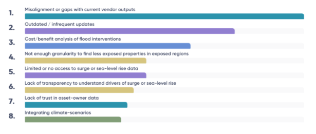
Ocean Ledger has completed two technical workshops with ORRAA, engaging senior and mid-level teams from NatWest, BNP Paribas, Barclays, Standard Chartered, AON, Marsh, Iberostar Hotels, AXA XL, WTW, FloodFlash, Beazley and the Insurance Development Forum. Participants mapped their biggest blockers, revealing five cross-sector gaps: outdated shoreline data, opaque uncertainty in loss drivers, confusion between resolution and granularity, inconsistent scenario baselines, and missing representation of natural defences in models.
We also completed a case study with KatRisk to test how Ocean Ledger’s updated shoreline intelligence and elevation model shift surge outputs. Results showed clear deltas in vulnerability and loss potential, demonstrating a viable “co-modeling” approach that enhances existing vendor models without workflow disruption.

Current work focuses on preparing new pilots with insurers, reinsurers, and brokers to validate surge-risk value, quantify premium uplift, and test flexible scenarios. US-wide deployment is planned for 2027.
Prime Contractor(s)
