Objectives of the service
In the Nordics around 50% of the yearly water used for hydropower production is stored in the form of snow during the winter period. However, hydropower producers struggle with estimating the amount of water contained in the snowpack. Existing modelling tools and snow measurements campaigns are prone to different challenges such as limited accuracy, data quality, and high costs, particularly when larger areas are to be covered.
By use of radar satellite measurements, the project wants to demonstrate an operational solution that is providing snowpack measurements with a sampling time of 14 days or better. The final product has a resolution of 50m x 50m per pixel which 100s time higher resolution compared to existing products in the market. With EDInsights solution there is no need to send personnel and equipment high up into the mountains to perform measurements as the satellite(s) would scan the areas in a matter of seconds and with a sampling period of 14 days or higher. With the in-house developed (InSAR) processing techniques users would be able to access time-series of snowpack measurements for their basins or larger areas within 1 week after satellite measurements are collected.
Users and their needs
EDInsights is collaborating with largest hydropower producers in Norway/Nordics and renewable energy companies in Europe. The target users are production planners and hydrologists that are managing production planning and snow measurements for hydropower basins in southern Norway.
The user needs are;
-
Accurate snow measurements for hydropower basins. Accuracy should be within 15% of true snow storage.
-
Multiple updates throughout the snow accumulation period
-
Delivery of updates within 1 week after measurement is performed.
-
The 2 main challenges of the project are;
Validation is challenging as the users today can be uncertain of the snow estimations themselves. It is not given that a good alignment between satellite and in-situ measurements for one site automatically translates to a good alignment for a larger areas or other points. Also, a bad alignment with in-situ measurements doesn´t translate to bad estimations for a larger region. Consequently, a lot of effort needs to be put on the validation to conclude on the robustness and accuracy of the satellite snow estimations.
If atmospheric contributions to the phase signal are not removed properly it may impact the resulting snow estimations, hence state of the art techniques need to be developed to remove atmospheric contributions.
Service/ system concept
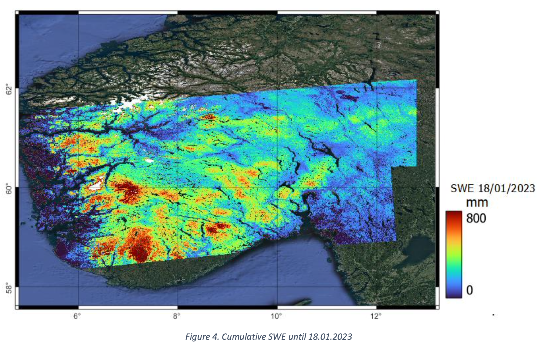
The products supplied are gridded data products with a resolution of 50m x 50m. Each grid cell shows accumulated Snow Water Equivalent (SWE) measured from the first satellite measurement. From this data average or mean SWE for a hydropower basin can be calculated or average SWE per height level.
The data products are shared with users online and results are generated within 1 week after the latest satellite measurement. While the satellite acquires measurements of up to 14 days between measurements, 3 deliveries up until snow maximum are made which considers all satellite measurements acquired until delivery.
EDInsights system is described in the illustration below;
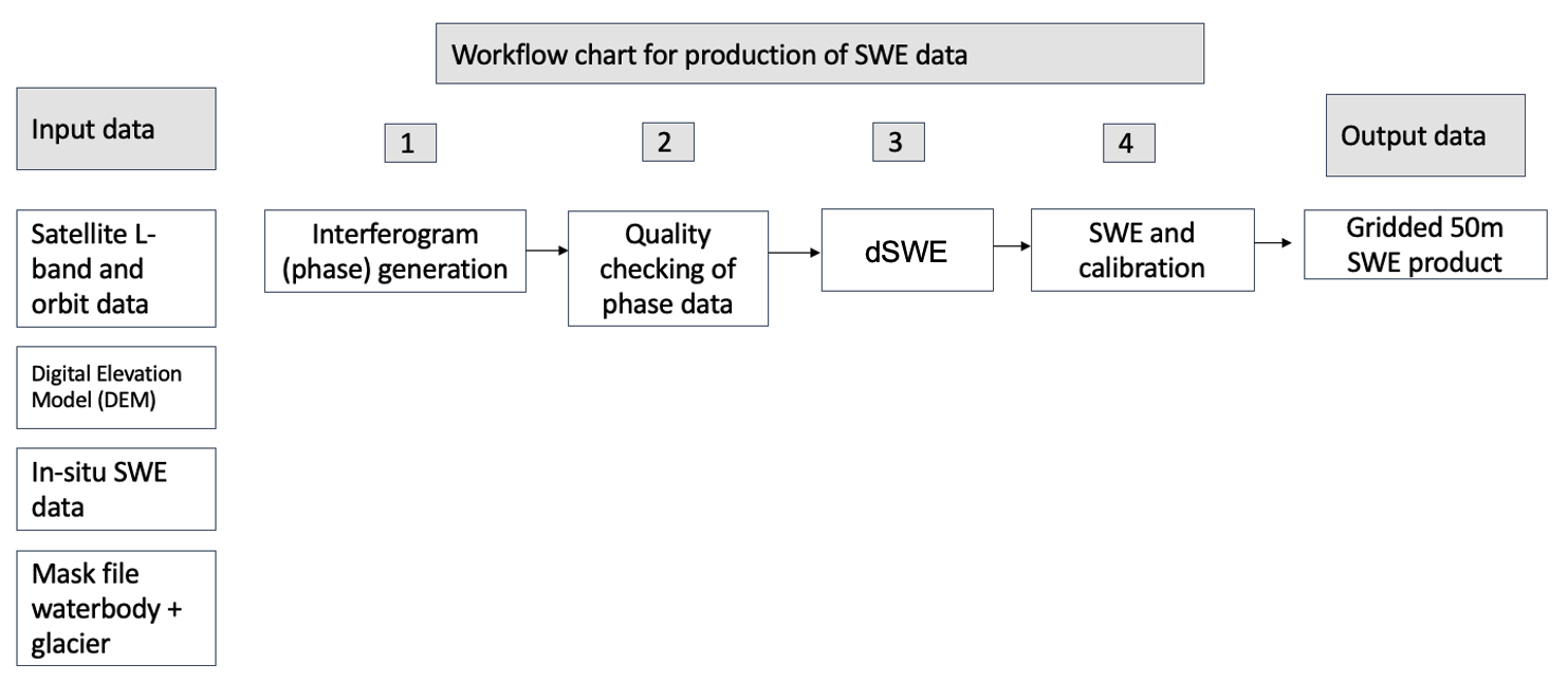
Input to the production is time-series of L-band radar measurements together with auxiliary data. The raw satellite data is processed and filtered so that the remaining phase signal is related to changes in SWE. The following steps translate dSWE products to accumulated SWE and the data is finally calibrated. The resulting output is a grid product with a resolution of 50m x 50m.
Space Added Value
For this project L-band SAR measurements are used. For the application of phase change studies (InSAR) one wants to maintain as high coherence as possible between measurements. As snow as a medium can change a lot between satellite measurements L-band is more favourable to apply due to its longer wavelength compared to C-band and X-band radar sensors.
With use of satellite measurements, the solution can provide physical measurements of the water content in the snowpack covering large areas and with minimal modelling involved. This enables the users to get up-to-date snowpack estimations for their basins without using any human resources or equipment needed, which in turn saves costs and at the same time provides the same or better accuracy of snow estimations as when using more traditional methods.
Users would also get an added value in terms of that they can get access to snow measurements where they previously have not been able to do measurements due to costs, security, or environmental reasons. In addition, users now get higher sampling of physical snow measurements compared to existing solutions used.
Current Status
Following a successfully executed pilot Demonstration and CCN#1 covering + 20 hydropower basins in southern Norway the project has now finalized a successful CCN#2. The goal of the CCN#2 was to validate and further quantify the accuracy of run-off estimations using the developed satellite SWE product and based on 6 years of historical ALOS-2 measurements across southern Norway.
The results from the CCN#2 show that by directly replacing the modelled SWE in operational run-off models with satellite SWE estimations, that the run-off estimations can be further improved. The satellite SWE does not improve the run-off in all cases but once it performs better the absolute errors on run-off estimations is between 5-13% during a pre-defined validation period window and which cover the melting period of the year. This error margin is equally as good or better compared to modelled snow storage by the pilot-users.
Further accuracy improvements can be made by calibrating a run-off model using satellite SWE estimations in combination with applying L-band measurements from the NISAR data which is believed to provide more robust ionospheric estimations and thus contribute to further improve accuracy of the satellite SWE products.
The PowerEdge products are being offered commercially.
Prime Contractor(s)