Objectives of the service
Rheticus® Electric Towers (RELECT) addresses the critical need of Transmission System Operators to rapidly locate and assess damage to high-voltage power lines after extreme weather or hazardous events. Current inspection methods rely on on-site surveys or aerial campaigns, which are slow, costly and often unsafe or infeasible in adverse conditions.
The service provides a satellite-based solution using very high-resolution Synthetic Aperture Radar imagery, 3D models of power lines and Artificial Intelligence. It delivers reliable damage assessment of electric towers and conductors within 24 hours, regardless of weather or daylight, enabling faster decision-making, reduced outage times and lower operational costs.
The project aims to industrialise this capability into a scalable, automated service integrated into the Rheticus® platform. This includes developing modules to optimise satellite acquisition geometry, automate data retrieval and processing with a multi-constellation capability, and provide a user-friendly interface for rapid service activation and output delivery, ultimately improving the resilience and sustainability of energy networks.
Users and their needs
The service targets Transmission System Operators (TSOs) managing high-voltage electricity networks, primarily in Europe, with an initial focus on Italy. Terna S.p.A. is the pilot user, representative of this community.
These users must ensure rapid restoration of service and network resilience during extreme events.
Key user needs:
- Rapid localisation of damaged assets during emergencies, day and night;
- First integrity insights within 6–8 hours and full assessment within 24 hours;
- Assessment of towers, cross-arms and conductors;
- Reliable performance in all weather and visibility conditions;
- Simple, guided user experience during emergency operations;
- Continuous access to clear, easy-to-understand information;
- Prioritised, actionable outputs to plan inspections efficiently;
- Reduction of costly and risky field inspections;
- Interoperability with Geographic Information Systems and asset management systems;
- 24/7 service availability and rapid activation.
Key challenges:
- Ensuring rapid access to suitable satellite data with optimal acquisition geometry;
- Delivering accurate, automated detection across diverse conditions;
- Providing intuitive outputs for non-specialist users under time pressure;
- Integrating with operational workflows and cybersecurity requirements.
The service should combine speed, reliability and usability to support critical decision-making and minimise outage impacts.
Service/ system concept
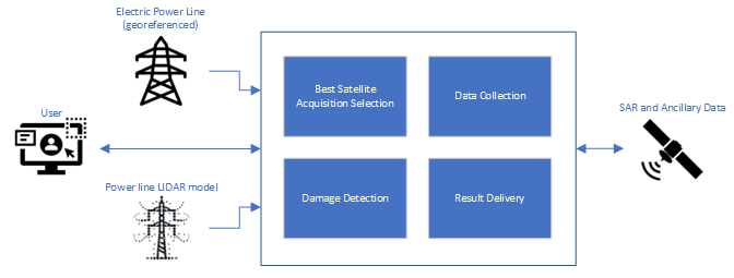
Rheticus® Electric Towers is a satellite-based service that helps power grid operators quickly understand what has happened to their infrastructure after extreme events. With a simple input (for example, a power line ID), the service delivers within a few hours clear, geo-referenced information on the condition of towers and conductors, identifying collapsed, partially damaged or intact elements and highlighting critical issues that require intervention.
The service combines satellite data, advanced analytics and automation to transform complex observations into simple, actionable insights that can be directly used by operational teams.
At a high level, the system works as follows: once activated, it automatically collects satellite data from multiple sources, analyses it using dedicated algorithms, and delivers the results through a web-based interface.
Behind the scenes, different modules handle data collection, smart selection of the best satellite acquisition, damage detection and result delivery.
The result is a fast, reliable and easy-to-use capability that enables operators to locate damage and prioritise field actions to restore power networks more efficiently.
Space Added Value
The service exploits Satellite Earth Observation (SatEO) assets, specifically very high-resolution Synthetic Aperture Radar (SAR) satellites capable of on-demand imaging with up to 25 cm resolution and rapid tasking.
The added value of these space assets lies in their all-weather, day-and-night acquisition capability, ensuring continuous monitoring even under cloud cover or severe conditions. This overcomes the major limitations of current methods, such as helicopter inspections, drones or optical imagery, which depend on visibility, accessibility and favourable weather.
By combining SAR data with 3D models of power lines, optimised acquisition geometries and Artificial Intelligence-based processing, the service enables fast, remote and automated detection of damaged infrastructure within 24 hours.
Compared to existing solutions and competitors, which typically rely on optical data or indirect indicators (e.g. vegetation monitoring) or semi-automatic analysis, the service provides multiconstellation, direct, on-demand post-event damage assessment of towers and conductors using SAR imagery. This approach ensures higher reliability and operational continuity, reduces costs and risks, and delivers actionable insights when traditional and competing methods are ineffective or unavailable.
Current Status
The project team completed the review of the user needs in close cooperation with Terna S.p.A., the Italian Transmission System Operator. This collaboration helps shape a solution that is both technically robust and easy to integrate into the user’s operational workflows. The user needs have been translated into user requirements, leading to the definition of the system requirements.
Meanwhile, marketing and business development actions have led to expressions of interest in the service from other TSOs across Europe.
The project will be presented during the International Astronautical Federation (IAF) Earth Observation Symposium at the 77° International Astronautical Congress (Antalya, Türkiye, 5 - 9 October 2026).