

Objectives of the service
Cities and infrastructure companies across Europe face major challenges in assessing the condition of cycle lanes. Traditional methods are costly, slow, and often lack the precision and scalability required for effective planning and maintenance. As cycling becomes central to sustainable urban mobility, the need for timely, reliable, and affordable infrastructure data is growing.
The ROAD SYSTEM Mobile App directly addresses these problems by offering a smartphone-based tool that uses artificial intelligence and satellite navigation data (Global Navigation Satellite Systems) to detect and classify pavement issues such as potholes and cracks. Data is automatically uploaded to a cloud-based mapping platform where users can view and analyze cycle lane conditions in real time.
The service provides up to 80% cost savings compared to traditional audits, enabling broader and more frequent assessments. It also empowers cities to involve municipal workers or cyclists in data collection, improving coverage without extra hardware.
This project addresses the full-service chain—from mobile data collection to automated analysis and decision support—validating performance across different urban and regional environments. The goal is to demonstrate its value in supporting safer, more efficient, and better-managed cycling infrastructure across Europe.
Users and their needs
The ROAD SYSTEM Mobile App targets public authorities and infrastructure professionals responsible for planning, maintaining, and auditing cycling infrastructure. Current users include city departments, regional mobility agencies, and private engineering and auditing firms in Denmark, Italy, France, Belgium, Bosnia and Herzegovina, and Spain.
Pilot users engaged in this activity include:
-
Sertec-Engineering (Italy and France)
-
Celis Consult (Denmark)
-
City of Sarajevo (Bosnia and Herzegovina)
-
DOLL Living Lab (Denmark)
These users represent a mix of urban, regional, and national stakeholders managing cycling infrastructure with varying resources and technical capabilities.
User needs and challenges include:
-
Affordable, scalable assessments of cycle lanes
-
Reliable, high-accuracy data to support planning decisions
-
Tools that are easy to deploy without technical expertise
-
Integration with existing city mapping and management systems
-
Real-time insights for proactive maintenance
-
Standardized data formats for comparison and reporting
The project ensures ease of use for non-technical staff, delivers consistent results across different countries and infrastructure types, and demonstrates clear cost savings and improved planning outcomes to meet the needs of these diverse users.
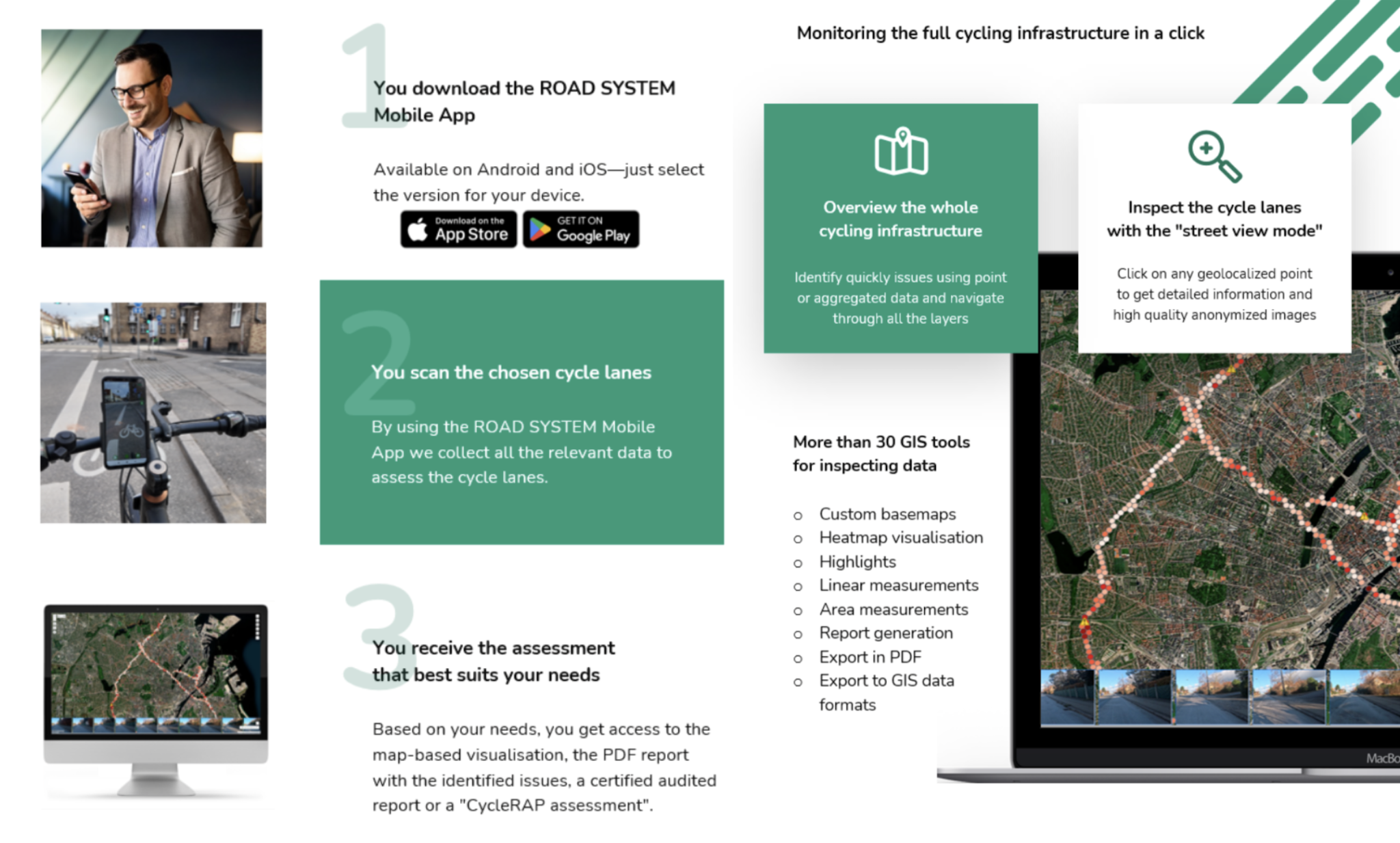
Service/ system concept
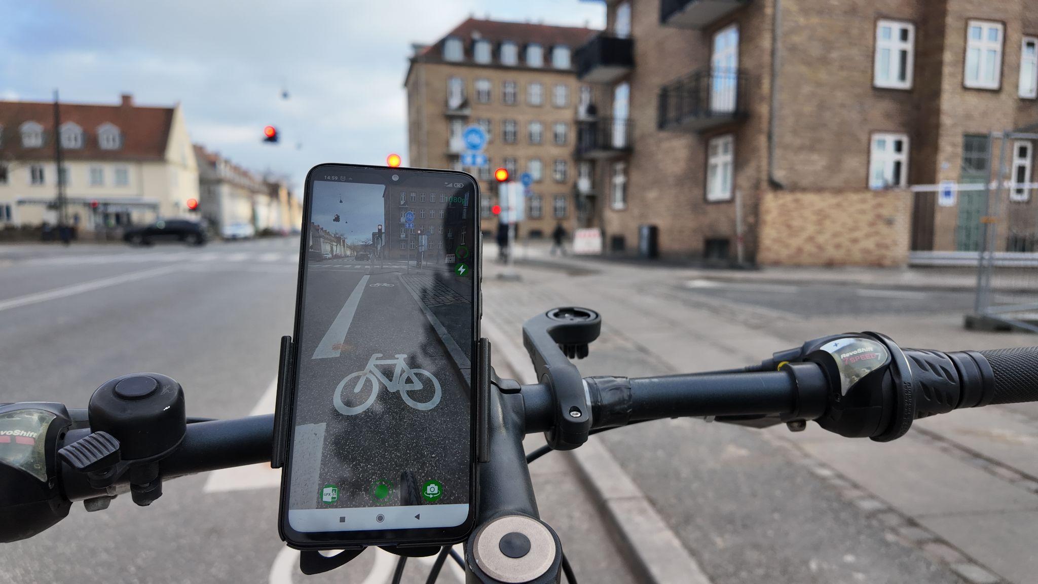
The ROAD SYSTEM Mobile App allows cities and infrastructure professionals to easily collect and access detailed information about the condition of cycle lanes. Using only a smartphone mounted on a bicycle, users can record video and sensor data while riding. The app automatically detects surface issues like potholes and cracks and sends the data to a secure online platform.
Once uploaded, the data is processed and displayed on a web-based map. Users can view high-resolution images, see where problems are located, and understand how severe they are. This helps city planners and road managers make quick, informed decisions about where to repair or improve cycling infrastructure.
At a high level, the system has three parts:
-
A mobile app used to collect data during regular bike rides.
-
A cloud-based backend that stores, analyzes, and organizes the data.
-
An interactive online map (GIS platform) where users can review and manage all the information.
This service makes it possible to monitor cycle lanes in real time, using everyday devices, without the need for expensive equipment or manual inspections—saving time, money, and helping cities keep cyclists safe.
Space Added Value
Describe in less than 200 words which space assets are used, the expected added value of using and/or combining space assets to achieve the goals as opposed to using current methods from potential existing competitors.
The ROAD SYSTEM Mobile App uses space-based data from Global Navigation Satellite Systems (GNSS), specifically the Galileo satellite system, to ensure high-precision location tracking. This accurate positioning is critical for mapping cycle lane conditions with confidence and for aligning sensor data—such as vibrations and speed—with exact geographic points.
By using Galileo, the app can capture even small road surface issues with a high degree of spatial accuracy. This level of detail is essential for infrastructure teams to identify problem areas and prioritize repairs effectively. Compared to traditional methods, which often rely on manual inspections or expensive, vehicle-mounted sensors, Galileo enables a low-cost, scalable solution that maintains accuracy while using only smartphones.
Combining Galileo’s high-accuracy positioning with real-time data from the app and cloud-based processing allows cities to monitor thousands of kilometers of cycle lanes at a fraction of the cost—up to 80% less per kilometer—of conventional approaches. Competitors typically focus on car roads or require specialized equipment, while our solution brings advanced assessment capabilities to bike infrastructure using only consumer devices enhanced by satellite technology. This makes widespread, frequent, and affordable monitoring finally possible.
Current Status
The ROAD SYSTEM Mobile App has been fully developed and is now ready for real-world testing. The solution includes a cross-platform mobile application for data collection, a cloud-based backend for processing, and a web-based GIS platform for visualizing and managing cycle lane assessments. The system has been technically validated in controlled conditions and is now prepared for pilot deployment across multiple European cities. Key users—including municipalities and engineering companies in Denmark, Italy, Spain, and Bosnia and Herzegovina—have committed to testing the solution in diverse urban and regional environments. The upcoming pilot phase will evaluate performance, usability, and accuracy in real conditions, ensuring the service meets operational needs before scaling.
