
Objectives of the service
Energy transmission and distribution networks are spread over thousands of kilometers, often in remote areas. The maintenance of the networks is costly, and the networks are vulnerable to storms, falling trees and third party operations.
Information collected by satellites can be used to make the maintenance of the networks more efficient, to reduce risks due to the changing environment, and to mitigate the risk of interruptions. The vast amounts of satellite information can be processed automatically with the aid of AI, and the maintenance processes can be automated and made more efficient.
More secure supply, safer networks, and lower cost and potential for tariff reductions in Europe and the rest of the world are all possible benefits from the SatNetMonitor project.
Users and their needs
Both DSOs and TSOs spend hundreds of millions of Euros for operating and maintaining the electricity network. The network companies and their partners are constantly looking for ways to improve the processes in operation and maintenance.
SatNetMonitor’s Vegetation Management Service will replace most of the costly periodic network inspections and avoid unnecessary work while improving the reliability of the network. Risk maps for vegetation, snow and ice, and wind can be used for making the network more secure. Other benefits include monitoring of tree cutting and othervegetation management operations.
SatNetMonitor’s Infrastructure Risk Detection service will benefit both urban and rural networks. Unauthorized construction will be detected both under overhead lines and over underground cables. Costly interruptions and risks to third parties can be avoided.
SatNetMonitor’s Disaster Management Service will help in managing damage and interruptions caused by extreme weather events. The risk of interruptions caused by snow, ice and wind can be reduced by utilizing results from the automated risk analysis.
The services will be usable worldwide. For vegetation analysis, parameters vary according to weather, geography, and local practises.
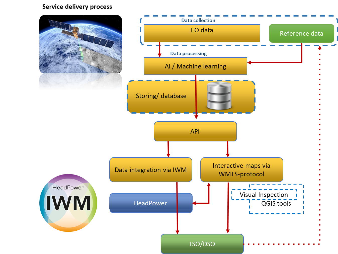
Service/ system concept
The service is able to source various types of satellite imagery and other types of satellite information. As a basis, open source Sentinel data, VHR optical data, and network information will be used. Supplementary information can be used from other sources, such as SAR, RPAS, HAPS, weather, and past events in the network.
These data will be analysed with an AI / machine learning analysis layer and compared against a risk model.
The system is automated through a task engine and customer interface. The users can get automatic tasks and alerts for themselves or their partners, and even build maintenance programmes ready for tendering or ordering.
Space Added Value
The huge volumes of satellite imagery coupled with advanced analysis makes it possible for network companies to constantly monitor networks tens of thousands of kilometres long.
Information derived through the use of earth observation satellites is used to make the operation and maintenance of the network more efficient, more economical, and safer:
- Vegetation management is made more efficient and vegetation risks are managed with Vegetation Management Service relying on EO Vegetation Analysis
- Infrastructure risks need to be monitored, but until now it has been costly. Third party activity on the network route (both overhead and cable networks) is monitored through EO Infraestucture Risk Detection Service
- Weather event impacts and risks including snow, ice, and storms are managed with EO Disaster Management Service.
Satellite communication, including SatCom/5G networks, can be used to monitor even remote parts of the network and manage field workers efficiently.
Current Status
Technical feasibility and commercial viability analyses had very favorable results. The consortium is planning for a demonstration project.