
Objectives of the service
The SETSITS project aims to transform how road operators manage highways, addressing global challenges in road safety, traffic efficiency, and environmental sustainability. Each year, over 1.3 million lives are lost in road accidents, and 5.6 billion metric tons of CO₂ are emitted. Operators, often responsible for thousands of miles of roads, rely on manual processes—such as answering phone calls and patrolling—that are prone to delays and errors. While data from connected vehicles, navigation apps, and satellites offers real-time insights, operators struggle to fully leverage this fragmented data.
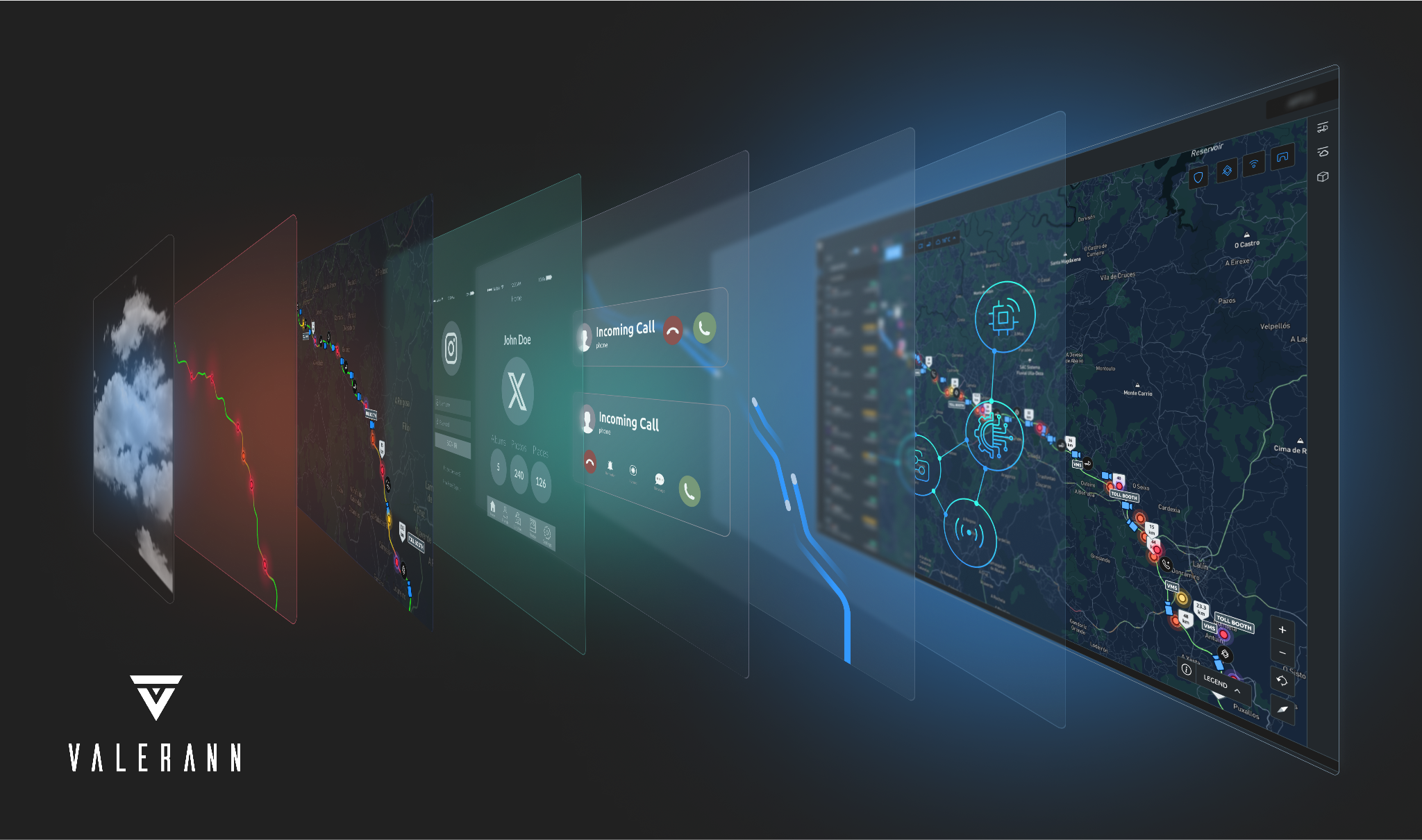
SETSITS is developing Lanternn for Networks to integrate diverse data sources, including connected vehicles, roadside sensors, and satellite-enabled weather services. This platform provides real-time visibility and actionable insights, enabling operators to proactively respond to incidents, disruptions, and maintenance needs. Satellite-enabled fleet integration enhances coordination of vehicles like emergency responders and snowploughs using live GNSS feeds, while these vehicles act as mobile data stations to strengthen road intelligence.
Aligning with the European Space Agency’s “Space for Infrastructure”, the project aims to revolutionize highway management globally and reduce accidents and fatalities, optimize traffic flow, and cut emissions, supporting smarter, safer, and greener road networks.
Users and their needs
Valerann has two primary user communities:
-
National Networks
Needs: Tailored capabilities for managing large-scale road networks, data integration, and real-time monitoring.
Challenges: Managing and analysing vast amounts of often incomplete or inaccurate data, limited sensor accuracy, and outdated infrastructure.
-
Urban Networks
Needs: Cost-effective solutions for managing urban road networks, including real-time incident detection, traffic flow optimization, and predictive maintenance insights.
Challenges: Budget constraints, limited data coverage, and need for simplified, user-friendly systems to improve traffic and maintenance operations.
Key Users
-
Road Network Control Centre Supervisors/Managers - Managers and Supervisors within road network Control Centres.
-
Road Network Control Centre Operators - Control Centre Operators that monitor a network.
-
Road Network Operator Management/Leadership - Senior leadership responsible for safety, ITS and operational strategy.
-
Network Operator ITS Implementation Teams - Cross-functional staff involved in IT operations, ITS, Project Management and Change Management that are responsible for implementing new technology solutions within the Road Network and its Control Centres.
-
Service/ system concept
The system enhances safety by increasing detection accuracy and response relevance while reducing response time for incidents such as traffic accidents, hazards, and anomalies. It prioritizes high-impact occurrences based on operator objectives, ensuring rapid and effective responses that help restore normal traffic quickly. By identifying risks early, it prevents escalation, improving network performance and traffic flow, increasing road capacity, and reducing journey times.
The system creates an interconnected repository of road monitoring data, operator actions, and behaviors, enabling strategic improvements. For municipalities, intersection monitoring supports responsive timing plans to reduce congestion and improve network fluency. By integrating transit and traffic data, operators can prioritize efficient transportation modes, minimizing network pressure and environmental impact.
Using a proprietary Data Fusion engine, the system provides accurate, real-time data, resilient to environmental conditions and unreliable sensor issues. It reduces false positives, optimizes resource use, and enhances the capabilities of existing ITS equipment without requiring costly infrastructure upgrades. Device agnostic and flexible, the system removes siloed data barriers, offering a seamless, interoperable interface. Ultimately, it delivers safer, more efficient traffic management while supporting operational excellence.
Space Added Value
The solution leverages satellite-based fleet integration and weather event alerting to enhance operational efficiency across vast road networks. By integrating with satellite-enabled fleet management systems (e.g., Webfleet), road operators are able to monitor live vehicle locations, such as emergency, patrol, and snowplough vehicles, using GNSS data to identify the closest vehicle to incidents and optimise responses. This satellite data, via secure VPN or direct network integration, improves coordination across diverse fleet types and enables proactive measures like winter maintenance based on weather forecasts. Additionally, satellite-enabled weather services provide timely alerts about hazardous conditions, such as hailstorms or ice risks, allowing operators to plan maintenance and mitigate risks more effectively. Combined, these space assets enable real-time monitoring, better prioritisation, and more informed decision-making compared to traditional methods, offering superior coverage, response time, and risk management across both national and urban road networks.
Current Status
Since the start of the SETSITS project in September 2024, Valerann has advanced the development and deployment of Lanternn for Networks, culminating in a live operational pilot with Transport Infrastructure Ireland (TII) across a national motorway network. The pilot validated the system’s capability to integrate heterogeneous data sources and deliver measurable improvements in incident detection, operational response and network performance.
In parallel, Valerann has conducted pilot activities with international road operators, using insights from these engagements and the SETSITS project to refine system capabilities and support future deployment opportunities. These activities have contributed to the evolution of system requirements, product development and commercial positioning.
Valerann has also completed a pilot deployment with Nea Odos in Greece, which has progressed into an ongoing commercial deployment, demonstrating successful transition from pilot validation to operational adoption.
Valerann is actively progressing commercial discussions with road operators at national and regional level, building on the validated results of the project. The system has received external recognition, including the Prince Michael International Road Safety Award, and has been presented at industry forums such as the Transportation Research Board Annual Conference. In 2025, the system also received the European Union Excellence in Road Safety Award and the IBTTA Toll Excellence Award, reflecting its application and impact in live operational environments.