Objectives of the service

The cloud-based web application BENTHIQ is developed as part of the Seafloor Classification Online (SFC-Online) project. It empowers stakeholders to map and monitor benthic habitats such as seagrass meadows, mussel beds, and coral reefs. Seagrass meadows in particular have received increasingly attention in recent years due to their importance for carbon sequestration, coastal protection and as habitat for marine fauna.
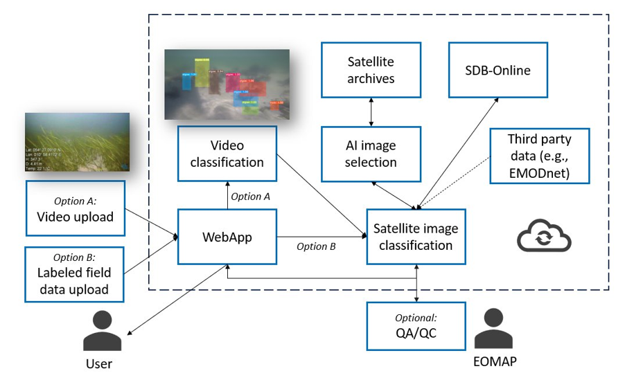
Mapping is based on Copernicus as well as commercial satellite data and does not require extensive Earth Observation (EO) expertise. The web application can digest on-site data from stakeholders, such as ground control points or underwater video transects. With semi automatic classification and machine learning routines, users can efficiently classify their video transects and automatically georeference them. Thereby, the web application addresses a common challenge when working with underwater data.
These high-quality insitu datasets can then be used to calibrate and validate satellite-based seafloor classification algorithms within BENTHIQ, while also providing habitat information that EO alone cannot capture.
Users and their needs
Primary users are governmental environmental authorities and national research centres responsible for marine monitoring and EU reporting, notably Landesamt für Umwelt Schleswig‑Holstein (Germany) and Institute of Marine Research (Norway). Secondary users are industry operators (dredging, offshore engineering such as VanOord and Fugro), environmental monitoring companies, and NGOs. These organisations may upload and analyse underwater video transects, use satellite‑derived maps for monitoring, and integrate outputs into reporting and operational workflows.
User needs
- Scalable seafloor mapping across large and fine scales
- Integrated multi‑sensor workflows (Sentinel‑2, VHR satellites, underwater video)
- Automated video analysis and georeferencing for transects
- User‑friendly tools for non‑RS specialists
- Flexible class definitions and export formats for EU reporting
- Cloud SaaS to avoid local HPC requirements
Project challenges
- Heterogeneous data fusion and geolocation accuracy
- Model transferability across regions and sensors
- Usability for non‑experts while retaining scientific rigor
- Processing and storage at scale and access to commercial imagery
Targeted countries: Germany, Norway, Greece, Italy - in general, North, Baltic and Mediterranean Sea countries.
Service/ system concept
What users receive
- Georeferenced seafloor habitat maps at 10 m and 0.5–3 m resolution.
- Automated underwater video analysis: frame extraction, object/habitat annotation, and batch classification.
- Integrated multi‑sensor outputs: Sentinel‑2, very high‑resolution satellite, bathymetry, and user videos fused for calibration and validation.
- User tools: web GIS for drawing labels, interactive annotation, model retraining, and exports in standard GIS formats.
- Cloud delivery: no local HPC required; scalable processing and automated scene selection.
How it works in a nutshell
Upload videos or VHR satellite scenes, label a few examples, then let the system learn and classify the rest. Video frames are geolocated and used to improve satellite maps. Results are quality‑checked in the web app and exported for reporting.
Space Added Value
BENTHIQ relies on spaceborne Earth Observation assets to enable large scale, repeatable, and cost efficient seafloor habitat mapping. The app uses either freely available multispectral images from the Copernicus Sentinel 2 satellites at 10 m resolution, for higher detail products, it integrates very high resolution commercial satellite data from Planet SuperDoves and Vantor satellites (0.5 - 3 m resolution). These space assets supply consistent, wide area optical coverage that can be processed through cloud based pipelines.
The added value of combining these space assets with ancillary data such as classified underwater videos is substantial. Satellite data deliver broad spatial coverage and repeated monitoring capabilities that traditional in situ surveys cannot match due to cost, time, and logistical constraints. Underwater videos add precise habitat information at species-level and serve as high quality calibration and validation for the satellite based classifications.
This hybrid approach produces more accurate and scalable seafloor habitat maps than either method alone. Competitors typically rely on either offline EO processing, empirical workflows or exclusively local underwater surveys. Thus, BENTHIQ empowers users to generate high‑quality seafloor habitat maps via a user friendly cloud platform without requiring EO expertise or access to high‑performance local computing infrastructure.
Current Status

The project has successfully completed its planning phase. Internal technical workshops concerning the classification of satellite data and underwater videos were conducted to initiate the technical development of the web application. A questionnaire on user needs has been developed so that structured interviews could be conducted with the pilot users. The results were analysed in the requirements document. The pilot users have also provided training datasets from various study sites and camera systems. This is an essential step to ensure that user requirements are fully met.
Technical development is now progressing according to the project roadmap. Dedicated teams are implementing the automated classification workflows for both satellite imagery and underwater videos.
Frontend development is already well advanced, with a prototype landing page for the BENTHIQ app in place (see image above). This prototype was created in close collaboration with the marketing team to ensure full alignment with the project’s communication and branding strategy.