
Objectives of the service
Climate change increases extreme weather events such as droughts and floods, rendering traditional hydrological models unreliable. Hydropower plant operators and energy utilities face significant financial risks on volatile intraday markets due to these uncertainties. Concurrently, local public authorities lack precise, timely information to protect critical infrastructure effectively against flood waves.
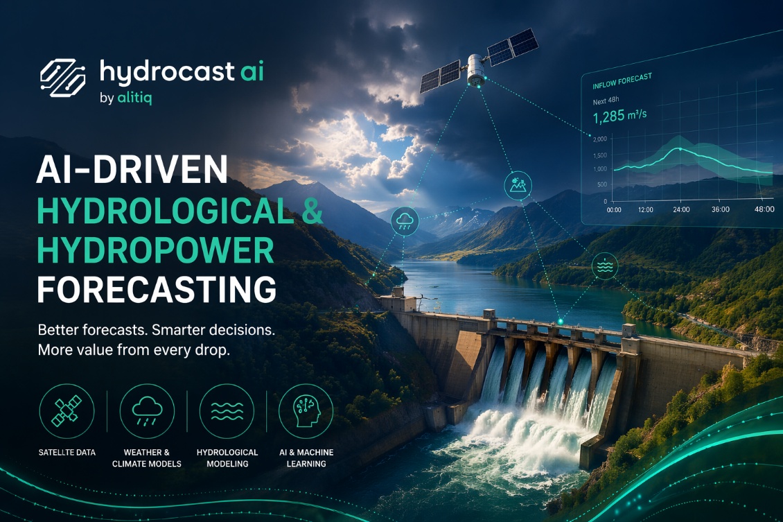
The HydrocastAI delivers a data-driven and space-enhanced forecasting solution. The system continuously integrates real-time ground data with advanced satellite Earth observations and numerical weather predictions. A specialized machine learning model processes these data streams to generate highly accurate discharge forecasts up to 120 hours in advance, accessible via a web interface and Rest-API.
The primary objectives of this feasibility study cover the technical evaluation of the system architecture and the validation of the business model. The project team optimizes the forecasting accuracy of the machine learning models and directly involves pilot customers. This approach demonstrates economic viability and prepares the service for commercial market readiness.
Users and their needs
User Communities & Invoiced Participants The service targets two distinct user communities currently active within Germany, both of whom participate directly as pilot partners in this activity:
-
Hydropower Plant Operators and Utilities: Mid-sized regional utilities managing run-of-river or reservoir plants.
-
Public and Local Authorities: Municipalities and regional water management bodies responsible for local civil protection.
User Needs:
-
Accurate Forecasts: High-precision, short-term (24 to 72 hours ahead) river discharge predictions to optimize renewable energy trading on volatile intraday markets and minimize costly portfolio balancing penalties.
-
Timely Flood Alerts: Reliable warning lead times and precise peak gauge height forecasts to proactively deploy mobile protection walls and secure municipal infrastructure.
-
Low Integration Barrier: Seamless data accessibility via automated, standard application programming interfaces that plug directly into existing control systems.
Project Challenges:
-
Extreme Weather Nonlinearity: Overcoming local data gaps during violent, convective flash-flood events to keep prediction errors exceptionally low.
-
Topographical Generalization: Training the machine learning core to adapt dynamically to differing river basin catchments without requiring manual, site-by-site physical reconfiguration.
Service/ system concept
HydrocastAI – AI-Driven Hydrological & Hydropower Forecasting
HydrocastAI provides highly accurate, hourly predictions of river discharge up to 120 hours in advance. The forecasts are accessible via a web-based dashboard and API, enabling hydropower operators to optimize electricity trading and reduce balancing costs. At the same time, local authorities gain clear timelines of upcoming water levels to prepare and deploy flood protection measures proactively.
How the System Works
The system acts as an advanced weather and water tracking platform. It continuously integrates three primary data sources:
-
real-time measurements from river gauges
-
high-resolution meteorological forecasts
-
environmental satellite observations
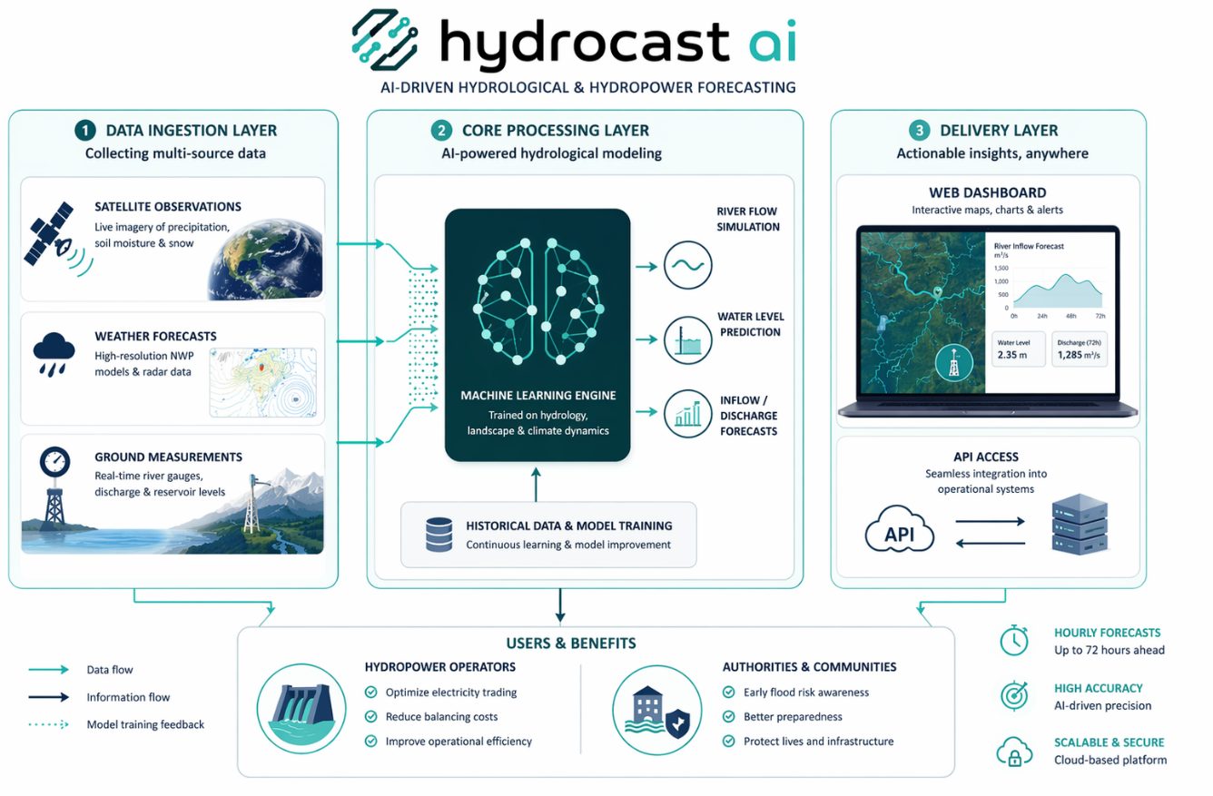
All incoming data streams are processed within a centralized machine learning model. The model captures the impact of terrain, soil moisture, and precipitation patterns on river flow dynamics. Based on these inputs, it calculates precise forecasts for specific river sections and presents them through a clear and intuitive interface.
High-Level System Architecture
The platform operates on a three-layer architecture:
-
Data Ingestion Layer
Integration of space-based observations and terrestrial measurements
-
Core Processing Layer
Machine learning engine combining data inputs and simulating hydrological processes
-
Delivery Layer
Cloud-based infrastructure providing secure access via dashboard and API
Space Added Value
The HydrocastAI platform integrates two primary categories of space assets:
-
Satellite Earth Observation (EO): High-resolution Copernicus Sentinel data supplies critical environmental indicators, specifically Sentinel-1 for soil moisture dynamics and Sentinel-2/3 for snow water equivalent mapping.
-
Satellite Meteorology (MET): Geostationary and polar-orbiting weather satellites deliver continuous atmospheric monitoring and advanced numerical weather predictions.
Expected Added Value & Competitive Advantage
Traditional competitors rely heavily on static physical models and sparse ground-based river gauges. This approach introduces significant errors during extreme weather events or across ungauged catchments.
By combining space assets with machine learning, the Company eliminates these spatial blind spots. Merging satellite EO with real-time meteorology allows the system to capture real-time landscape saturation and upstream snowpack melts before the water ever reaches a physical gauge. This space-enhanced approach provides unprecedented predictive accuracy and extended lead times, enabling hydropower operators to maximize market revenue and public authorities to receive reliable, actionable flood alerts.
Current Status
The team of alitiq already has one oral presentation of the project during the RENEXPO Interhydro in Salzburg, and held user interviews to dig deeper into the business model development.
Prime Contractor(s)
