Objectives of the service
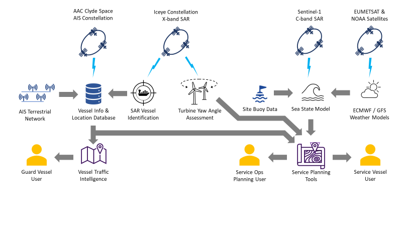
OSCAR will provide situational awareness for maintenance ship operators with met ocean data, weather forecast and vessel tracking data. The service will monitor wind farm site vessels, using AIS and SAR, and yaw misalignment of the wind turbines. By combining these various Earth observation datasets with ancillary data required for wind farm management within a decision-making platform, OSCAR will provide a service that offers benefits over existing products on the market. The solution will drive efficiency, improve productivity, and promote improved safety of operations.
The distance to shore of modern wind farms continues to increase with rough seas and longer journey times making work extremely demanding. The logistics of construction and maintenance of offshore infrastructure is also very complex. To effectively plan for construction and O&M activities, accurate weather, vessel management and tracking, and met ocean data is required. The OSCAR solution will not only capitalise on an unserved need within the market but will open a gateway of potential applications for a single use platform which utilises real-time space-data coupled with complimentary datasets for greater informed decision making for remote renewable operations.
Users and their needs
Key customers or end users of the OSCAR system are offshore wind farm developers and operators. Stakeholder feedback on the issues faced in managing offshore wind farms will feed into the development of the service.
They are faced with several challenges with the current data streams available for weather and met ocean parameters, one such challenge is the significant financial cost. OSCAR will aim to improve the resolution of the data as well as reducing costs to access the data.
Together with planning information, including met ocean data, weather forecasts and vessel tracking, OSCAR will ensure safety of operations and reduce maintenance costs by ensuring the idle time of vessels is limited as well as minimising turbine downtime to provide more yield from turbines and maximise revenue generation.
Safety of operations, for staff and equipment, is an important consideration for operators. During construction, assets and associated vessels are vulnerable to accidental damage caused by other maritime users, this is particularly pertinent during the period where cables are being laid and connected. Site security and resilience are therefore also key issues. Current means of tracking maritime vessels within the wind farm consist of installing a radar system on the turbines and by patrolling the area with guard vessels. OSCAR will create a service to track offshore vessels which have the potential to damage assets within the wind farms and will offer lower CAPEX as no radar is needed on the turbine.
Service/ system concept
Space Added Value
By combining the various space based EO datasets with ancillary data required for wind farm management within a decision-making platform, OSCAR will provide a service that offers benefits over existing products on the market. Synthetic Aperture Radar (SAR) provides satellite imagery that is particularly well suited to the maritime domain, can penetrate clouds and is sensitive to sea state conditions. This can be combined with messages captured from vessel AIS transmissions to provide comprehensive situational awareness across wind farm sites. Weather forecast data will also be used that incorporates observations from meteorological satellites.
Current Status
The demonstration is complete and the FREP has been issued with Status: Final (01/09/2025). A cloud-hosted OSCAR service with an ESRI-based web interface was implemented and exercised with end users. The SeaState component was validated at RWE’s Galloper Wind Farm using multi-year measurements, achieving accuracy suitable for day-to-day planning (wind RMSE ~4 m/s at hub height; wave RMSE ~0.5 m).
Across the pilot, the team processed >1,100 Sentinel-1 scenes and maintained a high successful processing rate. Seasonal analysis showed strongest performance in spring/summer and higher error in winter; recommended enhancements include seasonal bias correction, improved roughness/stability handling for winds, and automated scene quality flags. A dark-vessel detection algorithm reached MVP status but is not released as a production feature in this iteration; turbine yaw misalignment was not developed in this phase.
PR/marketing activity is anchored on the Galloper case study (white paper, KPI visuals) and event outreach (e.g., Global Offshore Wind, WindEurope), complemented by targeted webinars and time-boxed trials for shortlisted users. Operational readiness actions include scaling cloud infrastructure, strengthening support processes, and adopting customer success tooling to meet SLA commitments as the service moves from pilot to paid deployment.
Prime Contractor(s)
Subcontractor(s)