
Ithaca
Via Pier Carlo Boggio 61
10138 Torino TO
Italy
AMPHITRITE
Avenue Coriolis, X-Novation Center, Ecole Polytechnique
91128 Palaiseau
France
New Awake.AI Marketplace set to revolutionise the Maritime Port Services Trading Landscape
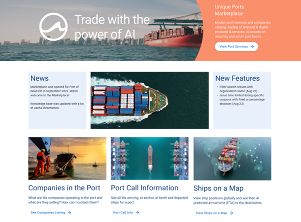
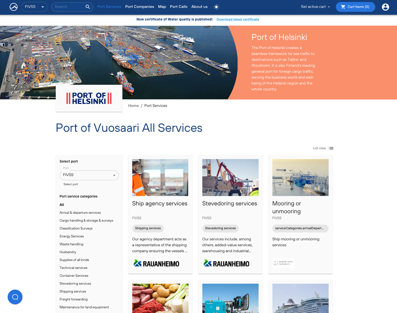
Awake.AI Marketplace, a virtual multi-sided marketplace, is set to transform the way port services are traded. With this innovative platform, port service providers and users can interact, list, purchase and deliver a wide range of port services, both physical and digital.
Developed under ESA’s Business Applications and Space Solutions (BASS) programme and designed to enhance transparency and streamline operations, Awake.AI’s Marketplace empowers port service providers to effortlessly create and manage orders for all types of port services, whether they are connected to a vessel port call or not. For example, shipping agents, acting as buyers, can conveniently browse and purchase these services, while enjoying complete visibility throughout the fulfilment process, including the facility for buyers and sellers to chat.
Awake.AI’s first commercial customer for the Marketplace is Fintraffic, the body responsible for controlling and managing Finland’s land, air and sea traffic. Awake.AI will provide the Marketplace buying functionalities to the forthcoming European Maritime Single Window for Finland through API integrations. This combination of International Maritime Organization (IMO)-mandated new Maritime Single Window & Marketplace functionalities opens up an exciting opportunity for the world of shipping to automate all the buying and selling of port services and products globally.
Simo Salminen, VP of Product at Awake.AI said "We are thrilled to introduce Awake.AI Marketplace, the next-generation platform revolutionising the maritime port services trading landscape. We are very grateful for the support we received from ESA’s BASS programme, which has helped shape our initiative and without which we would not have been able to deliver our vision of a streamlined marketplace for port service providers and buyers. We are now able to offer them a solution which enhances transparency, efficiency and collaboration across multiple essential transactions. We can now envision a future where trading port services are further automated to increase efficiency, with situational awareness and the capacity to adapt & keep all in synch when things change, ultimately driving growth in the maritime industry."
Davide Coppola, Head of the Space Applications Initiatives Section at ESA, said “This has been an important collaboration for ESA and we are excited to see the impact of the new system as it is rolled out across multiple ports. We are confident this new platform will be key in delivering the IMO’s new Maritime Single Window requirements and it has the potential to transform the management of port services trading in the future.”
A wide range of datasets and streaming data are used to make the marketplace smarter and provide added value. These include satellite weather data, SAR data, vessel AIS data, satellite imagery, and GNSS positional data for locations on ports where often a street address is not sufficient. Other non-satellite-based datasets include vessel images, vessel data, port areas, and port calls data. Machine learning, AI, is also used.
Iiro Ahti, Head of Business Development at South Finland Port Service Ltd, said “Awake.AI Marketplace has useful tools to make the fulfilment phase more efficient, with vessel maps & ETA predictions, chat between the parties and local detailed weather report.”
Speaking about the new platform, Olli Soininen, Programme Manager at Fintraffic, said "The Marketplace offers a valuable innovation and service that enhances our new Finnish Maritime Single Window solution. As shipping agents provide port call information to the maritime single window, they can efficiently place essential port call service orders."
Posted to Hero article section
Posted to Hero article section
Joint EMSA-ESA Workshop on VDES in Lisbon
The European Maritime Safety Agency (EMSA) and the European Space Agency (ESA) invite experts within your organisation to attend a one-day joint workshop on the VHF Data Exchange System (VDES) on 6 December 2023 at EMSA headquarters in Lisbon.
VDES is an extension of the Automatic Identification System (AIS) which is widely used for navigation safety between ships and between ships and shore stations to track and identify vessels. Developed to also work with low earth orbit (LEO) satellites, VDES offers a higher data exchange capacity than that of traditional AIS. This allows for the transmission of larger data sets, which can be crucial for various applications such as real-time weather updates, route optimisation, and other data-intensive services. VDES also supports two-way communication, enabling vessels to exchange not only basic identification and positioning data, but also more complex information. This can facilitate improved communication and data exchange.
The Workshop
This workshop aims to provide insight into the latest VDES developments, including discussions about the joint EMSA/ESA VDE-SAT initiatives. It will also present Member States' perspectives on potential VDES use-case scenarios, regulatory developments, the industry's advances, and future plans for providing VDES services in the maritime sector.
Event information
The EMSA-ESA Workshop on VDES will be held on 6 December 2023 at EMSA Conference Centre, Praca Europa No.4, Cais do Sodre 1249-206, Lisboa, Portugal. The workshop will be co-chaired by EMSA and ESA and will be held in English without translation. An updated agenda can be found attached.
Registration Instructions
Experts are invited to express their interest in participating in the workshop by sending an e-mail to Nil.Angli@esa.int by no later than Monday, 27 November 2023.
Agenda
The agenda for this event is available to download below.
File attachments
Community reference
Posted to Hero article section
Posted to Hero article section
UT3-CESBIO
Rond-Point du Professeur Francis Cambou
31400 Toulouse
France
MyEasyFarm
17 Rdpt de l'Europe
51430 Bezannes
France
Satellite technology powers next-generation air-to-ground connectivity for airborne missions
ATMOSPHERE, a company providing satellite connectivity solutions to the aerospace sector, has developed a pioneering system that brings cutting-edge services to aerial work operators. Created under ESA’s Business Applications and Space Solutions (BASS) programme, the system uses satellite connectivity to offer real-time information exchange and boost flight mission efficiency.
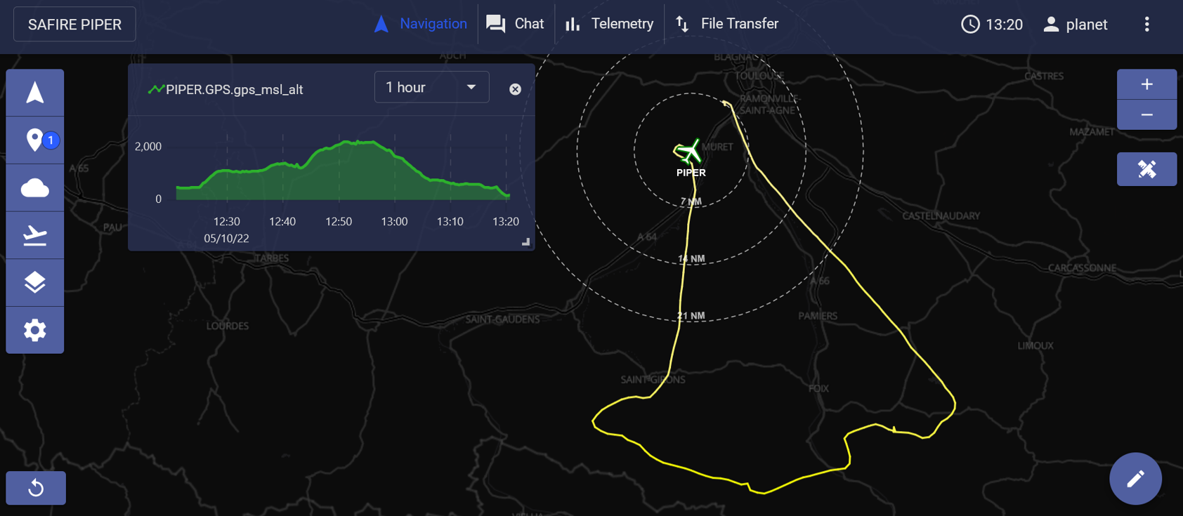
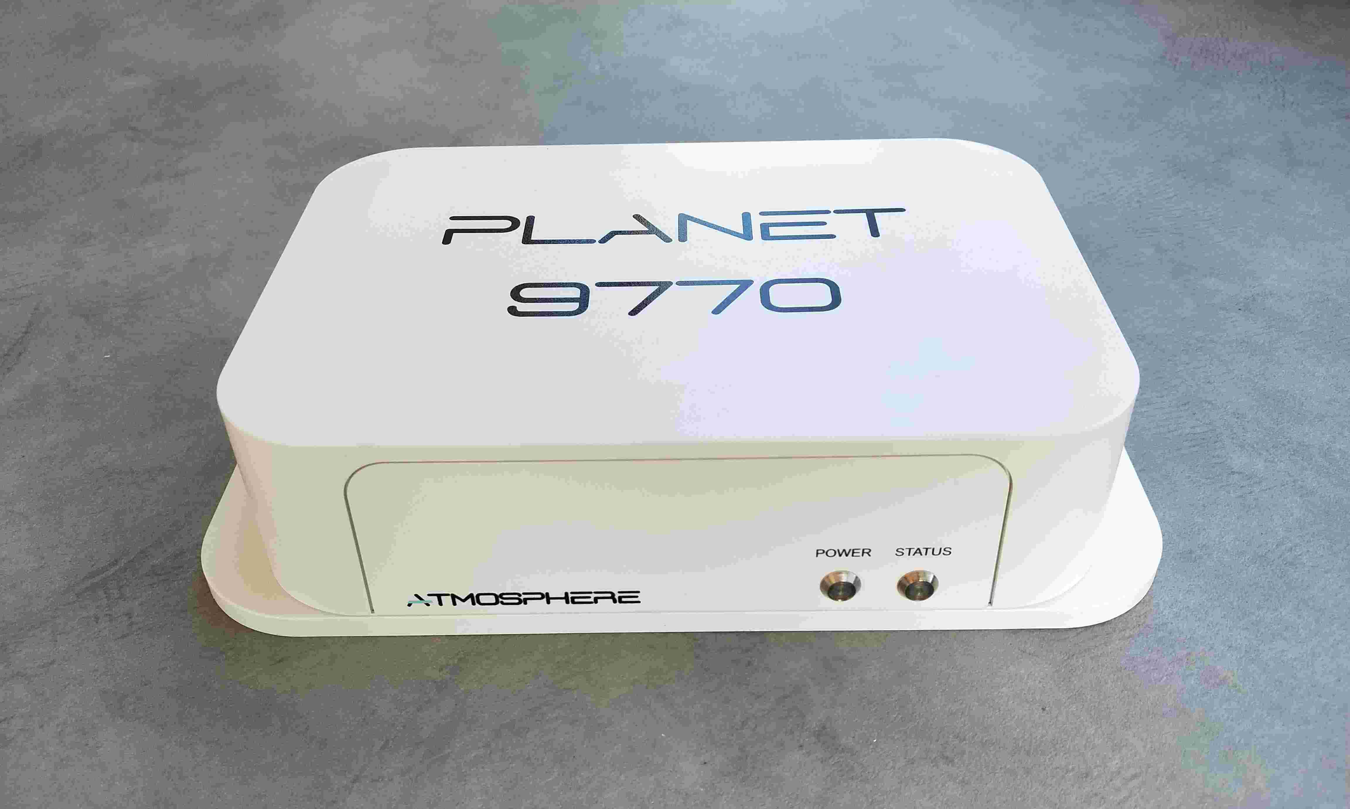
With satellite connectivity constantly evolving, the ATMOSPHERE team identified a need for bringing advanced features and improved performance to aerial flight missions for users. Building on their PLANET service developed under the ARTES Competitiveness and Growth programme, the new system uses satellite communications (SatCom) to take air-to-ground connectivity for aircraft to the next level. It utilises ATMOSPHERE’s PLANET 9770 terminal, which is built around the next-generation Iridium Certus 9770 modem, providing more than 10 times the capacity of traditional terminals.
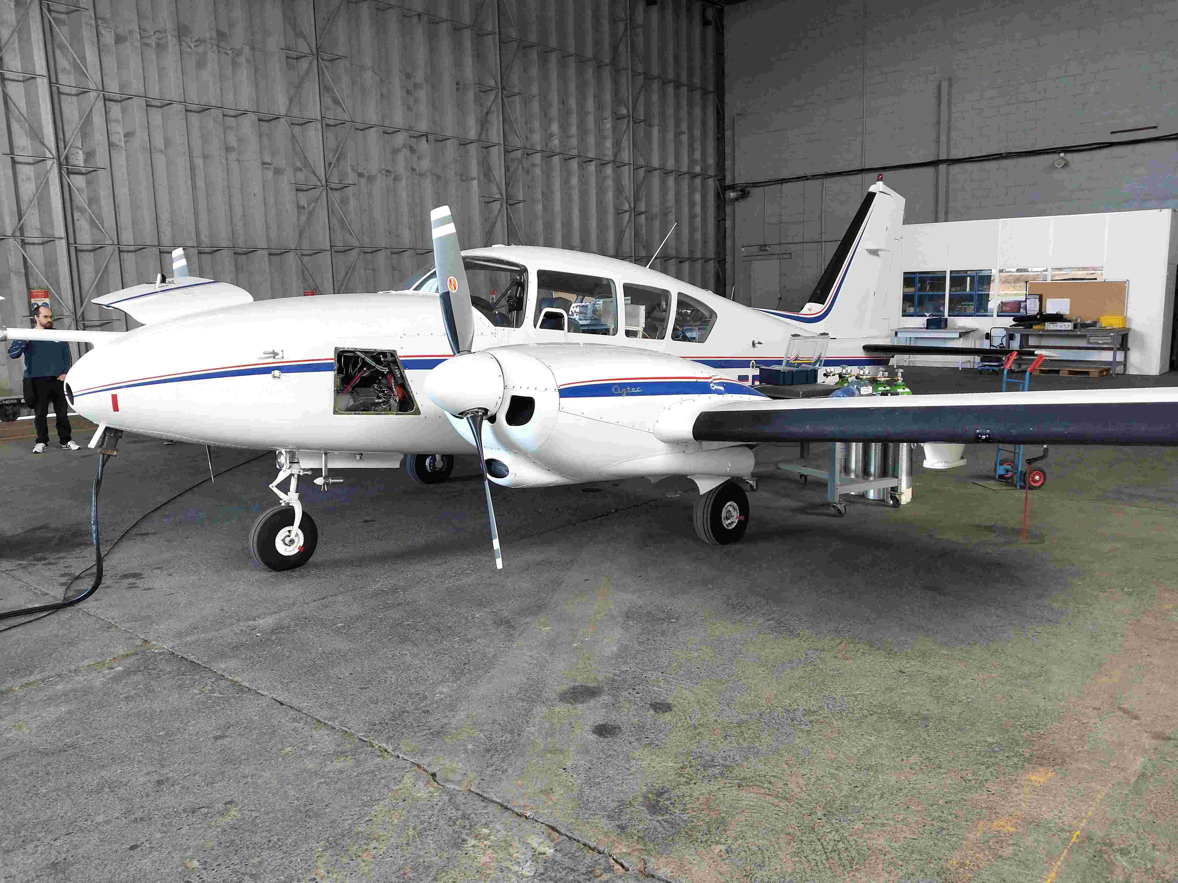
ATMOSPHERE’s latest system can be used to operate diverse platforms, including aircraft, rotorcraft, Unmanned Aerial Vehicles (UAVs) and balloons during special missions, such as flight testing and surveillance flights. The new technology offers bulk on-board telemetry, together with collaboration tools such as tracking, chat functions, geotagging and file transfer, and can support remote operations during single- or multiple-ship missions. The work of the project team also ensured improved service levels, ease of use and alignment with industry standards.
The system consists of two key components: the onboard and the ground segments. The onboard segment’s server links with SatCom and a bespoke inbuilt application acquires and optimises the assimilated data, such as external telemetry. The onboard segment then transmits the data to the ground segment, which stores and presents it to ground users, using APIs (Application Programming Interfaces) to enable the integration of third-party applications.
SatCom plays a central role in the overall system architecture of the service, providing the link between onboard and ground segments during flights and offering global in-flight connectivity. Satellite Navigation (SatNav) provides essential carrier tracking and geo-location, while Earth Observation (SatEO) transmits real-time weather monitoring during operations.
ATMOSPHERE put the new system through its paces, deploying it in pilot operations on fixed wing aircraft and UAVs. The team carried out 14 flights with SAFIRE’s ATR42 fixed wing aircraft, testing system performance and generating early user feedback, and 6 flights on the Dassault F6X, providing further testing of the system at high latitudes. ATMOSPHERE also performed UAV pilot flight tests using multirotors, testing reliability, gaining operational experience and showcasing the new solution.
“ATMOSPHERE’s new system has all the hallmarks of a game-changing solution for aerial flight missions,” said Arnaud Runge, Technical Officer for the project, who also holds a commercial pilot licence. “With ESA’s support, it offers enhanced technological capability, improved performance levels and an array of pioneering features. Alongside the PLANET 9770 terminal, I am confident it will have a significant impact on the sector.”
“ESA’s continuous support was key in delivering mature innovation to the market,” added ATMOSPHERE’s Managing Director, Jean Marc Gaubert. “ATMOSPHERE has been one of the very first to bring Iridium Certus technology to the aviation market. ARTES programme assets, including visibility and credibility, are now translating into business success in Europe and beyond.”
ATMOSPHERE is already established as one of the first companies to achieve certification from Iridium for the PLANET 9770 terminal, with two global reseller agreements already in place and 35 units already sold, and continues to improve and expand its offering. The new system, with this powerful terminal at its core, looks set to transform aerial mission operations for many years to come.
Community reference
Posted to Hero article section
Posted to Hero article section