LLEO Ltd
Main Rd, Plumtree
Nottingham
NG12
United Kingdom

Main Rd, Plumtree
Nottingham
NG12
United Kingdom
Parkside - Birmingham Business Park
Birmingham
B37 7YG
United Kingdom
Münchener Str. 20
82234 Weßling
Germany
A-grid, Otakaari 5
02150 Espoo
Finland
Ilmalankatu 2a
00240 Helsinki
Finland
Automated and autonomous driving depend heavily on different sensor technologies incorporated into the vehicle's sensor fusion engine. For positioning, it’s important to have a range of different technologies for redundancy reasons, including Global Navigation Satellite System (GNSS), which provides absolute positioning based on radio signals to complement visual sensors like cameras.
A partnership between Portuguese space specialist company Deimos Engenharia and Austrian start-up Accurision has created a highly accurate positioning sensor using Europe’s Galileo GNSS system. Galileo provides world-class navigation, offering a natural solution for terrestrial applications, such as sensors for autonomous driving but moving from an initial idea to a practical solution is a complex process.
In 2013, Instituto Pedro Nunes (IPN), ESA Space Solutions Centre in Portugal identified Deimos Engenharia’s GNSS receiver as having exciting potential applications on Earth. Developed specifically for the Galileo GNSS system, it relies on radio signals to better determine a user’s position and time. As a result, the technology was shared across the ESA Technology Broker Network in 16 countries.
Deimos Engenharia had been studying potential applications of this technology, including in unmanned aerial vehicles, for some time. “We wanted to make the most of the unique features of the Galileo system, which is why we decided to develop our own receiver. We needed to master the receiver technology and have full control at its deepest level to develop the product and integrate it in advanced navigation solutions,” remarks Deimos Engenharia Director Nuno Ávila.
Around the same time, Brimatech, an ESA Technology Broker in Austrian, met an entrepreneur searching for high precision satellite-based positioning sensors for autonomous driving.
“Within three weeks of meeting Accurision’s CEO Gunnar Fleisch at a conference, we had eight technology suggestions for him, pre-checked by our ESA network partners. That was impressive!” remembers Brimatech’s Andrea Kurz.
From the proposed space technologies offered, it was the Portuguese GNSS receiver from Deimos Engenharia that best suited the application. "Accurision's product approach is to be 'as robust as possible, as accurate as required'," mentions Gunnar Fleisch, Co-founder and CEO of Accurision.
Accurision is now using the Deimos solution to develop the GUIDANCE™ GNSS Sensor ASIC for autonomous driving. This takes advantage of one of the world’s most advanced civil GNSS signal, Galileo E5 AltBOC, to provide unparalleled robustness while achieving the required precision in dynamic rural and urban environments necessary for autonomous driving. It also features an integrated ionospheric delay estimation engine (IDEE), integrated interference detection and a mitigation engine (IDME) to further improve overall performance.
Accurision’s key aims with the new sensor are robustness, integrity, accuracy and precision. GUIDANCE will be ready to support the upcoming Galileo E6 High Accuracy Service, which will be available free of charge from late this year.
Making this international cooperation happen involved considerable effort. IPN and Brimatech brokered the first meeting between the two parties and supported them to agree and sign a technology transfer agreement, enabling future downstream technical developments.
“Technology transfer is an elaborate activity,” explains Carlos Cerqueira, IPN’s Innovation Director. “Its cornerstone is the fit between technology and market requirements, but in the end what it takes is an excellent relationship with all parties, the ability to spot a need, find a matching offer and get the timing right. With Deimos, it was no different. It took time, but substantial economic impact is just about to happen.”
The partnership between Deimos Engenharia and Accurision teams is a clear example of the power of ESA’s ‘behind the scenes’ network and how a united European approach to space is fundamental to fostering the economies and societies through space technology. In future there will be autonomous vehicles relying on Galileo’s GNSS via the GUIDANCE™ GNSS Sensor ASIC, based on a patent jointly owned by the two companies for their Galileo Code Sensor – all thanks to the far-sightedness and hard work of ESA Space Solutions partners network. To further foster this technology transfer, Accurision received the support of the ESA Business Incubation Centre (ESA BIC) in Austria, where it was incubated. “It is our mission to support ground-breaking business ideas, building on existing European high-quality space capacity,” says Martin Mössler, Managing Director of Science Park Graz, General Manager of ESA BIC Austria.
ESA Space Solutions is the go-to-place for great business ideas involving space in all areas of society and economy. Our mission is to support entrepreneurs in Europe in the development of business using satellite applications and space technology to improve everyday life. Our programme is designed to provide multiple entry points such as ESA Business Incubation Centres (ESA BICs), ESA Technology Broker Network, and ESA Business Applications programme. Funding typically ranges from 50KEuro to 2MEuro and supports everything from space technology transfer, early stage incubation programs, Feasibility Studies to large-scale Demonstration Projects.
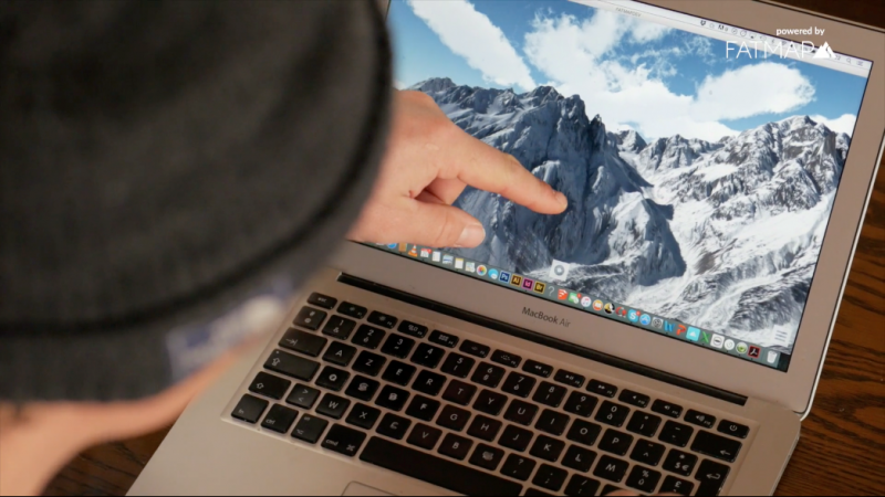
“Better, safer adventures”, FATMAP have boasted since they launched the world's most advanced 3D outdoor map. This adventure platform for web and mobile means hikers, skiers, mountain bikers and trail runners can plan the perfect route, equip themselves like a professional, and then record and share their adventures with the community.
“Whilst explorers of old needed extreme amounts of preparation or often simply strode blindly into the wilderness - at FATMAP we have brought together cutting-edge technologies and local experts to make adventures simpler and safer,” says Marcel Düe, Chief of Staff at FATMAP.
Now with the support of ESA Space Solutions, detailed and contextual live information has been added to the app.
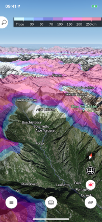
“Having up-to-date data in the palm of your hand even if you don’t have Internet connectivity can make a critical difference in enjoying an exhilarating but safe adventure,” says Francesco Feliciani, Head of the Companies-Led Projects Section at ESA. “The team have made use of a range of satellite data to create new features including game-changing real-time snow conditions such as snow depth, fresh snow and snow forecasts as well as live resort status updates including which lifts and pistes are open or closed.
“I myself am a ski enthusiast and use FATMAP, which has literally saved me a number of times from being stranded at the end of the day in some remote corner of a ski resort I was exploring with my friends.”
The app makes use of data from Earth observation satellites (such as radar-based and high-resolution imagery) to provide the rich digital terrain and surface models producing 3D images as well as the computational mapping overlays including gradient, aspect, flat zones and distance mapping.
“Knowing in advance the type of terrain and conditions helps beginners as well as experienced individuals to plan – making adventures accessible to those who are not experts in reading traditional maps or in the local geography,” says Düe. “Webcams are an easy way to get a rough idea of current conditions”.
The mobile platform allows users to preload the heaviest data chunks. This ensures that an adventurer who is already outdoors only has to download a small percentage of the overall dataset in order to have access to the most up-to-date information, displayed in a rich 3D context.
Adding these live features was not without hurdles as the team had to obtain access to local data and then harmonise different data sets in coverage in order to update both the cycle and display. “Ultimately the aim was to be able to offer a consistent user experience based on inconsistent and sparse data. Thanks to ESA’s support we have achieved this,” says Düe.
Future plans for the global FATMAP platform include the incorporation of more data sets with easier ways for users to contribute; to be rolled out in 2021.