Objectives of the service
STELLAGRI addresses a key need in agriculture: access to reliable, large-scale and up-to-date information about crops. Satellite analytics provide this by enabling continuous monitoring of entire fields, delivering objective data on crop condition, risks, and yield potential without the need for on-site inspections.
The system automatically transforms satellite imagery into clear, ready-to-use insights and delivers them directly into user systems. This allows both large companies and small farmers to make faster, better decisions, reduce manual work, and gain full visibility of their crops throughout the season
Users and their needs
STELLAGRI targets two primary user communities in Poland and other European Union countries.
Corporate users (CORP): large food production and processing companies managing hundreds of contracted fields (e.g. potato and vegetable processors). SME users (SME): small and medium-sized farms, including fruit growers and orchard owners, often operating on areas below 5 hectares.
These users are directly involved in the activity through testing, validation, and feedback using real operational data.
Key user needs and challenges: · Lack of independent, reliable crop data without relying on growers to verify growers’ compliance with contracts (CORP) · Limited visibility of crop quality, stress, and yield risks across all fields (CORP, SME) · Time-consuming and costly field inspections with low coverage (CORP, SME) · Challenges in identifying crop types and estimating production at scale (CORP, SME) The project addresses these needs by delivering automated, ready-to-use satellite analytics integrated directly into user systems or accessible via a platform. A key challenge is ensuring seamless integration across diverse systems, maintaining high data accuracy, and providing accessible, cost-effective services for both large enterprises and smaller farms.
Service/ system concept
STELLAGRI provides automated crop intelligence based on satellite data, delivering ready-to-use information on crop condition, stress, growth, and crop type. Users receive processed maps, alerts, and field-level insights that cover entire areas rather than limited samples, enabling a complete and reliable view of production.
The service automatically matches satellite data to specific fields and crops, eliminating manual data collection and integration. Results are delivered directly into existing systems, such as enterprise platforms or cropchart.net, or accessed through a simple web interface. Users can monitor all fields continuously, detect risks early, estimate yields, verify field locations, and identify crop types across regions.
Key functionalities include automated data delivery, full-field monitoring, early warning alerts, and multi-season crop recognition. The system also enables benchmarking across farms and supports planning, logistics, and contracting decisions.
When deployed, users gain the ability to manage large numbers of fields with minimal effort, reduce operational costs, and make faster, data-driven decisions. The service is accessible to both large agricultural companies and small farms, including those operating on very small areas, providing advanced capabilities previously unavailable to them.
Space Added Value
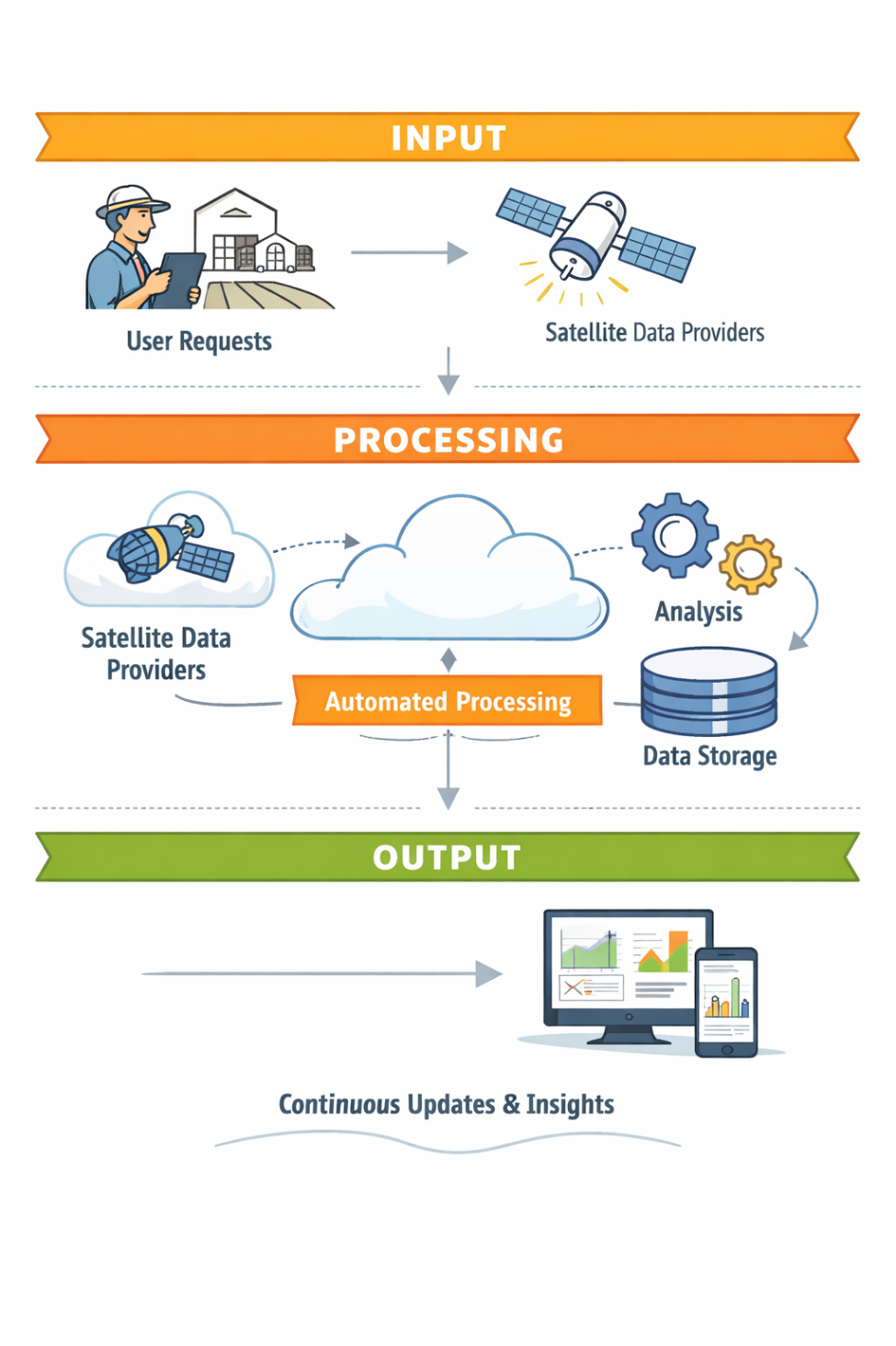
STELLAGRI uses multiple Earth Observation (EO) satellite assets, combining optical and radar imagery from providers such as Sentinel, Planet, Kompsat, Maxar and Umbra. These sources deliver frequent, wide-area coverage at different resolutions, enabling continuous monitoring of crops across large and small farms.
Satellite data is transformed into practical information, including vegetation condition indicators (e.g. crop health and stress), crop type recognition, field boundaries, and early warning alerts. By combining data from multiple satellites, STELLAGRI improves reliability, reduces gaps caused by cloud cover, and increases accuracy of crop analysis.
Compared to current methods such as field inspections, drones or in-field sensors, satellite-based monitoring offers significant advantages. It does not require on-site presence, covers 100% of fields instead of limited samples, and enables regular updates throughout the growing season. It also avoids the cost and complexity of maintaining physical equipment.
The added value of STELLAGRI lies in combining satellite data with automated processing and delivery. Users receive ready-to-use insights directly in their systems, without manual work. This allows them to monitor large areas, detect risks earlier, and make faster, more informed decisions than with existing solutions.
Current Status
During the recent project period, the STELLAGRI team continued the implementation andintegration of the platform’s core services. Development of AI-based crop recognition and EarthObservation data processing workflows remains in progress, while the technical infrastructurehas been completed. The end-to-end ordering workflow is close to completion, service configuration is ongoing, andthe pricing mechanisms and access to additional Earth Observation data sources have beencompleted. The Alpha release is expected to be ready for demonstration at the World Agri-Tech InnovationSummit in London. The next activities will focus on platform integration, further development of AI-based croprecognition, and completion of the remaining ordering and commercial functionalities,supporting preparation for the Factory Acceptance Test (FAT).