

TEst
Hello
This is the
kjhkjh
Assessing insurance risk and damage in the digital age
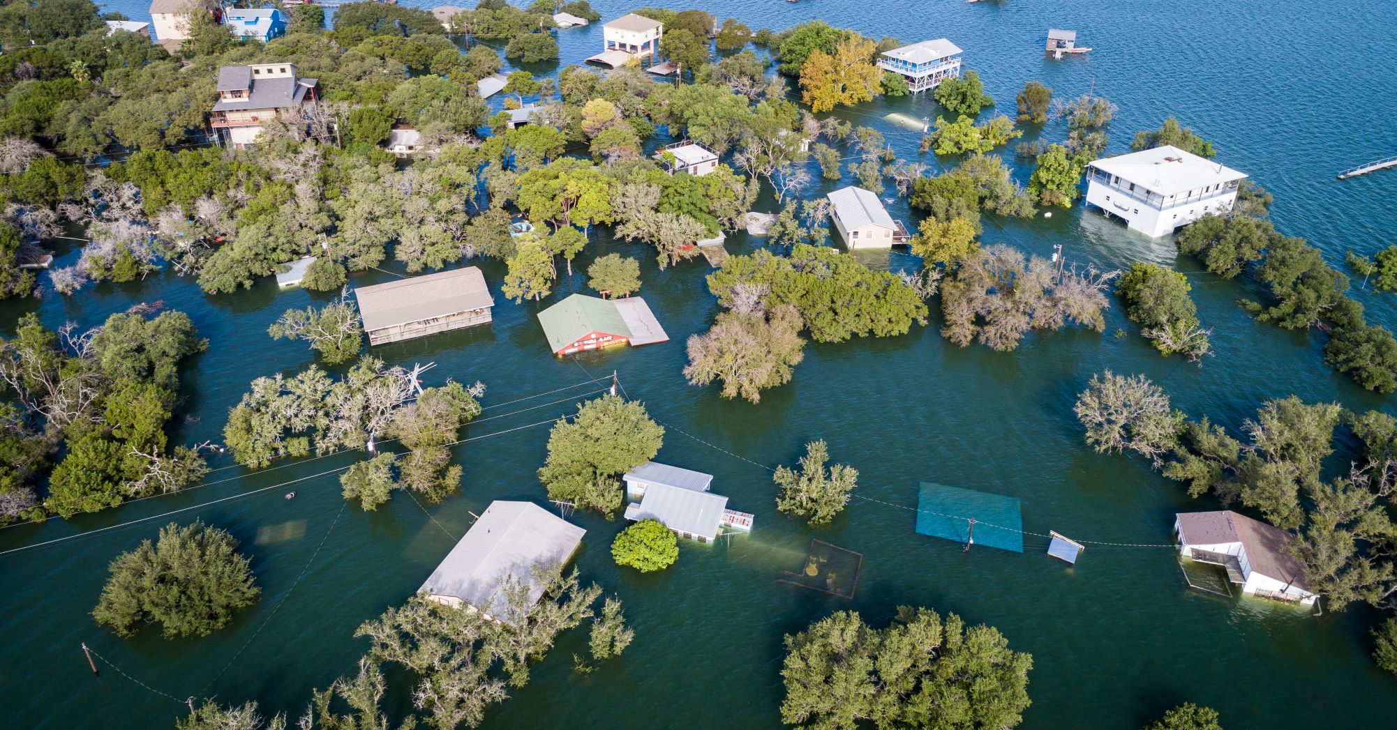
McKenzie Intelligence Services (MIS) has recently launched a Global Events Observer (GEO) for the insurance industry. GEO amalgamates highly accurate geotagged data from a range of sources to identify and track damage to property and infrastructure caused by catastrophes such as natural disasters. The technology was developed with co-funding from the ESA Business Applications Programme.
Accurate insurance assessment has traditionally meant sending a person to the site. This is expensive, and in the case of natural disasters such as flooding, hurricanes, and earthquakes, physical access to the risk location may be limited and/or hazardous. That’s why the (re)insurance industry has long been calling for better real-time damage intelligence and analysis after catastrophic events.
Responding to that need, MIS, with support from ESA, developed GEO. It combines high quality real-time data from space and ground-based sensors, including optical satellite images and radar, to provide detailed monitoring during and after catastrophic events. It also houses historical data for every global peril since 1979, providing valuable pre- and post-event comparisons. These capabilities combine with the on-the-ground insight and artificial intelligence programmes used by MIS to analyse the data.
Volker Schumacher, Business Applications Engineer at ESA said: “MIS approached us in 2018 looking for support to enhance capabilities for identifying and tracking damage to property and transport infrastructure. GEO is a prime example of what can be achieved if globally available satellite-based Earth observation information extraction is automated and harnessed.”
The GEO platform enables insurers to allocate the most-effective resources to deal with an event with multi-source intelligence. Historically done with modelling, insurers can now use real-time space data and aerial imagery to overlay crucial data and identify hotspots in a catastrophe. This allows the insurer to analyse the extent of the damage and assess the areas of most in need, ultimately resulting in a quicker tactical response in terms of reserving funds, managing claims, underwriting and operations.
An invaluable real-time resource for customers
The benefits of GEO were seen in practice during Hurricane Ida in September 2021, which was one of the strongest storms to ever hit the US mainland. MIS was able to use GEO to provide an invaluable, enhanced real-time resource for customers.
Forbes McKenzie, CEO of MIS commented: “For the insurance sector, the applications of GEO are game-changing. Once a trigger event happens, MIS sends data to the client system and they act upon it in either their exposure management, claims or other workflows, greatly speeding up these workflows and providing very accurate data from the ground. For parametric policies, which provide pre-specified payouts based upon a trigger event, the benefits are multiplied. We envision far-reaching development and increased relevance of parametric insurance in the months and years to come as a result of initiatives like GEO.
“We are really delighted to have received funding from ESA Space Solutions for the GEO and are grateful for the operational and demonstration support the experts at ESA are providing. Working closely with the team also helps us keep abreast of the latest developments in space technology, ensuring we build a service to customers that delivers value today, but remains fit for the future in this ever-evolving space.”
Helping insurers support their customers during periods of crisis
A further significant development for MIS came in September 2021 when Lloyd’s of London announced a two-year partnership with MIS. The agreement provides the Lloyd’s market with access to multi-source intelligence through the GEO platform, which will help deliver faster claims decisions and payments for customers, and supports the ambition set out in the Future at Lloyd’s Blueprint Two to build the world’s most advanced digital and technology led insurance marketplace.
Posted to Hero article section
No
ESA and PSCE cooperate on Space Applications and Digital Transformation in Public Safety
The European Space Agency (ESA) and Public Safety Communication Europe (PSCE) are working together to support the emergence of space-based applications in the domain of public safety. Having jointly signed a Memorandum of Intent (MoI), the organisations will join efforts to support the emergence of applications that leverage on secure satellite communications for addressing the needs of blue forces. ESA will launch a funding call early in 2022 to invite companies to develop and demonstrate digital services that are enabled by secure satcom solutions for addressing the urgent needs of public safety operators.
Security in space and on Earth are inextricably linked. The deployment of advanced satellite systems and their safe circulation in space are crucial for resilient and secure connectivity on Earth. As set out in its recently released vision for European space activities, ESA is stepping up its efforts to enable Europe to address new safety and security user needs to make sure that our space programmes continue to be at the service of all citizens through Agenda 2025. ESA's Strategic Programme Line “Space Systems for Safety and Security (4S)” combines both to include applications within disaster preparedness, response and resilience, situational awareness, assessments of damages, navigation-based services for tracking and coordinating rescue forces on-site and for emergency vehicles.
Through its ARTES (Advanced Research in Telecommunications Systems) programme, ESA is forging strong links between institutions, industries, and business to leverage the capabilities of space to drive digital services.
“I’m pleased to be working with PSCE to realise the potential of space to drive commercial solutions for secure satellite communication in public safety. This is a great example on how ESA is promoting the use of space technologies and applications to address safety and security needs expressed by the organisations operating in this domain. This collaboration will pave the way to the ESA Rapid and Resilient Crisis Response (R3) Accelerator,“ says Rita Rinaldo, Head of the Partner-led and Thematic Initiatives Section, ESA Space Solutions.
Call For Proposals
ESA and PSCE will launch a call for proposals in Q1 2022. It will invite companies to submit proposals for demonstration projects showcasing the value of innovative space-based downstream services and solutions in the public safety domain. The services shall demonstrate innovation in connection to enhanced secure communications in combination with the ongoing digital transformation, which has allowed the opening up new opportunities for the public safety sector, leading to the emergence of new concepts and solutions to tackle safety and security challenges with innovative solutions. Solutions are expected to address the needs identified by public safety stakeholders including fire brigades, law enforcement, emergency services, and civil protection. The projects will be co-funded through the ARTES 4S and Space Solutions programmes of ESA.
“We are very happy to cooperate with ESA to help address the challenges public safety stakeholders face through improving secure satellite communication. We are looking forward to the proposals,“ says Monika Büscher, President of the Board of the PSCE Forum.

Posted to Hero article section
No
FieldSense
Agro Food Park 13
8200 Aarhus
Denmark
CGI IT Czech Republic, s.r.o
Londýnské nám. 881/6
639 00 Brno-střed-Štýřice
Czechia
ORCA
Bryghusgade 8, 3
1473 København K
Denmark