Space to Subsea
May, 29 / 2026

May, 29 / 2026

Space technologies are playing an increasingly central role in strengthening resilience across infrastructure, climate, mobility and supply chains. These themes were at the centre of discussions at the Economist’s Space Economy Summit Europe in Lisbon earlier this month, where ESA’s Business Applications and Space Solutions (BASS) team, together with ESA’s Strategic Sustainability Team, joined industry leaders, investors and policymakers. Discussions covered everything from AI and geopolitics to investment and regulation, but one message emerged consistently throughout the event: the challenge facing the space sector is no longer technological capability or access to data, but adoption and implementation.
Rita Rinaldo, Head of Applications, Projects and Studies Division at ESA, during her intervention in the fireside chat ‘Beyond rockets: how space underpins Europe’s economy and society,’ underlined that “according to projections, the space downstream sector exceeds three quarters of the worldwide space turnover, which is growing at a rate increasing 10% CAGR. While being a major playing field for European space companies, there is an impellent need to increase efforts to raise more awareness of the value of space as competitive enabler for many economic sectors and how it supports Industry competitiveness.”
“Limited awareness of space capabilities have led to fragmentation across the value chain, meaning that whilst solutions exist, they often do not reach the users, with this lack of coordination leading to lost opportunities for growth’ continued Ms Rinaldo. “This was identified as a critical bottleneck to scaling uptake.”
BASS has partnered with multiple market sector leaders to strengthen cross-sector cooperations and facilitate scaling of space-based solutions. The recent launch of the Task Force “Space for Logistics and Resilient Infrastructure” in March 2026 complements the BASS Task Forces already working on energy, maritime, bioeconomy and smart cities and will boost the opportunities that we are offering to European companies exploiting space to address the many sector challenges.
 During the event, Rita Rinaldo and Liz Barrow, Business Applications and Partnerships Officer at ESA, hosted an interactive roundtable session, ‘How space technologies can help mitigate threats to society,’ bringing together stakeholders to explore how space-based technologies can support resilience (particularly in climate, infrastructure and supply chains). Space is no longer seen as a standalone industry, but a critical layer of economic and technological infrastructure underpinning modern society. During the conversation, a number of recurring themes emerged. These included:
 Andrea Vena, ESA Chief Sustainability Officer, was part of the ‘Responsible in orbit, sustainable on Earth: can space power Europe’s climate transition?’ panel at the event. With Europe already placing responsible space activity as central to its policy narrative, and satellite data already feeding into pilot projects in methane detection, deforestation monitoring, grid resilience and flood-risk mapping, the focus of the discussion was again around implementation and how to integrate this into core climate infrastructure to drive improvements at scale.
“Space technologies are crucial for increasing our knowledge, monitoring our planet and delivering key benefit to the sustainable development of society. Therefore, we must preserve the possibility for future generations to benefit from space by making space systems more sustainable and respecting the environments (Earth, Earth’s orbit, and deep space) they are impacting,” said Mr Vena. “Europe is leading this ambition, making responsible space activities central to its policy, with key actions enabling the European space ecosystem to be sustainable and competitive on a global scale, maximising benefits to society while reducing the space sector's environmental impacts.”
The view that the future growth of the space economy will depend less on generating new data, and more on making space-enabled services accessible, integrated, sustainable, and operationally relevant across the wider economy was a key takeaway from the Summit.
“Space is increasingly positioned as core economic infrastructure,” said Liz Barrow. “Across sessions, space was framed as an enabler for mobility, finance, communications, security and resilience—no longer a niche sector, but embedded in wider economic systems.”
“We know what the problems are and we know how to solve them. All we need is unified action.” Few voices carry greater authority on the state of our planet than Sir David Attenborough, who celebrated his 100th birthday this week, a fitting time therefore for ESA’s Business Applications and Space Solutions (BASS) team to bring key stakeholders from across Europe together at ESTEC in the Netherlands for the BASS Water Day.
The event provided an opportunity to address some of the most pressing global water challenges - including water scarcity, water pollution, climate change, and growing resource pressures – while showcasing the wide range of innovative space-enabled solutions being developed through BASS projects. The event also marked the opening of the new Digitalisation of the Water Sector call, inviting proposals for water-related innovations for proof-of-concept studies and pilot projects.
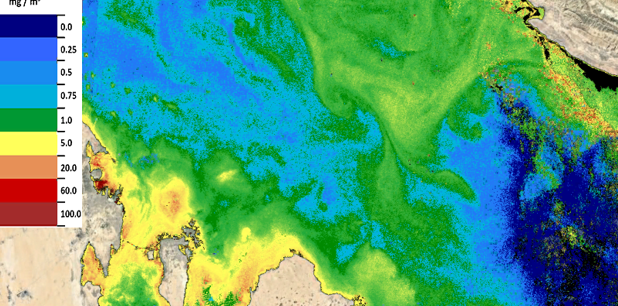
 The statistics around water are stark. According to the United Nations, roughly half the world’s population face severe water scarcity for at least part of the year, 2.1bn people live without access to clean drinking water and 3.5bn do not have access to safely managed sanitation. All this against a backdrop of increased demand, diminishing supply and increased frequency and severity of droughts and floods as a result of climate change.
The day was organised by Beatrice Barresi, Senior Sustainability Officer for ESA and Bioeconomy lead at BASS, who set the scene for the day with her opening remarks. Rita Rinaldo, Head of Applications, Studies and Projects Division at ESA, followed with a welcome address where she outlined the important role space has to play in the future of water management.
“Satellites offer an unparalleled view of our planet, enabling us to observe and monitor not only water but all natural habitats, and contribute to sustainable and resilient life on Earth in many ways” said Ms Rinaldo. She also outlined the contribution of BASS which has so far invested almost €200 million in successful projects delivering tangible green impact. The BASS programme has supported companies in delivering innovative and ambitious business models that have led to the creation of 1,649 partnerships across multiple sectors, helping drive innovation to address some of the world’s most pressing challenges - including those linked to water.
Collaboration and shared action emerged as key themes throughout the event, building on discussions held during the Bioeconomy Task Force meeting the previous day. “The importance of cross- sector collaboration has motivated us to engage with key stakeholders and market leaders” continued Ms Rinaldo. “The call on Digitalisation of the Water Sector has been shaped through partnerships with the members of the Bioeconomy Task Force, covering the needs expressed by key players in several industrial sectors.”
This commitment to partnership working was reflected in the diversity of participants and panellists, who included representatives from industry, city authorities, utilities, research organisations, environmental groups and international networks.
Designed to encourage discussion and collaboration, the programme for the day featured five panel sessions focused on the sector’s most urgent challenges and the potential role of space-enabled solutions in addressing them. The opening session, Securing Sustainable Water, focused on challenges facing agriculture and forestry. Marion Karmann, Senior Research Relations Manager at FSC International, highlighted the close relationship between forests and freshwater systems, saying
“With 75% of accessible fresh water sources coming from forested land, we need to maintain and conserve our forests as a priority.”
According to UN data, agriculture accounts for around 70% of global freshwater withdrawals. ESA BASS is currently supporting a wide range of agriculture-related projects aimed at reducing water consumption and improving sustainability through innovations in irrigation, pesticide management and soil monitoring.

The second panel, New Thinking on Water Resilience, explored the challenges facing water infrastructure and supply systems. Participants highlighted the lack of reliable and integrated data as a major barrier to improving resilience and ensuring safe, continuous access to water services. “Water is a service that must be provided in the right volume, of the right quality, at the right time and at a fair price across the world,” said Andrea Rubini from Water Europe. This view was echoed by fellow panellists Julie Marechal Perkins from Global Water Operators’ Partnerships Alliance and Georgios Sachinis from EYDAP, who discussed the importance of stronger coordination and consolidation of water utilities in countries facing the highest risks of water scarcity.
While the panels highlighted the scale of the challenges ahead, the event also showcased a wide range of innovations being developed to address them. During the networking lunch, participants had the opportunity to meet companies contributing to the event’s poster session and discuss projects covering areas such as water monitoring, environmental intelligence, infrastructure resilience and sustainable resource management.
The afternoon programme featured three further panel discussions covering Scaling Innovation in Cities, Unlocking New Sources of Finance for the Water Sector, and Protecting our Oceans. Across all sessions, participants returned to common themes: the importance of data-driven decision-making, the need for collaboration across sectors and borders, and the growing role of innovation in supporting more resilient and sustainable water systems.
Closing the event, Nick Appleyard, Head of ESA’s new ACCESS programme, said “Water is essential to life on Earth and the challenges – not enough water, too much water, and water quality – are increasing. This is the first Water Day we have held at ESA and I hope it will be the first of many, as we work together in looking to space to find innovative solutions to these challenges.”
Dr Appleyard continued “Our Digitalisation of the Water Sector call opens today and I hope that many of you here will be inspired to submit your proposal over the coming weeks.”
Read more about the Digitalisation of the Water Sector Call
Sign up for our Bioeconomy Bulletin