eLEAF BV
Hesselink van Suchtelenweg 6
6703 CT Wageningen
Netherlands

Hesselink van Suchtelenweg 6
6703 CT Wageningen
Netherlands
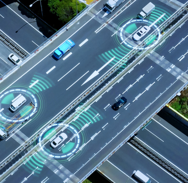
The thematic call “Satellite Connectivity for Autonomous land vehicles safety” aims to foster the development and showcase of innovative applications for the safe and secure deployment and management of autonomous and connected land vehicles by integrating satellite communications and other space assets with terrestrial and digital technologies.
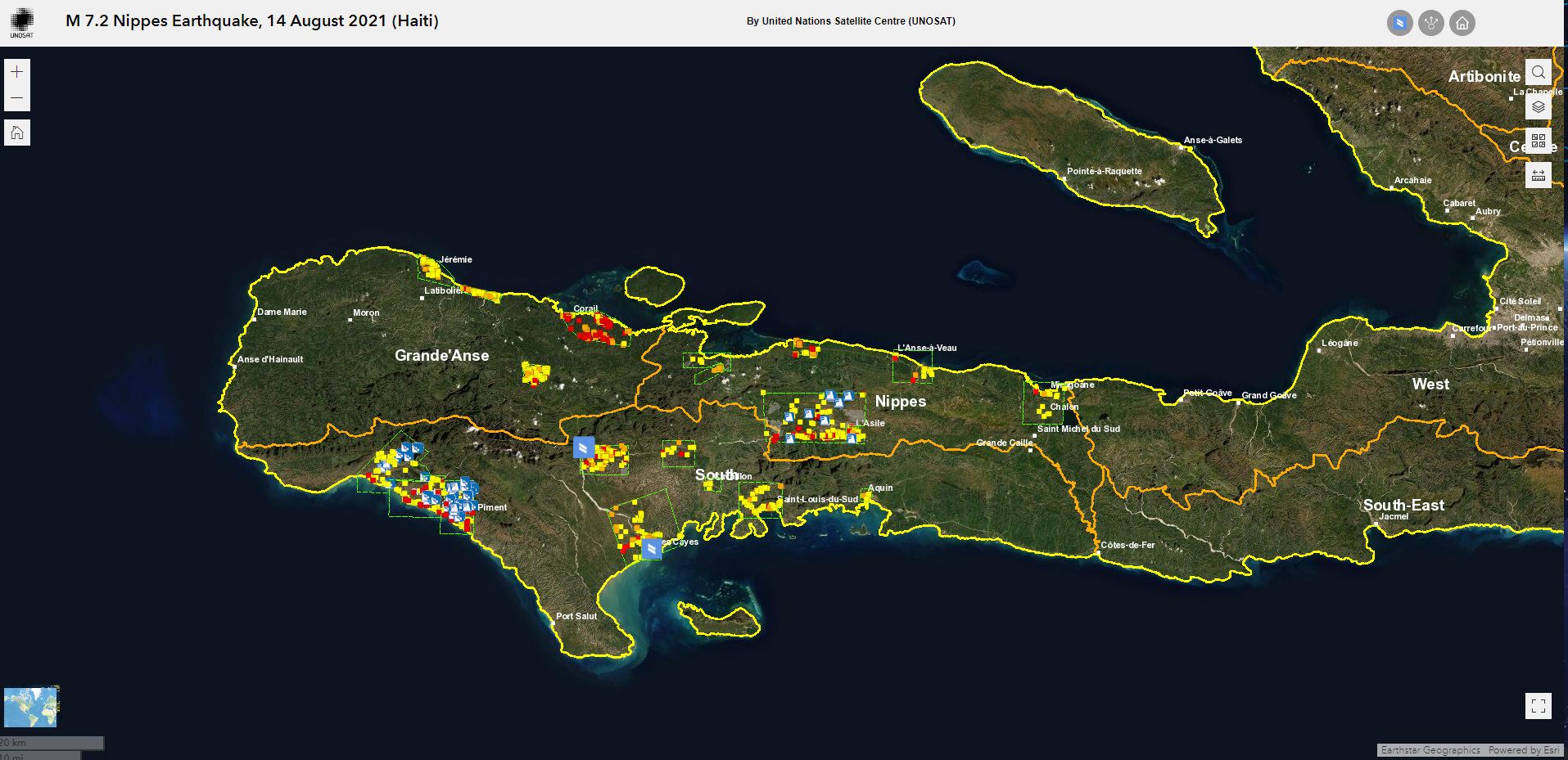
The United Nations Satellite Centre (UNOSAT) launched its Humanitarian Rapid Mapping service in 2003, using satellite imagery to monitor natural disasters such as earthquakes, forest fires and floods. The intention was to use satellite images to direct first responders and medical teams to where they were required. These early satellite images were provided as PDFs which, while useful, could not be easily updated.
Meanwhile in Norway, a small tech company, AnsuR, had launched ASIGN, an application which could operate via satellite and mobile phone technology using very low bandwith, ideal for when networks fail in the aftermath of a disaster. UNOSAT realised that ASIGN, if run on smartphones, could help them amend their satellite images in real time, so teams on the ground had a constantly updating, georeferenced resource. Live, online maps were a huge boon to disaster relief and, as a consequence, AnsuR won ESA’s App challenge, part of the Copernicus Masters competition for global innovation, in 2012.
Subsequently, working with UNOSAT and ESA Space Solutions, ASIGN was developed further. A pilot demonstration in South-East Asia – an area exposed to more natural disasters than any other part of the world – led to the launch of B-SURE or “Benefiting from Space for Urban Disaster and Resilience Excellence”.
B-SURE’s main objective is to further minimise disaster response time. Bandwidth usage has been reduced even further, by up to 99 per cent, saving time while data is transferred. It is particularly suited for disaster and emergency management because if no local mobile network is available, it can use satellite channels instead. First responders can communicate efficiently whatever the situation.
“AnsuR has been dedicated to apply our innovation in mission-critical communication to humanitarian operations, and in particular with the UN and UNOSAT, almost since we were founded. With B-SURE we have managed to develop several new technical capabilities that provide new services that in term help UN operations become more effective. Working with UN provides us with a chance to test and validate our solutions in tough situations. In turn, this also gives us credibility when working with other user groups. Solving these kind of substantial challenges with the UN is also highly motivating for our team to work with,” said Dr Harald Skinnemoen, Founder of AnsuR.
Information managers interact with users in the field using online web browsers on secure servers, with information sent directly to the responders’ smartphones. The managers can study data from Earth observation satellites, locally based drones and video taken at the scene, and select high-resolution images where they are required, enhancing field operatives’ knowledge on the spot. Satcom information can be used to direct them to where they are most urgently required.
The Unmanned Aerial Vehicle (UAV) version of the software allows remote viewers to directly access camera footage from drones flying over the disaster scene, while video conferencing between managers and teams on-site is also an option. Individual members of the public affected by the situation can also contribute by uploading photographs or video they have taken. ASIGN prioritises the network capacity of content it considers most relevant and filters incoming data.
The COVID pandemic halted development of the programme briefly but B-SURE has since been used to direct the response to the 2021 floods in Germany, and UN peacekeeping forces have issued a tender for procuring the system. The system is installed with the UN at the CERN campus, where the World Wide Web was invented. Using the world's first web-domain (cern.ch) The UN OCHA (INSARAG) has adopted the system to direct response teams during emergencies. The Oslo Police have also installed the system on own servers for security use cases.
“UNOSAT has supported AnsuR in the B-SURE project because the technology developed supports several of our sustainable development goals, such as Goal 9 for innovation and building resilient infrastructure, Goal 11 for building more resilient cities able to cope with disasters, Goal 13 in handling natural disasters that are effects of climate change and Goal 17 in creating partnerships for achieving the goals,” said Einar Bjørgo, Director at UNOSAT. “UNOSAT and AnsuR has a long relationship spanning more than a decade. The highly successful results of the B-SURE project, proven on multiple occasions in the field, allow the UN to provide new and more innovative satellite-based solutions that ultimately help UNOSAT provide better services to the UN and to the world in general.”
Schools have always played the role of catalysts of innovation and creativity. They are the place where students explore, often for the first time, new technologies and advanced solutions. The advantage of technologies and innovation in the education sector is twofold: students are accompanied and prepared to enter the world of work, and they also become an essential tool for enhancing the quality of teaching and the learning process, especially in extraordinary circumstances, such as the recent COVID-19 pandemic.
Thematic call in the frame of the standard call for proposal AO/1-10494.
Applications can be submitted anytime.
According to the World Wildlife Fund, forests are vital to life on Earth. They purify the air, filter the water we drink, and prevent erosion. Forests offer a home to a diverse array of plant and animal life. They also provide timber, food, and medicinal plants. But the world’s forests are under threat from illegal and irresponsible logging, poor management, extreme weather, and climate change.
Keeping track of forest health is challenging due to the size and inaccessibility of the landscapes. Traditional monitoring methods, based on field measurements and laser scanning, can be slow; by the time a forest owner can identify concerning data, it is mostly out-of-date.
Today’s landowners are increasingly interested in more than just the economic profit that can be generated from the forests in their care. Nurturing biodiversity, provision of clean water and protecting the beauty of landscapes are all high on the agenda. Carbon storage is also a priority because forests are a key buffer against climate change.
To achieve all these goals requires new kinds of information, rapidly and regularly delivered. That’s where EnviNavigator comes in – a forest analysis tool combining traditional measures with AI and satellite data to provide information like never before.
At the core of the EnviNavigator system – developed by Finnish company Bitcomp – is a self-learning AI engine, which helps to achieve what previous calculation methods could not.
The engine trawls satellite images for changes to the forest canopy. When it finds an area of change it assigns a likely cause – say, storm damage. The algorithm then cross-checks against other inputs, such as user feedback and field observations. If these back-up the engine’s deduction – e.g. the forester inputs that the area has, indeed, been damaged in a storm – it learns that the same observations in other locations are also likely to indicate storm damage. However, if the deduction is not backed up by other sources, the engine will learn this is a less likely conclusion from the signals.
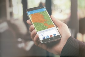
High quality insights are only useful if they rapidly reach the people who can make change. A key part of the EnviNavigator project was to integrate the service into applications used by foresters and forest owners, so that information can be easily accessed.
Through these applications, EnviNavigator automatically alerts sites that need attention. Both foresters and forest owners can have access to the data, enabling greater transparency, agency and understanding of the forest health in both parties.
Sanna Härkönen, the R&D Director of Bitcomp Oy, said: “We do not analyse satellite data and develop artificial intelligence algorithms because it is trendy. We develop services that concretely make forest professionals’ work easier and forest owners’ services better. The EnviNavigator project is not only about satellite data but also about enabling its advantages in field work.”
EnviNavigator began as a forest change detection service in 2019, analysing physical changes in the environment. The Finnish Forest Centre began using Bitcomp’s service for real-time monitoring of illegal thinning and felling.
Further development of the algorithm was possible with support from an ESA Demonstration Project. Some of the variables added include storm and insect damage, and the system is now able to provide better carbon storage estimations as well as predictions of future forest health based on detection of health risk status.
“The EnviNavigator service is a great example of digital transformation arriving in forestry and using satellite Earth observation data to visualise forest management needs and in this way empowering and involving forest owners directly,” said Volker Schumacher, Business Applications Engineer at ESA.
In Finland, the EnviNavigator AI now covers the whole country. It is set to be made available for all Finnish forest owner associations and their customers through the platform LeafPoint, thanks to a contract with the head organisation of forest owner associations (MHYP).
In Germany, EnviNavigator so far covers the whole country for change detection and vitality mapping services, with deeper insights planned. Here, it will be available as part of the Woodsapp.de solution.