Climate change and the degradation of biodiversity call for urgent measures to effectively protect and restore ecosystems, and to build new more sustainable infrastructures. The World Economic Forum Global Risk Report 2024 cites biodiversity loss and ecosystem collapse as one of the top three risks to the global economy, with half of global GDP ($44 trillion) nature-dependent at least to some extent. Addressing this, UK-based company Gentian, supported by the European Space Agency’s Business Applications and Space Solutions (BASS) programme, has developed a pioneering biodiversity monitoring solution that harnesses very high-resolution satellite imagery, including multispectral and radar data, combined with AI analytics.
The Gentian application addresses the global biodiversity crisis and the need for high-quality data to protect and restore natural habitats. This space-enabled approach delivers fast, accurate, and repeatable biodiversity insights at a scale and frequency not possible with traditional survey methods—cutting both costs and time dramatically.
The innovative combination of satellite data with machine learning allows for consistent long-term monitoring. This capability is essential for tracking habitat changes over time - something that it is difficult to achieve with in-situ field surveys.
Using satellite data addresses the challenges with current data gathering methods by giving Gentian the following capabilities:
- Ability to cover remote and inaccessible areas
- Ability to cover large areas in a short time frame
- Repeat coverage for consistent monitoring
- Uniform data quality across all regions
- Year round, timely insights
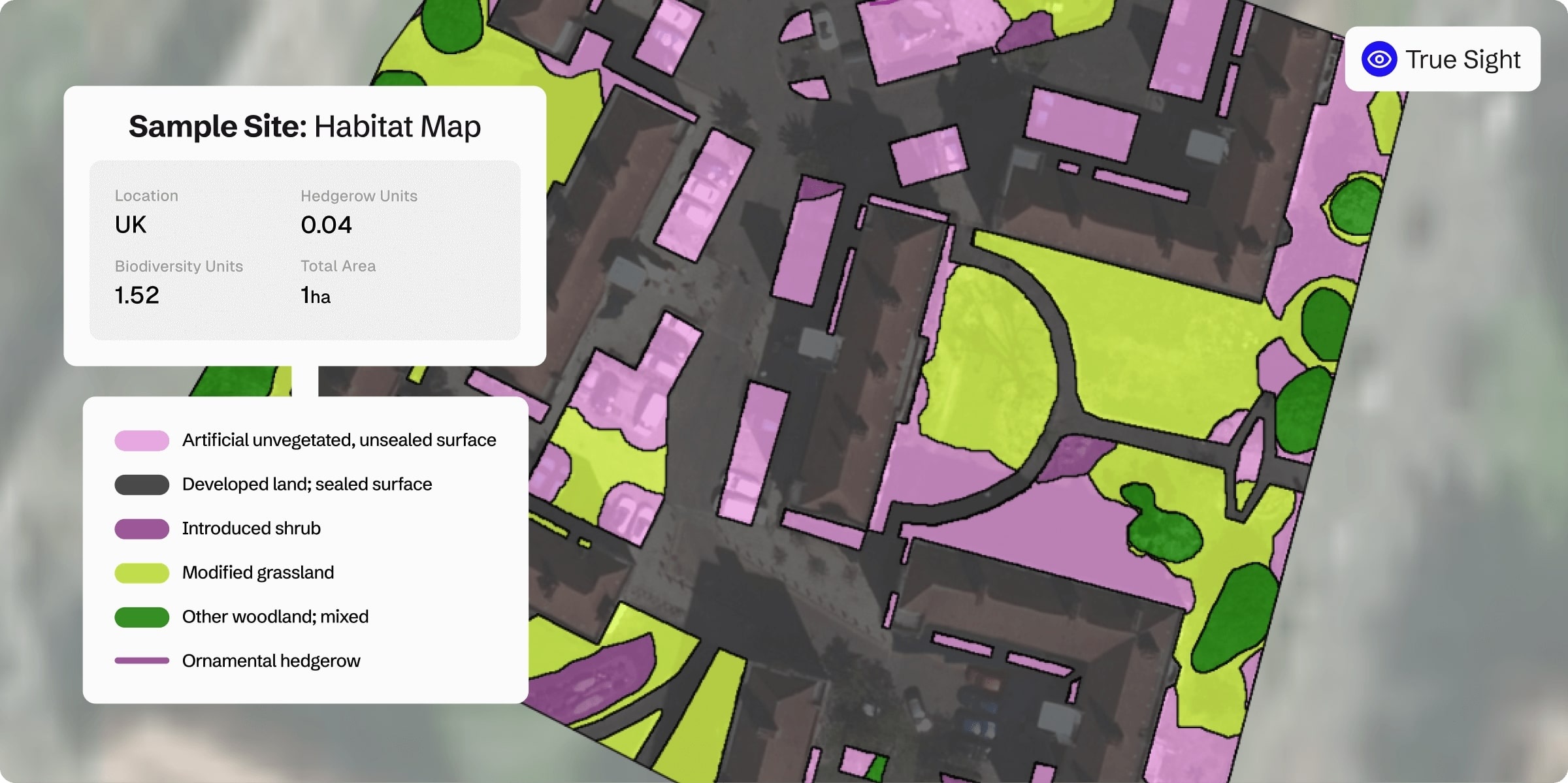
Example of a Gentian True Sight habitat map, showing habitat types and the biodiversity value for a 1-hectare site in the UK.
The early stages of the project confirmed the commercial viability of Gentian’s solutions, with multiple successful engagements and ongoing discussions for further adoption. Key sectors, including local authorities, landowners, redevelopment companies and renewable energy companies, have shown strong interest in using the solution for environmental assessment and sustainability reporting, reinforcing the value of remote ecological insights in regulatory compliance, risk management and conservation initiatives.
Gentian’s vision is to make valuable nature data accessible to all, providing quantified data that is compatible with science-based targets and most reporting frameworks. The easy-to-use software allows customers to select an area of interest and receive back a clear report showing the biodiversity value and features of interest within the area and a buffer zone if applicable. The platform is available as a pay-as-you-go service or as a subscription model.
Within the scope of the ESA Demonstration Pilot, Gentian was able to validate the product-market fit for these data services.
“Space data is the key to unlocking biodiversity monitoring at global scale.” said Karen Day, COO at Gentian. “ESA’s Earth Observation missions, such as the Copernicus Sentinel satellites, provide a vital foundation of consistent, repeatable imagery. When combined with other commercial data sources and Gentian’s AI analysis, it becomes possible to deliver fast, reliable habitat insights anywhere — from a single hectare plot to an entire country — without the limitations or access issues that can make in situ surveys difficult to scale.”
“It is fantastic to be able to support companies such as Gentian deliver ground-breaking solutions to help solve real, urgent challenges relating to climate change,” says ESA BASS Business Applications Officer Guillaume Prigent. “This is what the ESA BASS programme is all about – making space technology accessible to innovative businesses, not only to develop commercially successful new products and services that have a positive impact on the environment, but ultimately to help underpin European prosperity and resilience in the long-run.”
"Gentian is a very unique company, not only because they handle data with high precision (<50 cm resolution), which has been difficult to achieve with conventional remote sensing technology, but also because of their deep expertise in ecology."
Sho Ito, Sustainability Consultant
MS&AD
Keep up-to-date with articles like this by signing up to our bioeconomy newsletter.
Posted to Hero article section
Posted to Hero article section