
ACRI-ST
France
Inria
France

PREDIFAN
May, 8 / 2026
Next-generation geospatial models to support coastal risk insurance and risk mitigation

Coastal risks such as storm surges, erosion and the impacts of rising sea levels are escalating, impacting millions of homes and high-value assets. At the same time, the combination of this potential high impact with unpredictability is leaving some areas uninsurable. With the support of ESA's Business Applications and Space Solutions (BASS), UK-based Ocean Ledger has developed as a solution a next-generation coastal surge model to improve accuracy, transparency, and nuance for insurance risk exposure management.
Digital Elevation Models (DEMs) are essential for understanding and managing coastal risks. Existing models are however often static, may rely on outdated bathymetric or shoreline elevation data or are too coarse to capture localised coastal dynamics, which limits their value for risk assessment and operational decision-making.
Ocean Ledger is addressing the gaps in coastal risk data used in DEMs by integrating multiple sources of satellite Earth observation data, delivering a market-ready geospatial service that provides high-value insights for the insurance and climate resilience sectors, while supporting broader economic and societal protection against climate-driven hazards.
“The specific problem being addressed by Ocean Ledger is the absence of frequently updated, spatially granular and environmentally realistic elevation models which are suitable for integration into risk and insurance models,” explained Ocean Ledger CEO Paige Roepers.
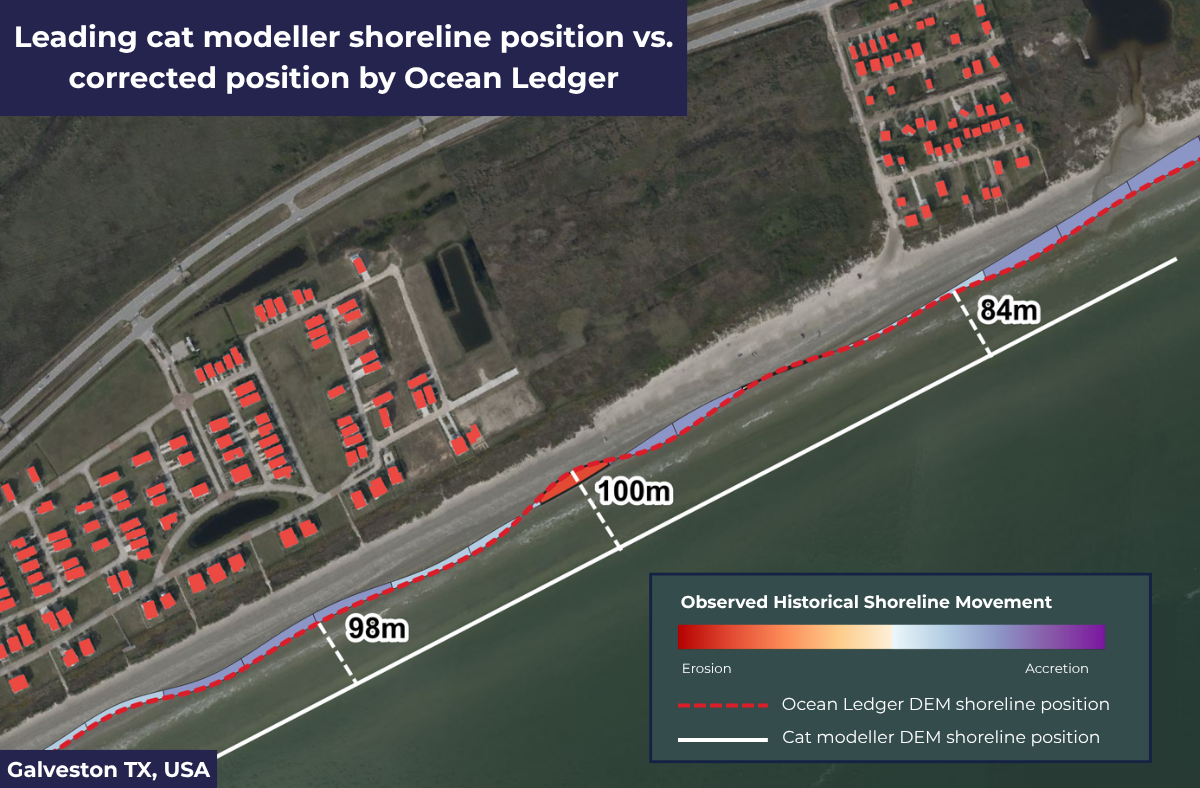
In contrast to existing models, Ocean Ledger takes an observation-driven approach, effectively creating a digital twin of the coastline by using standardised satellite-derived topography workflows for shoreline elevation, shoreline position, vegetation and bathymetry. Their hazard model can be used in comparison to other models and to inform risk reduction strategies for those that own and operate assets.
“Through our project with ESA’s Business Applications and Space Solutions (BASS) team, we have been improving our DEMs, making them more accurate with the latest coastline elevation data and historical trend analysis. This allows us to make better predictions and offer more up-to-date insights than others,” says Ms Roepers. “With that, we can provide more transparency to make confident decisions around risk selection and pricing in highly exposed areas.”
Reflecting on the value of taking part in an ESA BASS programme, Ms Roepers added: “Working with ESA BASS has been a catalyst for us, significantly accelerating both our technological road map and commercial traction. The funding has allowed us to transition from high-level research and development to actionable market entry.”
“Having the ESA brand and funding behind us has been an invaluable asset and has helped us achieve the letters of support we needed to carry out pilots. We are looking forward to hopefully start a Demonstration Project with ESA BASS soon, to continue our journey with ESA and to deliver those pilots that will then take us closer to commercial contracts across Europe and the US.”
ESA BASS Applications and Partnerships Officer Ana Raposo said: “It has been wonderful to support Ocean Ledger and see the opportunities they have been able to secure within the ESA BASS Kick-start framework. I look forward to seeing how their journey continues and they go on to capitalise on the springboard for success they have now built.”
Community reference
Posted to Hero article section
Posted to Hero article section