Astronika
Bartycka 18
00-716 Warszawa
Poland

Bartycka 18
00-716 Warszawa
Poland
aleja Adama Mickiewicza 30
30-059 Kraków
Poland
During the worst months of the COVID-19 pandemic, emergency call centres experienced extremely high rates of urgent medical calls. Coordination of the ambulance response was challenging and made more complex by the changing landscape of medical resources; hospitals were filling up, and temporary emergency facilities were opening.
The First RESPonse (First Rapid Emergency System against Pandemic) project launched in Italy in July 2020, with the aim to improve coordination of the entire process of a medical emergency request: from a patient’s distress call to the point of hospitalisation.
The project brought together two major players in European emergency service software and telecommunications: GINA Software and Beta 80. Forming a new consortium, the companies achieved complete integration of their products and – supported by ESA – incorporated space technology for enhanced geolocation accuracy and communication coverage.
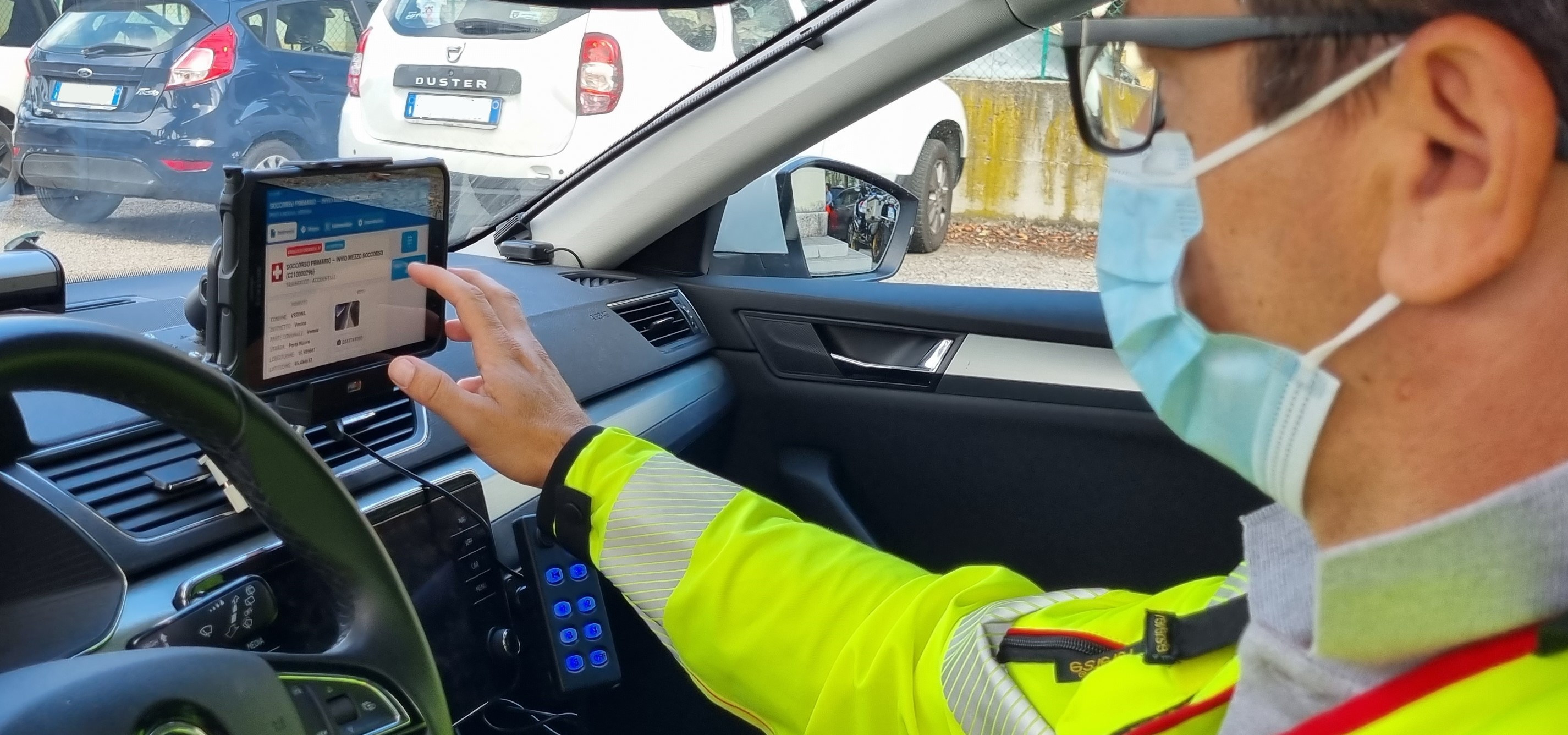
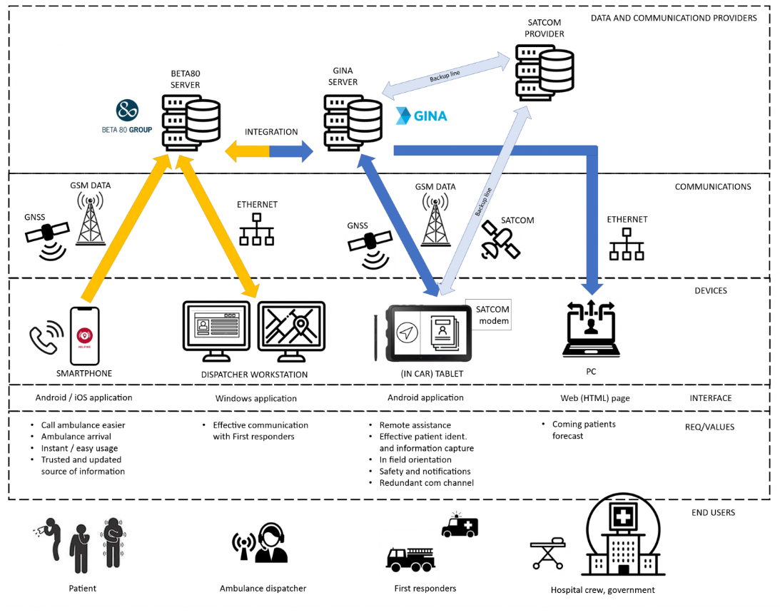
First RESPonse digitally connects each link in the emergency chain of response. It begins with an app on a citizen’s smartphone, through which they can call for help, see when help has been dispatched and when it is due to arrive. Ambulance dispatchers in the call centre have a constant digital connection to their crews via a workstation. They can keep them updated on the scene and patient’s condition, and the status of the nearest hospital facilities. First responders have a tablet through which they receive up-to-date information about the patient, automatic SatNav to their location and can video consult with a doctor from the field. They can also scan the patient’s ID card so that receiving hospitals know who is coming in, as well as seeing when they are expected.
The system was piloted by selected ambulance services in Italy and the Czech Republic and used in almost 9,000 incidents. In this pilot project, First RESPonse accelerated the pre-hospital chain by between 12 and 17%.
Arnaud Runge, Medical Engineer at ESA said: “In a medical emergency every minute counts. Cutting the time it takes an ambulance to reach a critically ill patient, and to get them to hospital, can make a life-saving difference. We’re proud to have enhanced First RESPonse with space technology.”
Following the successful completion of the pilot, First RESPonse is being promoted to emergency services more widely in Italy and the Czech Republic – where GINA and Beta 80 have most of their customers – and beyond.
The system has been gaining interest at the major international events for emergency services: the European Emergency Number Association Conference and INTERSCHUTZ 2022.
Martin Ingr from GINA said: “The products and services that were created during the project are aimed to remain sustainable also after the pandemic is overcome. Our goal is that the problems solved through the First RESPonse project become part of the standard operation procedure. The system can be used again against this or other pandemics, during the response to disasters such as earthquakes, as well as improving daily operations of emergency services.”

The best journey in any vehicle is not always the fastest. It may not be the most direct either. Instead, what you consider the ‘best’ route on any given day will depend on a range of parameters, such as your vehicle, your confidence, your familiarity with the area and how urgently you need to get somewhere. This is especially true for cyclists, who not only have access to routes which are inaccessible to motorised vehicles, but who may also prefer to avoid larger roads, even if they are more direct.
London-based Beeline set out to solve this dilemma by combining satellite Earth observation (EO) and Global Navigation Satellite System (GNSS) location data with feedback from cyclists in a mobile phone app (iOS and Android) as part of an ESA Demonstration Project. The app is linked via Bluetooth to a small device attached to the bike’s handlebars, which provides directions. Beeline has now launched a new enhanced version of its Velo device and app as it expands into new territories.
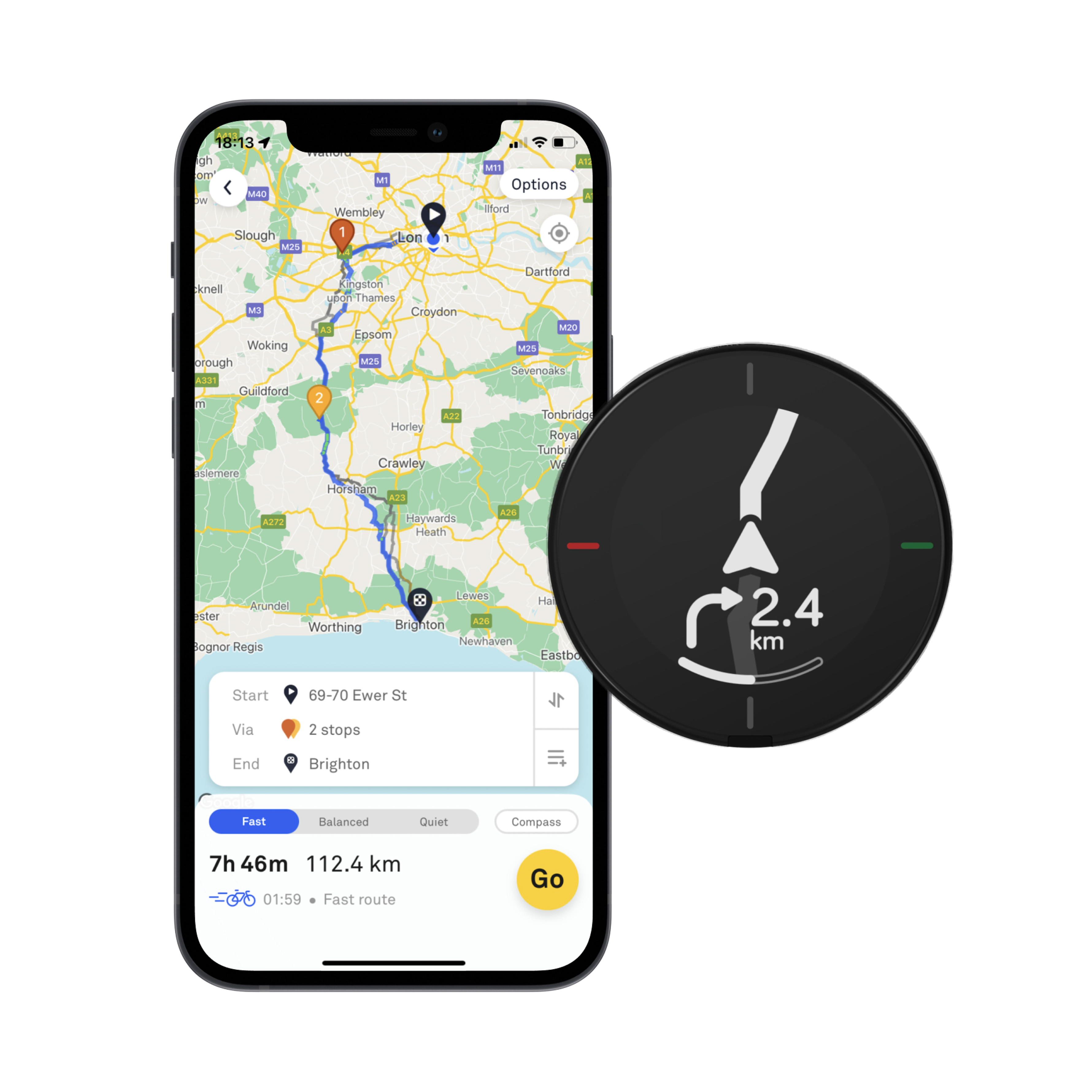
The Velo 2 uses the GNSS data from the user’s phone to ensure that it supplies the correct guidance on when to turn, according to the route chosen by the cyclist from the ones provided on the app at the outset of their journey. Directions are provided via an LCD display on the top of the Velo 2.
Among the EO data sources used for the app are digital elevation models from NASA’s Shuttle Radar Topography Mission (SRTM) which, along with other EO data, are initially used to predict road characteristics. This function is enhanced over time as more and more Velo users travel along each road, as the device also features buttons where users can rate segments of the route they deem to be positive or negative for cycling, based on their individual judgement. This Velo data is then analysed together with artificial intelligence (AI) algorithms to further characterise the quality of the road and improve the overall mapping. This means that every Beeliner around the world plays a part in building better routes.
The Beeline Cycle Routing ESA Demonstration Project started in November 2018 and finished in July 2021. As part of this phase, the team measured journey satisfaction using its app against those proposed by Google and found that Beeline sent users on 67% fewer ‘bad’ roads, with an average journey duration increase of only 6%. Beeline routes were clearly skewed towards cycleways and minor roads.
“The support provided by ESA during the Demonstration Project was vital in order to enable us to develop and test the service, and incorporate the space-derived data, without which our routing system simply wouldn’t work,” said Tom Putnam, Co-Founder of Beeline. “We could have tried to make this work just by using feedback from cyclists. However, we’d need an enormous amount of road rating data to cover every street in all the geographies we aim to cover which would be unattainable. By applying AI to the GNSS based road rating alongside existing Earth observation data we can achieve the coverage we need.”

Oil and gas supplies are dependent on multiple factors, including the stability of the ground wherever oil or gas is being stored or transported. In March 2021, LiveEO started assessment and development of an end-to-end solution for monitoring ground deformation for the entire value chain of the industry, based on interferometric synthetic aperture radar (InSAR) satellite data combined with artificial intelligence (AI). The aim was to help the industry ensure safety across its assets by providing an early warning system that could inform maintenance or safety actions.
Founded in 2017, LiveEO has a background in using Earth observation (EO) data to provide a range of services to operators of large-scale infrastructure, such as railways, electricity grids and pipelines. It combines data analysis with risk analysis to create actionable insights on aspects such as vegetation management, detection of construction activity and ground deformation monitoring — all of which present challenges for reasons that include climate change and environmental factors.
With this Kick-Start activity, co-funded by ESA, LiveEO’s team used its experience in servicing pipeline customers to explore the feasibility of a holistic, end-to-end solution for ground deformation monitoring. The investigation included risk models that quantify the risk to specific assets resulting from ground deformation and how the insights could be delivered to customers and integrated into their processes to create automatic triggers.
The LiveEO team analysed the opportunities through surveys of more than 50 companies and countries, including existing clients in the pipeline industry, as well as researching the broader landscape. Initial data came from Sentinel-1 synthetic aperture radar (SAR) imagery, which will be enriched by higher resolution StripMap and SpotLight SAR imagery from Capella Space or ICEYE satellites to investigate any anomalies that have been detected.
Sven Przywarra, the Co-CEO and co-founder of LiveEO said: “The Kick-Start activity enabled LiveEO to validate a business case in a unique setting, and also created an environment that allowed our business development team to take the right steps from a business idea to product development. The combination of guidance, support and clear goal setting from ESA was greatly appreciated, because it gave us the entrepreneurial freedom necessary for the exploration of new ideas paired with acquiring a depth of knowledge similar to a classic research project."
The requirement for such insights results from an increasing number of oil wells, pipelines, storage facilities and other oil and gas related infrastructure exceeding their original lifespans. This is leading to more complex maintenance for operators and increased risks that impact both the industry itself and the surrounding environment and communities. One of the major sources of risk is ground deformation due to industrial operations or natural seismic activity. Where infrastructure and assets span large areas, these risks can be very difficult to measure and dangerous trends can go undetected.
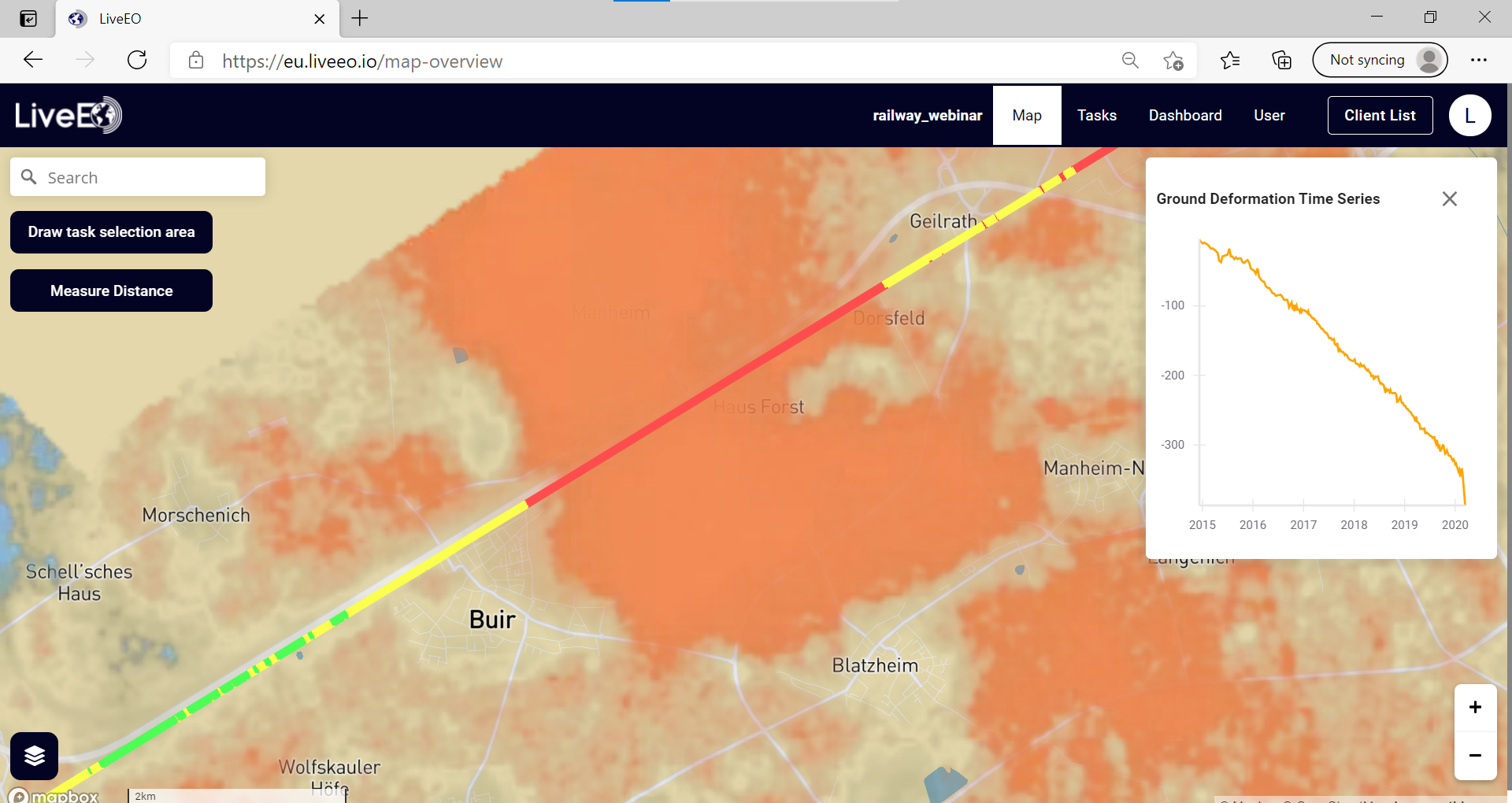
Traditional monitoring methods, such as land surveying or sensors and drones, can only give a partial picture. Satellites enable monitoring of deformation trends across entire countries with weekly update intervals — something that would be prohibitively expensive or even impossible via other means. InSAR data delivers deformation values at individual pixel levels, allowing the identification of trends over long periods of time; this can be supplemented with historical data.
The company is currently developing the AI side of the project, with the aim of completing development by the end of 2022. The plan is then to undertake a demonstration project and have a marketable subscription service ready by the end of the following year.
e-Patient: open 14 July 2022 to 22 September 2022 at 13:00 CEST
Healthcare system transformation: open 22 September 2022 to 03 November 2022 at 13:00 CEST
Healthy cities: open 03 November 2022 to 15 December 2022 at 13:00 CET
The third cohort of companies to receive backing from ASPIRE with ESA has been announced. Selected from a highly competitive shortlist of 11, all five – Geomatys, LiveGreen, Monava, AgreedEarth and CarbonFarm – will now receive funding through ESA’s Initial Support for Innovation (EISI).
EISI is described as a “more agile and responsive way for companies and institutes to access ESA programmes”. Effectively companies are awarded a grant allowing them the freedom to spend the funding as they see fit. Companies do not have to undergo a formal reporting process although an ESA official will loosely oversee the project as it develops. This autonomy allows for a greater degree of innovation.
One current requirement that ASPIRE with ESA stipulates, however, is that all projects comply with the UN’s Sustainable Development Goals (SDGs) Framework, an extensive list of objectives including sustainable cities and communities, reduced inequalities, climate action, quality education and gender equality.
“All five companies selected are committed to achieving these goals,” says Gonzalo Martin de Mercado, Business Development Officer at ESA. “ASPIRE with ESA carefully curated the applications and are pleased to offer all the successful candidates direct access to our technology and business expertise. We are looking forward to working with all of them.”
The first of the five, Geomatys, is a French geospatial intelligence and IT development company. Its analytics technology provides a forecasting and alert system for infectious diseases, especially those prompted by changes in the environment. It aims to bring together industry and governmental health authorities using its decision-making platform so they can work closer together to prepare for when outbreaks occur. The SDGs the project is linked to are good health and wellbeing, and climate action.
LiveGreen is based in Sardinia, Italy. It was founded in 2017 with the intention of becoming a market leader in microalgae production. It produces spirulina algae, the protein of which can be used to create a powdered substitute for meat, soybean, and pea flour. Its Breathing Buildings for Sustainability pitch to ESA aims to reduce the impact of buildings in urban areas. It uses carbon dioxide produced in the building to grow microalgae for various environmental applications. The SDGs addressed are affordable and clean energy, and sustainable cities and communities.
Swedish company Monava specialises in sound and vibration, specifically used in early warning systems. Its pitch suggested using this expertise for monitoring avalanches and landslides in mountainous regions. Sensors collect data and when key information is received local authorities can be notified of the impending threat, closing roads, railways and alerting people at risk. The SDGs covered are decent work and economic growth, and sustainable cities and communities.
AgreedEarth is a UK startup using satellite data to promote sustainable farming practices. The company intends to use its EISI funding to help farmers reduce their reliance on nitrogen fertilisers which release nitrous oxide, a greenhouse gas responsible for global warming. Satellite data identifies areas where levels are high and provides this information to agronomists. Like Monava, the SDGs addressed are decent work and economic growth, and sustainable cities and communities.
The last of the five, France-based CarbonFarm, is committed to decarbonisation. Agriculture represents 20% of greenhouse gas emissions with rice-growing alone accounting for 1.5% of emissions and 10% of all methane produced. Using satellite data, CarbonFarm hopes to cut emissions from rice by half, also reducing the need for manual inspections of crops. Its SDGs target zero hunger, and clean water and sanitation.
“All the companies chosen have clear targets and all tackle the UN’s SDGs,” added Felipe Villalobos, ASPIRE WITH ESA cohort manager. “Congratulations to all five and we look forward to the societal and environmental benefits that all will offer over the coming years.”