ESA title

Portfolio

PROJECT SHOWCASES

22 November 2017

Reducing the risk of bird strikes using satellite images and Ascend’s Normalised Difference Water index software (NDWI)

16 August 2017

British start-up Rezatec has developed a landscape monitoring service based on Earth Observation data

06 June 2017

A new forestry monitoring service, which is currently being used by three regional forestry departments in Poland, combines space and terrestrial data with a web-based interface.

09 May 2017

With the support of ESA, Belgian SME Ovinto has developed a service that offers satellite-based monitoring of rail cars and intermodal tank containers.

20 March 2017

A new satellite-enabled information management system for commercial fishermen, developed the support of ESA, is currently being used by some seventy Irish fishing vessels.

14 February 2017

Managing seasonal navigational hazards, such as winter ice, on Romania's section of the Danube river is the goal of an ongoing ARTES IAP Demonstration Project.

06 December 2016

With the support of ESA's ARTES Applications programme, 21Net has built a system that seemlessly integrates satcoms to improve the user experience of WiFi on high-speed trains.

11 November 2016

The GeoSHM structural health monitoring system, developed with the support of ESA, is now being further deployed in Scotland and China.

03 November 2016

The Basilicata Region in southern Italy has announced the allocation of a nearly one million euros to support an ongoing ARTES Applications project, ONE Class! Open network for Education.

28 July 2016

An integrated rescue management tool being developed with the support of ESA is improving the speed and accuracy of search and rescue missions in the mountains of the Czech Republic.

30 June 2016

With the support of ESA, HydroLogic (NL) is developing an application called the HydroNET Flood and Rain Report generator to map rainfall and flooding quickly and easily. It has been successfully deployed in flood-prone Australia, and other countries are taking interest in the system.

01 April 2016

An enterprising Dutch startup is developing a viable business using Sentinel-1 SAR imagery to monitor oil and gas pipelines from space.

25 January 2016

Thanks to a new portal video encoder device developed with the support of ESA, high definition video can now be cost-effectively streamed from mobile satellite terminals. This breakthrough facilitates the transmission of broadcast-quality video content from regions with limited terrestrial infrastructure.  


15 November 2015

With the support of ESA through the ARTES IAP programme, Vista GmbH has developed a successful business supplying precision agriculture services to farmers. At this year's Agritechnica trade fair in Hannover, the Munich-based company was awarded a gold medal for innovation in recognition of its achievements.

15 September 2015

A recent ARTES IAP demonstration project shows how satellites give the deployment of RPAS a huge boost. The project leader, an enterprising British SME, is capitalising on this experience to develop a viable business in remote surveying services.

24 March 2015

Long-term monitoring using historical Earth Observation data and short-term GNSS positioning is a potent combination for studying the health and well-being of complex structures such as bridges.

24 February 2015

Demonstration and pilot implementation of a satellite-based operations control system for managing teams in alpine rescue missions.

26 January 2015

How satellite services give landowners an easier and cheaper way of calculating the potential economic value of conserving or restoring environmentally important peatlands.

07 November 2014

In an activity supported by ESA, a software package called VECMAP was developed that uses Satellite Navigation and Earth Observation data to populate an online database, allowing researchers to map high-risk areas. 

10 September 2014

With the support of ESA, Irish company Treemetrics has developed an innovative system that uses space and ground assets to map forests and monitor tree-harvesting machinery.

26 August 2014

Thanks to European telecoms satellites, affordable broadband Internet access via satellite is becoming reality. 

23 May 2014

Two recent ARTES-funded feasibility studies looked into ways of understanding and mitigating the risks associated with unstable terrain.

06 May 2014

The incorporation of satellite communication services in railway signalling systems is now one step closer.

11 March 2014

A robust portable device for monitoring vital signs and providing communications for medics developed with the support of ESA offers a lifeline even in the remotest areas on Earth via satcoms.

14 February 2014

ASSIST allows project managers to analyse the positive and negative impacts of their Telemedicine services way before they go live.

12 February 2014

European Defence Agency (EDA) and European Space Agency (ESA), have agreed to pursue their cooperation in the domain of Remotely Piloted Aircrafts.

12 February 2014

The Dutch company Robin Radar has recently taken the FlySafe technology down a new and unexpected path.

BROWSE PROJECTS

Based on user needs and industry skills, the evolution of customized solutions and the establishment of innovative services is accomplished through project activities. Focusing on various thematic areas, relevant information on the project activities is provided below.

Thematic Areas
Space Assets
Filter By Prime Contractor Country
Filter By Subcontractors' Country

SURMON

Status date: 18 June 2015

The SURMON Demonstration Project targets airborne Geophysical Survey (GS) and oil  Pipeline Monitoring (PM) services based on the use of a Remotely Piloted Aircraft System (RPAS). Equipped with suitable sensors and making use of satellite communication and navigation, operation of the RPA beyond line-of-sight is enabled.

SSMART

Status date: 30 November 2011

The SSMART project will provide solutions for monitoring and managing multimodal (road, rail, waterways) transports of dangerous goods. Integrating and using available space technologies (satellite navigation, satellite communications, earth observation) with terrestrial systems SSMART will improve safety, coordination, information exchange, and communication for both routine transport operations as well as for emergency situations.

SEWISS

Status date: 14 January 2016

The SEWISS service has been conceived to support onshore wind developers with the complex, expensive and time consuming process of screening and selecting the most suitable greenfield sites for development, without the need for initial travel to sites of interest. The SEWISS system is conceived to be a one-stop online portal, where developers can access recent, relevant, high resolution EO, and non EO data layers, then within the same portal use these layers of data to conduct automated land cover, rooftop recognition, green field, turbine selection and positioning analysis across their areas of interest.


SAT-AIS DPC

Status date: 18 January 2017

The SAT-AIS Data Processing Centre (DPC) Demonstrator is a development co-funded by EMSA (European Maritime Safety Agency) and ESA. The DPC collects SAT-AIS messages, ancillary information for generating and distributing enhanced data services to the maritime community.

Mercury

Status date: 21 October 2014

Project Mercury aims to establish and prove the commercial viability of a new satellite based communications service that will end the isolation of Mobile Breast Screening Units deployed across the UK as part of the National Health Services (NHS) breast cancer prevention and detection programme.

iTRAQ

Status date: 25 May 2012

iTRAQ is a project to develop a dynamic traffic management system for optimising use of the road network whilst meeting growing demands to sustain high standards of air quality in urban environments.
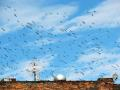
FlySafe

Status date: 18 March 2014

Bird strikes on aircraft pose a real safety threat for both military and civil aviation. Depending on specific circumstances such as the speed of the aircraft, the point of impact, the mass of the bird, the number of birds and the type of aircraft, bird strikes can result in devastating accidents.

FAAPS

Status date: 19 March 2013

Floods affect more people and cause more property damage than many other natural hazards. FAAPS (Fully Automatic Aqua Processing Service) proposes to support emergency management professionals with the provision of flood extent maps even in rain conditions and over large areas.

Dively

Status date: 19 December 2017

Dively is the first mobile application that supports a safe experience for underwater sports fans. Thanks to a powerful combination of environmental data and 3D underwater views, planning your next experience will be a breeze. Designed by divers for divers, Dively presents complex earth observation data and bathymetry in a visual, easy and user-friendly way, with the aim of enhancing your experience while boosting your safety.

CapeOutdoors3D

Status date: 19 December 2017

CapeOutdoors3D prototyped a web-based (and conceptualised a mobile) application for tourists planning outdoor activities in Nature Reserves and National Parks in South Africa. The project linked the space technologies Earth Observation and Satellite Navigation with the aim to provide a 3D virtual reality planning tool for tourists. In addition, Earth Observation based fuel condition maps were developed to support protected area authorities in their fire management activities.

B-LiFE

Status date: 18 December 2017

The ESA IAP-ARTES 20 “Biological Light Fieldable Laboratory for Emergencies” (B-LiFE) Demonstration Project is the follow-on of the B-LiFE Feasibility Study and deals with a new service providing biological analytical capabilities with integrated space assets for emergency response during health crises and epidemics.