

Reducing the risk of bird strikes using satellite images and Ascend’s Normalised Difference Water index software (NDWI)


BROWSE PROJECTS
Based on user needs and industry skills, the evolution of customized solutions and the establishment of innovative services is accomplished through project activities. Focusing on various thematic areas, relevant information on the project activities is provided below.
Infoterra
Status date: 21 May 2012
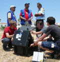
This study was designed to determine the feasibility of the use of space assets such as satellite communications, positioning, and Earth Observation to support the humanitarian mine action community.

Uam®
Status date: 27 July 2017
e2E intends to offer more affordable data communication services into niche markets currently underserved from existing infrastructure or where traditional satellite delivery is too expensive. The core of the service concept builds on two key technologies that have been developed with small airborne IDP networks in mind that incudes RPAS, HAPS and small satellites.

EFFORS-FS
Status date: 25 August 2015
The aim of the present feasibility study is to develop an Enhanced Flood Forecasting System for Critical Infrastructures Protection in medium size Alpine catchments.The service is designed to address infrastructure located either on the river itself (e.g. bridge) or in the flood plan (e.g. a building).
KABALIST
Status date: 13 July 2017
The project is focused on the set up of reliable and cost effective distribution of live video feed of non-mainstream sport events into the Internet. The context and the proposed pilot service is tailored to the Serie C Italian football league. The novelty introduced with this pilot project is the adoption of uplink in Ka-band using inexpensive and semi-permanent installations to the stadiums, supported by a set of features to ensure compliance with the targets in terms of availability, quality, accessibility and costs.
CyMonS
Status date: 22 June 2017
CyMonS offers spatial and high-frequency water quality monitoring of inland surface waters, combined with a 1 to 5 days forecast for cyanobacteria scums. The service integrates Sentinel-2 imagery, hand held monitors (EcoSpot & WISP-3) and fixed position monitors (EcoWatch) to monitor cyanobacteria with a high spatial scale. The algae forecasting model allows water authorities to timely issue warnings and take mitigation measures.
Com4Offshore
Status date: 27 June 2017
The Com4Offshore services enable communication and information exchange between offshore and onshore supporting logistics processes and construction workflow with the aim to significantly reduce the time and costs of the costly offshore construction projects. It offers:
- Satellite based public service supporting the communication needs of the different user groups in offshore wind farm areas.
- Technically and economically optimal solution to the users irrespective of their location by combining wireless, mobile and satellite network technologies.
- Access communications services, sensor devices & software applications for offshore construction activities
Saltwater
Status date: 05 October 2016
Saltwater is a service for aquaculture companies using Earth Observation and hyperspectral in situ instruments for the monitoring of harmful phytoplankton. Monitoring results are provided on a high spatial and temporal resolution. When combined with other environmental data the users can predict the movement of harmful phytoplankton, thereby reducing loss of stock and increasing feeding days.
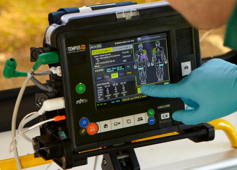
Amazon
Status date: 12 May 2017
The objective of this project is the development and validation of a tele-assistance service, using multiple space assets, for professional clinical users in remote locations using a compact device for vital-sign monitoring and remote diagnosis. It is based on a previous ESA-backed project, which resulted in the deployment of a telemedicine system for commercial aviation applications (TEMPUS)

SELIAT
Status date: 13 April 2015
SELIAT stands for the feasibility study Safe Emergency Landing in Alpine Terrain. It has investigated a service in aviation that shall provide geographic information about suitable landing sites to support off-field landings in alpine areas with difficult terrain. This information will be available to pilots in their cockpit. The information may be required either as part of an operation of a search and rescue mission or in case of a technical failure in the aircraft.
STAR-FISH Feasibility Study
Status date: 11 May 2017
STAR-FISH is a management system that will automatically monitor and record fishing activity and fish discarding, in order to verify compliance with discarding regulations. The STAR-FISH service will consist of:
- A Remote Monitoring System (RMS) (hardware and software) installed on board vessels to monitor, record, identify and transmit fish discard data
- On-shore software which monitors fishing and discarding data from vessels and can provide alerts to fishing regulators
- Interfacing with databases/platforms to support fish sustainability and traceability statistics
STEAM
Status date: 04 May 2017
The objective of this study is to investigate the technical feasibility, financial/non-financial viability and sustainability of a future service aiming at measuring the amounts of sulphur oxides components ejected by vessels travelling inside the Emission Control Areas (ECAs) as defined by the International Maritime Organization (IMO).