

Reducing the risk of bird strikes using satellite images and Ascend’s Normalised Difference Water index software (NDWI)


BROWSE PROJECTS
Based on user needs and industry skills, the evolution of customized solutions and the establishment of innovative services is accomplished through project activities. Focusing on various thematic areas, relevant information on the project activities is provided below.
The Digital Worksite
Status date: 01 August 2025
The Digital Worksite project develops a satellite-enabled solution to improve safety and efficiency for railway maintenance teams by tracking people, vehicles and equipment in real-time during worksites.
GRailMon
Status date: 01 August 2025
The GRailMon project aims to fine-tune and demonstrate an innovative GNSS-based solution for monitoring the 3D position of sections of railway tracks with millimeter precision.
RoadCast
Status date: 01 August 2025
RoadCast provides high-resolution, route-based weather nowcasting to support safer and smarter mobility. Our solution delivers real-time forecasts and hazard alerts for rain, wind, hailstorms and road conditions, enabling proactive risk management and reduced losses for autonomous vehicles resulting safer and expanded operations.

Evento
Status date: 01 August 2025
Experience the future of ticketing with Evento – the secure digital marketplace using geofencing to stop fraud and duplicated tickets. No scams, no copies. Just safe purchases, easy ticket management, and real-time event info right at the venue.
VIRTUE
Status date: 28 July 2025
A system integrating AI, UAVs, and satellite assets to enhance real-time human detection to fundamentally improve Search and Rescue (SAR) missions in the benefit of SAR responders.
SCORE
Status date: 24 July 2025
SCORE is your satellite-powered ally to identify, rate, and manage high-quality carbon projects—smarter, faster, and globally. Unlock nature’s carbon potential and turns satellite insights into climate-smart carbon strategies.
5SEnSES
Status date: 22 July 2025
5SEnSES is a service (SaaS) based on cloud-native platform for the gas and oil extraction sector. It integrates seismic, satellite (SAR), GPS and IoT data in real time, correlating ground-surface movements, seismic activity and pore pressure through an AI engine. The platform delivers faster, cost-effective, environmentally responsible monitoring and predictive simulation, surpassing traditional assessment methods and complying with all regulatory and legislative requirements.
VARESAS
Status date: 21 July 2025
VARESAS is an advanced solution designed to support rescue teams in crisis situations by providing real-time situational awareness. By integrating data from multiple sources and leveraging technologies such as augmented reality (AR), artificial intelligence (AI), and machine learning (ML), it enables teams to coordinate, manage, and execute operations with greater efficiency, precision, and speed.

Verisat.AI
Status date: 17 July 2025
Verisat is a tool that detects AI-generated or manipulated satellite imagery. It helps journalists, analysts, and decision-makers verify visual content using advanced machine learning models trained on real and synthetic satellite data.
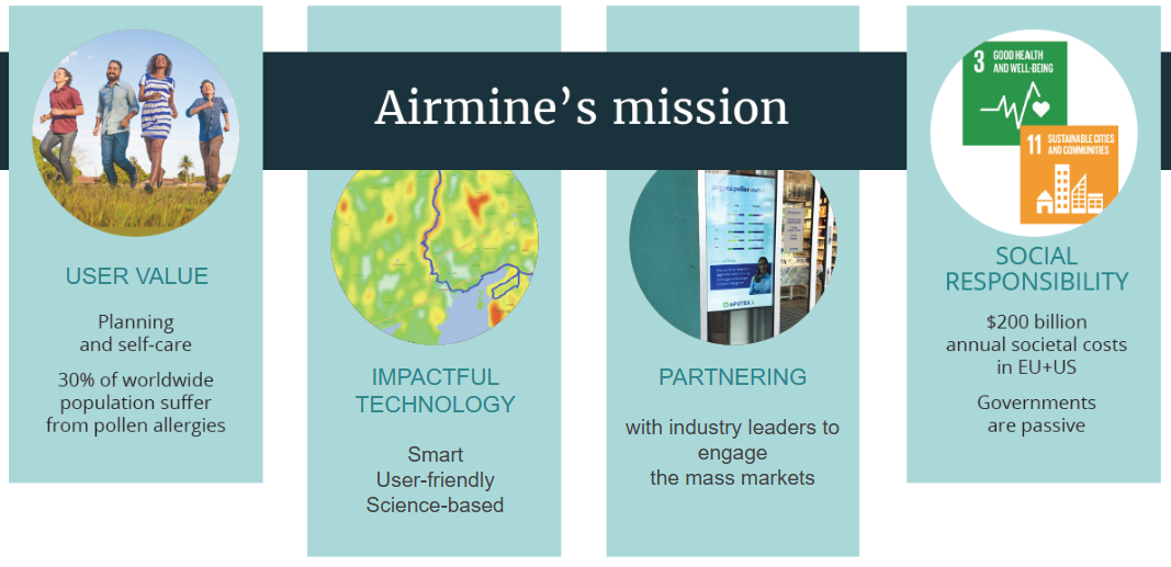
Sustainable Pharma
Status date: 16 July 2025
Pharmaceutical companies are under growing pressure to adopt more sustainable, patient-centric approaches, particularly in response to environmental factors like air quality and climate, which increasingly impact public health.
To explore how the pharma industry can respond to these challenges, Airmine has conducted extensive interviews with key players across the sector and have investigated possible solutions based on their experience in modelling and delivering innovative products to the users.
AgroRisk
Status date: 16 July 2025
AgroRisk is an analytics platform to help financial companies, corporates, and farmers manage climate and environmental risks in agriculture.
ForestBioIndex-NE
Status date: 10 July 2025
Project successfully validated and tested a comprehensive Forest Biodiversity Index for Nordic and Baltic markets using Earth Observation data. The solution provides forest stakeholders with biodiversity analytics, regulatory compliance support, and management recommendations across multiple countries.
GEOFENCE
Status date: 09 July 2025
GEOFENCE aims at conducting a KICKSTART study for the use of Galileo to deliver superior robustness of geopositioning in the context of a geofencing safety strategy for agricultural robots (agbots).
FARMEX
Status date: 09 July 2025
FARMEX is the adapted version of the original Farmstar service, developed and operated in France by Airbus since 2005. As the leading Precision Agriculture service based on EO in France, Farmstar helps farmers in optimizing the nitrogen inputs in their fields, not only to comply with regulations but also to streamline their operating costs. This project aims to adapt Farmstar to multiple European countries.
https://business.esa.int/projects and search results.
Project acronym or abbreviation
Status date: 08 July 2025
Vertify.Earth tracks the interaction between production or conservation activities and nature. Using satellite data and ground insights, it provides detailed assessments of biodiversity, land use, and ecosystem impacts to support nature-positive strategies and align with global ESG frameworks. Applications range from agroecological practices to evaluating industrial impacts on ecosystems and indigenous communities.
RaumZeit
Status date: 07 July 2025
RaumZeit develops advanced risk assessment for supply chain compliance with the EU Deforestation Regulation (EUDR). With the product offering TradeAware, LiveEO offers an End-to-End software solution for traders and operators of complex supply chains, where users can independently upload geolocations, request precision analytics of deforestation risk, and move straight to automated Due Diligence generation, all within the same system.
S4D and dMRV
Status date: 04 July 2025
Seqana delivers a cost-effective Monitoring, Reporting, and Verification (MRV) solution for agrifood companies, carbon project developers, and farming platforms. Using satellite data and machine learning, we map soil carbon levels and reduce the need for physical sampling, which cuts costs without compromising accuracy. Our approach enhances scalability, compliance, and transparency, enabling smarter, data-driven carbon farming.