Reducing the risk of bird strikes using satellite images and Ascend’s Normalised Difference Water index software (NDWI)
BROWSE PROJECTS
Based on user needs and industry skills, the evolution of customized solutions and the establishment of innovative services is accomplished through project activities. Focusing on various thematic areas, relevant information on the project activities is provided below.
SaMoLoop
Status date: 26 March 2020
A service platform and data services solution, fully focusing on supply chain optimization through integrated software services. The ultimate aim of this solution is to optimize logistics and increase efficiency in the complete rail and intermodal freight supply chain, for multiple stakeholders at the same time.
ERP
Status date: 23 March 2020
The ERP kick starts aims at delivering solution blueprints for forecasting
- the utilization of public fast-charging sites for Electric Vehicles (EV) and cover methods for the provision of EV navigation to the next suitable charging site
- on suitable geographical areas for new fast-charging infrastructure
- on EV public fast-charging energy demand (incl. peaks/lows)
SkyLiberty CCN#1
Status date: 20 March 2020
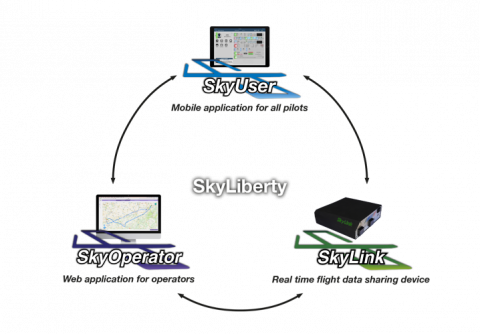
Through the SkyLiberty project, ESNAH has created a service associated to a set of different products to support pilots and other aviation stakeholders in the performance of safe and effective flights.
Originally designed for aviation, the SkyLiberty service has proven to be useful in several other domains (e.g. boats or trucks tracking).
The service is composed of several modules named SkyUser (mobile application and web for pilots), SkyOperator (web application for operators, i.e. persons or entities owning and renting one or more aircrafts to pilots) and SkyLink (tracking device and satellite modem), which have different functionalities tailored to the needs of various stakeholders.
TreeTops
Status date: 15 November 2019
Treetops use high-resolution images from Satellites, UAVs and Airplanes, to facilitate the use of remote sensing in the forest industry. This online tool analyse forest Canopy Cover and Single Tree Detection. Compared to traditional measurement methods, this new solution enables more reliable analysis for forest monitoring and estimation of the forest assets.
ARGOS > INSIDE
Status date: 12 March 2020
In parallel to the CLS initiative to design a satellite constellation dedicated to Space IoT called Kinéis, this study aimed to analyse the market opportunity of a recently developed hybrid Argos chipset with terrestrial communication capabilities to fill coverage gaps . A largely increased satellite data collection capacity and low cost and small size terminals will permit to significantly multiply the number of devices. Three application areas have been targeted in the feasibility study: container shipping, artisanal fishing, equipment operation control especially for humanitarian aids.
EO Claim Ledger
Status date: 04 March 2020
The insurance industry is facing several challenges today: an increasing number of natural disasters and related losses strain their budgets. The EO-Claim Ledger aims to support the insurance industry by providing a fully automated claim management system making use of Earth observation imagery. Blockchain technology allows the provision of a secured system. It reduces administrative costs and prevents fraud.
MARVELOWS
Status date: 04 March 2020
The project objective is to identify and specify new services using VDES (VHF Data Exchange System), so leveraging robust ship-to-ship, ship-to-shore and shore-to-ship communications that this technology makes available. Starting from e-navigation Maritime Service Portfolio (MSP) as defined by IMO e-navigation strategic implementation plan, two services have been identified that mostly match the Contractor business opportunities: dematerialisation and towage.
RESUCI
Status date: 04 March 2020
RESUCI is an undergoing project developed to prove the technical and commercial viability of using spate assets and technology in support of resilient and sustainable right of way corridors for powerlines and pipelines, while simultaneous contributing to mitigate the infrastructure related negative impacts to the surrounding environment.
GroWise
Status date: 27 February 2020
GroWise will give credit providers through the use of growth models for a variety of common African crops an accurate view of the crops in the ground. It will also allow them to deliver agronomic advice, via a new app, to farmers – something which is currently lacking with small/subsistence farmers.
C-HCN
Status date: 20 February 2020
SatADSL project with the objective to commercially offer a highly competitive High Capacity Networking (HCN) service with enhanced functionalities, latency and monitoring capabilities. The value proposition is based on the use of the SatADSL multi-satellites, multi-technologies, multi-frequencies Cloud-based Service Delivery Platform or C-SDP
Fully Automating Data Pipeline
Status date: 11 February 2020
In 2010, the United Nations explicitly designated that "safe, clean, accessible and affordable drinking water” is not only a necessity, but also a fundamental human right. However, we live in an imperfect world, in which man-made activities and natural disasters create conditions that limit our access to water and expose us to dangerous water events. Organisations around the world have recognised this challenge and shown their commitment to creating, as the World Bank terms it, “a water-secure world for all.”
IMGeospatial is honoured to be part of this movement and has partnered with three clients to address the biggest water-related threats to our livelihood: flooding, water scarcity and water quality. We provide business intelligence that enables them to proactively manage their water systems, build resilience in their communities and ultimately minimise risk and impact. We do so by automating the data pipeline, reducing the time and cost of turning earth-observed data into actionable insights.
SkyLiberty
Status date: 07 February 2020
SkyLiberty is a new service based on a software product, which aims to improve the preparation and the performance of flight navigations. It offers a full set of new concepts and services for student pilots, beginner and advanced pilots, aircraft operators, airline companies and passengers
DASF
Status date: 06 February 2020
Spacenus is a Germany-based Artificial Intelligence (AI) company that develops applications for Agriculture. The key competence of Spacenus is speed, practicality and a creative culture for problem solving. We offer AI solutions that incorporate mobile phone cameras and satellite imagery to digitize agriculture as and provide precise farming information. Our goal is to facilitate enhancing agricultural productivity while protecting the environment.
EMC
Status date: 04 February 2020
The EDU-MAT COPERNICUS is related to the use of VR / AR applications in Education. The proposed IT solution aims to create an educational platform with mathematical tasks using visualization of satellite technology in augmented reality. It can be innovative solution allowing students to get acquainted with mathematical knowledge in an interesting way.
Sceye Services Enabled by HAPS Complemented by Satellite
Status date: 31 January 2020
Sceye investigates the feasibility of using High Altitude Pseudo Satellites (HAPS) for increasing awareness in maritime areas through observation and communications relay.
CRESS
Status date: 28 January 2020
Bennamann’s end-to-end fugitive biomethane capture, processing, storage and distribution service gives customers the ability to generate revenue from waste, while facilitating local supply of a zero-carbon energy.
Poworganic
Status date: 28 January 2020
Poworganic is developing a circular micro-credit model powered by satellite imagery, tackling the energy, sanitation and health crisis in developing countries and further.
OneWave
Status date: 28 January 2020
OneWave, is a complement to the Tsunami Early Warning Systems (TEWS), a system able to detect and monitor the front wave of a Tsunami created from a major geological event, earthquake, landslide or explosive volcano by using accurate satellite radar measurements and precise position of the spacecraft of Copernicus Program.
IntVAR
Status date: 28 January 2020
The proposed mobile application will be a platform supporting users interested in active spending time by the water. The integration of GNSS and VR/AR technologies combined with satellite imageries will offer new opportunities to improve travel safety and to help avoid dangerous navigation obstacles. The application will also enable communication between active users and participation in virtual regattas.
Galileorama
Status date: 27 January 2020
Galileorama is a VR platform to experience touristic and retail venues both at home and on-site. It allows the venue operators to easily create and provide visitors with VR 360° panorama media by building upon a common smartphone app (+ virtual reality glasses like cardboard) and a web-based backend.
IWBSF
Status date: 27 January 2020
The aim of this feasibility study is the development of an end-to-end service that aims at providing access to value-added information for forestry users. The idea of the IWBSF is to promote the efficient and widespread use of EO and GNSS elements through published services including analyses outputs from forestry case studies, information concerning distribution, inventory uploading, resource management and archival functions.
TIKKA Service
Status date: 27 January 2020
The TIKKA's service is dedicated to support forest users during their operational task inherent to the development of timber logging plans. The service benefits from the integration of LIDAR, SAR and GNSS technologies. The project output (the maps, analysis and reports) will be published and available for all the authorized person via the web geoportal.
S4CI – Support for Critical Infrastructure
Status date: 13 January 2020
A monitoring service that provides Critical National Infrastructure (CNI) asset owners and operators with resilience against problems associated with structural health through the use of Earth Observation data and in-situ devices.


