Reducing the risk of bird strikes using satellite images and Ascend’s Normalised Difference Water index software (NDWI)
BROWSE PROJECTS
Based on user needs and industry skills, the evolution of customized solutions and the establishment of innovative services is accomplished through project activities. Focusing on various thematic areas, relevant information on the project activities is provided below.
Big data for migration study
Status date: 13 September 2019
“Big Data” refers to new computational capabilities, that warehouse huge set of data, technologies and analytics in order to extract added value from “bulky information” in a reasonable amount of time. The increasing possibilities offered by satellite technologies integrated with collateral data can support the complexity of the migration flow monitoring
AutoNautUSV-CommsHub
Status date: 12 September 2019
An unmanned surface vessel to upload data from remote sea-bed assets by underwater acoustic communications. The wave and solar energy powered AutoNaut USV shall remain at sea for many weeks “harvesting” valuable data. For oil and gas, defence and marine science customers it shall significantly reduce safety exposure in the offshore environment and remove the need for costly conventional vessels.
RSFPS Service
Status date: 25 July 2018
The extension of the TIKKA project on the REMOTE SENSING FIRE PROTECTION SYSTEM is results of the positive evaluation of the TIKKA project by the forest users. The new Service will be based on the TIKKA project conception that has been evaluated and implemented during the demonstration phase for the Forest Users. The service will be implemented and provided to the brand-new market which are the National Parks in Poland. The beneficiary of the RSFPS during the demonstration phase of the service will be the Kampinoski National Park, which is the second biggest National Park in Poland (385 km2) and in 2000 year has been listed on UNESCO List.
Services Enabled by HAPS (Unisphere)
Status date: 02 September 2019
Within the context of satellites, terrestrial infrastructure and Remotely Piloted Aircraft Systems (RPAS), HAPS are a new platform offering unique advantages, but also complement existing services. Three major HAPS applications have been analyzed within this feasibility study. The concept of “HAPS as a Service” (HaaS) has been introduced and its unique requirements to highly automated flight management were detailed. A follow-up demonstration project with the focus on flight management has emerged from this feasibility study.
SatCBRN
Status date: 12 July 2019
SatCBRN explores the use of satellite services for surveillance and hazard management of incidents involving release of chemical, biological, radiological or nuclear threat agents.
COLDSUN
Status date: 21 August 2019
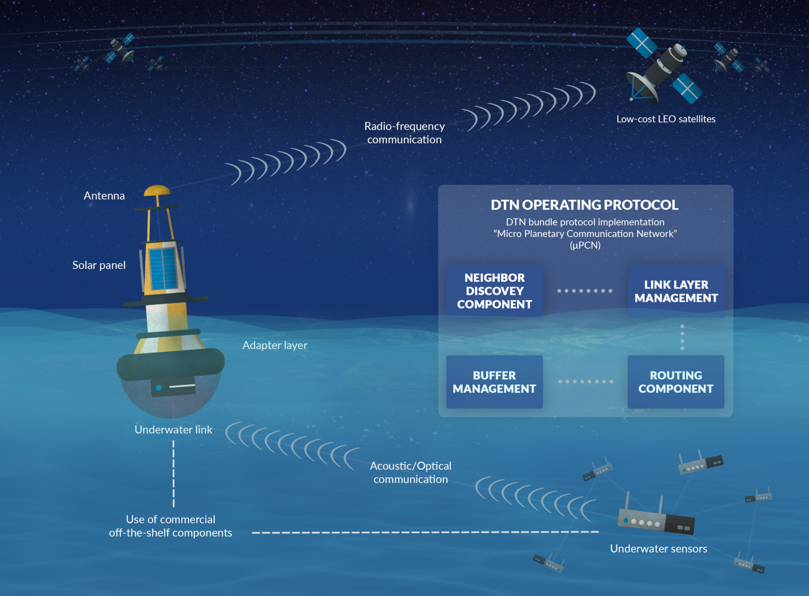
The project has explored a communication service that allows to transmit data between underwater networks and the internet via satellite networks. The overall system renders possible low-cost data transfer using a data relay buoy equipped with interfaces for underwater as well as satellite communication. This offers a cheap and flexible communication solution for companies operating in a maritime environment.
GoWalk
Status date: 12 August 2019
Walk2Health is a smartphone app that encourages older people to take regular exercise. The key problem is that many elderly people lack sufficient motivation to take regular exercise, which leads to health declines. The study investigated the potential of a new smartphone app that provides motivation to older people with reminder messages, charts, and daily targets.
BIGMIG
Status date: 02 August 2019
The study aims at identifying possible applications of space data (imagery, navigation data, satellite communications etc.) and other (“big”) data sources to help and improve the mitigation, readiness and response to the human migration phenomena, and to assess their technical and economic viability.
SAFEDEM
Status date: 01 August 2019
Demining has been relying on traditional techniques in order to perform the critical task of Land release. Space assets, EO products above all, provide a practical and effective support in many phases of the demining activities, helping in surveying the mine affected areas in a more detailed and less expensive way.
Space4Microgrids – India
Status date: 03 January 2019
Space4Microgrids – India
The Space4Microgrids – India project focuses on supporting the implementation and operations of microgrids in India. The overall aim is to determine the feasibility of viable and sustainable operational satellite based services that can subsequently be developed and demonstrated. These services will aim at resolving various challenges related to deployment of sustainable microgrids for remote, isolated and emerging areas in India. Our services will assist in planning, design, operational and maintenance stages.
AIR-Portal
Status date: 20 December 2018
AIR-Portal provides extremely local (100m resolution) air quality monitoring and forecasting, delivering actionable insight for citizens, governments and industry.
The delivered historical, real-time and expected air quality data is based on a unique down scaling algorithm which integrates satellite data, local sensing, land use data, meteorological models, and dispersion models.
DW-TRAC
Status date: 09 July 2019
DW-TRAC (Dangerous Waste Tracking & Tracing) lays the foundation for the implementation of a sustainable service for real-time tracking and tracing of dangerous/hazardous waste in Europe, providing a better service and transparency for customers, carriers and authorities.


