Reducing the risk of bird strikes using satellite images and Ascend’s Normalised Difference Water index software (NDWI)
BROWSE PROJECTS
Based on user needs and industry skills, the evolution of customized solutions and the establishment of innovative services is accomplished through project activities. Focusing on various thematic areas, relevant information on the project activities is provided below.
SAR crop index
Status date: 11 December 2017
This demonstration project is a progression of a number of feasibility studies conducted by AgSpace Agriculture and The Satellite Applications Catapult into the application of Synthetic Aperture Radar (SAR) data for agriculture. The project demonstrates the new crop growth index on 20 UK farms throughout the 2016 and 2017 growing seasons.
MAPP-DEMO
Status date: 11 December 2017
Following a pirates' attack, onboard communication equipments are destroyed: the vessel’s track is lost, the research area grows as time passes, making it harder to deploy rescue assets efficiently.
The challenge is to answer to the question: “Where is my ship?”
The ‘Keep in sight’ service combines a hidden tracker installed onboard and EO acquisitions to provide this critical information.
URGED
Status date: 21 November 2017
URGED addresses an increasing global requirement for the provision of better predictive decision support tools for urban infrastructure managers to enable cities to become more resilient to environmental threats. Through the evolution of Rezatec’s geospatial data analytics and the incorporation of new satellite data sources, e.g. Sentinel 1 and 2, these tools will be accessed through the URGED online platform.
DART
Status date: 09 November 2017
The DART service aims to offer affordable medium distance transportation capabilities to Polish professionals as primary target market. DART will be based on the use of light aircraft located all over the country, by exploiting GNSS-based approach procedures and remote AFIS services. It ambitions to be much cheaper and flexible than current air-taxi like services.
MarIA
Status date: 15 September 2017
This project has developed a cloud-based system to support more efficient management of sustainability standards in commercial fishing and processing operations. The system developed allows for the inputting of information manually into smartphones/tablets and the capture of information from sensors on-board fishing vessels (including GPS position), whilst at sea, which is sent via satellites to a central database. This database is viewable by prospective customers before the catch is landed.
InsureApp Service
Status date: 01 April 2014
This feasibility study carries out an analysis of the most critical elements with respect to technical feasibility and viability (economic as well as non-economic) of a web application aimed at improving the efficiency of the management of insurance claims with a focus on weather-related hazards
SATLAS
Status date: 05 September 2017
SATLAS is an Idea Incubator, developed for and offered to innovators who want to “Start, Integrate and Test” their SatCom related concepts in an easy, light and quick way, taking benefit from the support, mentoring, services and tools made available from the SATLAS consortium (SES Techcom, SatADSL, Newtec).
SatApps
Status date: 19 September 2017
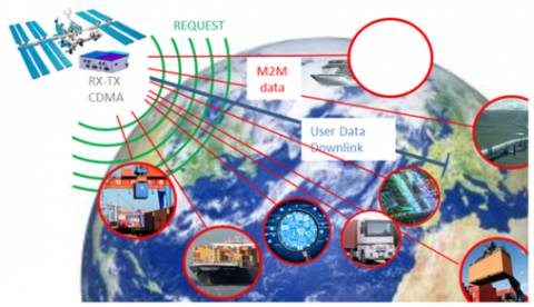
Internet of Things/IoT – M2M – industry 4.0 – these headlines are representing large user groups which have an urgent need of a globally available, low-cost, secure data service, dedicated to very small data volumes per sensor and for use also in remote areas. The objective of the study is to perform an in depth requirements analysis on 2 focus pilot user groups: railway transportation and container/waste management.
SUMO
Status date: 05 September 2017
SUMO is a service to assist in the planning and monitoring of marine operations for offshore wind farms. The service integrates diverse information to allow the monitoring and forecasting of metoceanic conditions and track the locations of vessels and personnel involved.
This improves the management and coordination of the construction, operations and maintenance activities and leads to increased efficiency and safety.
SatSoHoAfrica
Status date: 20 May 2016
SatSoHoAfrica is allowing the provision of competitive broadband internet services to Small-office-Home-office (SoHo) users in Sub-Saharan Africa.
Intelligent sensor and satellite network (ISSN)
Status date: 02 December 2016
The project is a feasibility study in order to establish whether there are sufficient market opportunities, and the technological maturity for developing a flexible and reliable intelligent sensor network where satellites are among the nodes in the network (ISSN). ISSN has a number of potential application areas in connection with Offshore Oil & Gas exploration and production, environmental surveillance in general, safety, search and rescue, transportation etc.
GridWatch FS
Status date: 22 March 2016
The solution intends to provide owners of High Voltage power infrastructures with useful information for supporting the management of both procedures for inspection and maintenance, and dispatching of electrical energy.
Improving the Efficiency of Loss Adjustment and Claims Management in the Insurance Industry
Status date: 13 July 2016
The study analyses the feasibility and viability potential of an earth-observation based service for supporting the claims management process in the forest insurance industry. A main aspect is loss adjustment after large-scale disasters with a focus on storm events and forest fires.
Infoterra
Status date: 21 May 2012
This study was designed to determine the feasibility of the use of space assets such as satellite communications, positioning, and Earth Observation to support the humanitarian mine action community.
Uam®
Status date: 27 July 2017
e2E intends to offer more affordable data communication services into niche markets currently underserved from existing infrastructure or where traditional satellite delivery is too expensive. The core of the service concept builds on two key technologies that have been developed with small airborne IDP networks in mind that incudes RPAS, HAPS and small satellites.


