


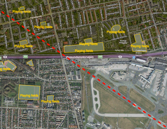
Reducing the risk of bird strikes using satellite images and Ascend’s Normalised Difference Water index software (NDWI)









BROWSE PROJECTS
Based on user needs and industry skills, the evolution of customized solutions and the establishment of innovative services is accomplished through project activities. Focusing on various thematic areas, relevant information on the project activities is provided below.

EuroPORT
Status date: 11 June 2012
The objectives of this feasibility study are to assess the technical feasibility and commercial viability of an integrated solution and associated services which support the optimization of freight transport through ports (e.g. routing and scheduling), based on a better understanding of users and stakeholders needs and transport conditions, and better information exchange.

Invisible Worlds
Status date: 09 May 2019
Rezatec and the Eden Project will explore how geospatial data analytics could benefit individual growers or forest owners with small areas under management, by providing commercially valuable and actionable decision support tools accessed via a self-service, digital platform. In addition, these analytics could be provided as an operational service to other creative visual installations at museums and institutions around the world.
ARCT.esa
Status date: 12 April 2019
The ARCTTM stakeholder mapping tool offers visualization of “Project Health” in the cross-roads between society, environment, business and policy. The unique de-risking tool combines climate change risks with other factors and makes them relevant, simple and visual for owner and decision makers of any infrastructure project.
ARCT has also found a fun and engaging way to score and report on the UN Sustainability Goal Climate Action goal #13. www.arct.tools.

Greenhouse Early Warning Service
Status date: 09 April 2019
Greenhouse owners are in a very competitive market, in which unexpected costs due to damage and decay of the greenhouse assets can cause severe problems. This feasibility study aims to provide insights into how an early warning service using space data can help greenhouse owners to prevent or mitigate non-insurable risks threatening their business.

NG Aviation – Smart Airports
Status date: 28 March 2019
Proposed system serves as a platform for Airside area management based on ICAO and EUROCONTROL legislative as a support for satellite navigation.
AIME Aeronautical Information Management Environment software platform enables to create and share digital aeronautical data including the temporal warning messages (Digital NOTAM) in AIXM 5.1 format.

Ground Instability Risk Profiling (GIRP) now branded as Hi_Ground
Status date: 22 February 2019
Hi_Ground delivers new subsidence risk profiling tools, based on our unique Core Subsidence Hazard Score, for every property and postcode in the UK.

LiveLand
Status date: 20 February 2018
Transport operators across the UK face significant challenges in monitoring and detecting landslides and subsidence across their networks. LiveLand supports asset owners and operators to assess and monitor high-risk areas of their transport network providing improved geological hazard information at regional, network and local levels using integrated data from Earth observation satellites and GNSS.
ConsTrack
Status date: 12 December 2018
ConsTrack serves as a comprehensive construction site information service to the economic and financial sector, through an integrative satellite observation and satellite navigation solution and dedicated IT system.

PRIIMA
Status date: 08 February 2019
PRIIMA serves the need for high-resolution sea-ice forecasts in the Arctic and Antarctic maritime sector. It converts static satellite images into real-time information and even into animations showing the future drift of sea-ice over the next hours and days, while the resolution of the images is being conserved.
NARWHALS
Status date: 05 February 2019
NARWHALS objective is to realise a feasibility study of a service capable to provide high accuracy positioning by monitoring and mitigating the ionospheric impact on GNSS navigation in the Arctic environment. Istituto Superiore Mario Boella (ISMB) and SpacEarth Technology (SET/INGV) propose a possible solution by combining their expertise in low power hardware and managing ionospheric data.

Watch Out!
Status date: 19 December 2018
While wearable tracker gadgets become mainstream, they fail to provide a solution for elderly fall prevention. This new algorithm from Gait Up empowers existing wearables with smart fusion of GNSS and IMU for simple and accurate activity metrics related to elderly falls, like gait speed. The algorithm is implemented in a smartwatch application, satisfying requests from national healthcare institutions.

SENSA
Status date: 05 March 2018
The SENSA project aims at a collaborative platform supporting âsustainable & responsible tourismâ in protected remote areas, such as natural parks, natural reserves and historical sites.