Reducing the risk of bird strikes using satellite images and Ascend’s Normalised Difference Water index software (NDWI)
BROWSE PROJECTS
Based on user needs and industry skills, the evolution of customized solutions and the establishment of innovative services is accomplished through project activities. Focusing on various thematic areas, relevant information on the project activities is provided below.
DHDE
Status date: 05 April 2023
This Business Applications Feasibility Study aims at assessing the technical feasibility and economic viability of space-based services and solutions in the area of digital health, for instance storing and managing health data on people’s existing computers or mobile phones. supporting health infrastructure in developing economies, with focus in Africa and India.
EM
Status date: 04 April 2023
This project followed a successful Feasibility Study in improving the GEOSATIS EM system/service, based on a next-generation GNSS bracelet, satellite communication/imagery; to enhance the current electronic monitoring system to a level where Geosatis has an edge over its competitors in terms of; communication, proximity, detail, signal broadcasting, bandwidth, and device use in a larger geographical area with limited. communication signals.
.
RANGLO
Status date: 04 April 2023
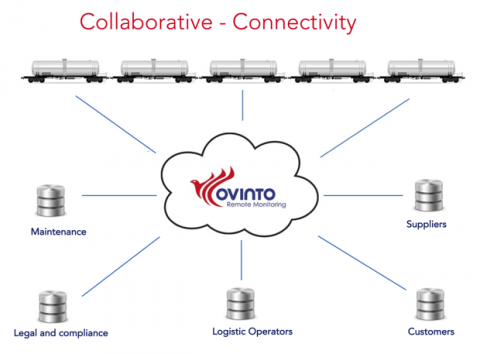
Data integration and predictive analytics service for rail freight in the UK. The Ovinto unique, complementary software platform will help and feed the existing software infrastructure for different users and customers, connecting any relevant internal & external data source to make software modules/silos extremely flexible through collaboration, data exchange and integration.
https://business.esa.int/projects and search results.
SP4GO
Status date: 14 February 2020
SP4GO feasibility study addresses the needs of Distribution System Operators (DSO) and Transmission System Operators (TSO) using innovative solutions.
Demand/Response and e-Mobility needs will be addressed in the context of Smart-grid area, while for the infrastructure operation and maintenance (O&M) the services considered are vegetation monitoring, electric consumption estimation, impact of weather events such as lightning on energy infrastructure, and satellite backup platforms for data exchange and communication.
FOCUS
Status date: 03 April 2023
Project FOCUS seeks to prove the viability of funding the application of a new regenerative farming standard in African smallholder coffee farming through the voluntary carbon markets. The sequestration of atmospheric carbon will generate a new source of income from carbon credits, remotely monitored and verified through the application of satellite imagery and advanced data analytics.
OWASIS WDS
Status date: 23 July 2023
The service provides forecasts of essential water availability and water demand information for water managers. It contributes in creating an essential window of opportunity for end users to timely anticipate, take the right measures and minimise the impact of future events, either droughts or floods.
SEIA
Status date: 27 March 2023
With ESA’s support, DryGro has launched a pilot high-protein crop system in Kenya. By applying earth observation and terrestrial data to the growth system, DryGro’s technology mitigates many of the factors which are currently limiting agricultural productivity. We have partnered with RHEATECH, Hyper Collective, and BuildX to delivery this breakthrough in sustainable agriculture.
3E Solar Data Services
Status date: 27 March 2023
3E Project Development solution provides accurate and bankable satellite-based solar irradiation data for solar power modelling: 3E Solar Irradiation Data. It is your go-to application to assess the long-term yield of future solar assets, improve the return on investment and evaluate operational plant performance.
FlexCurb CurbX
Status date: 27 March 2023
FlexCurb CurbX evaluates the technical and commercial feasibility of an app for cities to digitize curb assets and regulations more easily in cities. By using augmented reality and postprocessing with Earth Observation the app enables highly accurate and standardized curb data generation.
GreenUP
Status date: 27 March 2023
One of our cities' challenges is to design integrated urban environments that balance between growth ambitions, an increasing population and climate emergency, and at the same time introducing new standards for green growth, biodiversity, inclusion and quality of life. The GreenUP project aims to shed light on how satellite technology can be transformed into flexible and user-relevant tools to support local authorities and other stakeholders involved in the development of sustainable urban environments.
oneTcall
Status date: 20 March 2023
No GSM coverage? You are on a plane or ship and you need to receive an important call or to make an important call? No problem: with oneTcall you can continue to use your mobile phone and your telephone number without changing your user experience and without any limitation.
Thanks to Satellite you can have IP coverage everywhere in the World and also in Mobility. With OneTCall + IP via Satellite you can have also your Mobile Phone working and keep using your telephone number.
Easy for the customer. No additional infrastructure required for the Operator.
OneTCall is perfect to provide seamless voice coverage also on board of Airplanes and Ships.
OneTcall is a patented service.
CertiPro
Status date: 28 February 2023
In this truly European project, an innovative railway track worker protection system will be evaluated for its reliability and its ability to enhance the safety of railway track workers. The goal is to demonstrate the safety capabilities of the track worker protection system in a real environment, integrated into the challenging infrastructure of a railway operator in Italy.
DOCS-2
Status date: 15 March 2023
Using civil aircraft to create constellations for providing high spatial & temporal Earth observation data and telecommunication services; a most ecological constellation re-using the most reliable platform.


