

Reducing the risk of bird strikes using satellite images and Ascend’s Normalised Difference Water index software (NDWI)


BROWSE PROJECTS
Based on user needs and industry skills, the evolution of customized solutions and the establishment of innovative services is accomplished through project activities. Focusing on various thematic areas, relevant information on the project activities is provided below.

CEROC
Status date: 07 April 2026
Evaluation of operational feasibility and value of supervising multiple autonomous electric ferries from a centralized Remote Operation Centre.

SOCBIO-MAP
Status date: 07 April 2026
SOCBIO-MAP delivers scientifically rigorous, satellite-enhanced mapping of soil organic carbon stocks and biodiversity in forest ecosystems. By integrating Earth observation with optimised field sampling and laboratory analysis, the project makes high-quality soil health MRV feasible, scalable, and cost-effective for carbon project developers, conservation organisations, and corporate sustainability programmes worldwide.
E-Mobility SpaceLink
Status date: 30 March 2026
he project, led by Archimede, entails designing a solar-powered canopy for charging electric vehicles in remote areas lacking access to the power grid. Satellite imagery analysed by Planetek Italia will identify optimal installation sites, while satellite connectivity will enable deployment in emerging electric mobility markets, supported by Arthur D. Little’s sector-specific research.

Deltaforms
Status date: 26 March 2026
Deltaforms, turning complex satellite data into actionable risk insights, helping the insurance ecosystem to anticipate and cut climate-driven losses.
https://business.esa.int/projects and search results.
EpiWise
Status date: 26 March 2026
The EpiWise Platform is a Software-as-a-Service (SaaS) platform for epidemic risk mapping. It provides spatially-explicit and time-sensitive risk assessments of environment-sensitive emerging epidemic threats to industry and public health decision makers. This is achieved by deploying cloud-native, highly scalable, secure analytics combining AI-powered geospatial big-data intelligence with the latest epidemiological models.

FLAMINGO
Status date: 12 March 2026
The FLAMINGO project increases automation in drone and vertiport operations by creating a digital twin of flight operations that integrates satellite, weather, and navigation data. This digital twin provides a foundation for the automated evaluation of operational risk and impact of weather conditions, facilitating the safe and scalable remote operation of drones and vertiports.

Coastal Futures
Status date: 24 March 2026
Coastal Futures uses very high-resolution satellite imagery and machine learning to monitor coastal dunes at scale. The platform provides coastal managers with frequent, high-resolution insights on sand movement, dune boundaries, and storm-driven change through an online viewer delivering over a decade of data at far lower cost than traditional field surveys.

CarbonTrust
Status date: 24 March 2026
CarbonTrust is an Earth Observation and AI-powered service that assesses forest carbon storage and climate-driven risks affecting carbon permanence. By combining satellite biomass estimation, wildfire risk modelling, and climate scenario projections, the service supports carbon markets, ESG due diligence, and climate risk management.

SREC
Status date: 24 March 2026
SREC provides independent, satellite-enabled verification of soil management practices to supportregenerative agriculture, insurance analytics, carbon monitoring and public compliance systems.
By combining Copernicus Earth Observation data with AI-based analytics, SREC detects tillage events and soil disturbance at field level, enabling scalable and transparent

Space4DRE
Status date: 20 March 2026
Space4DRE delivers a satellite-enabled parametric insurance solution protecting distributed renewable energy portfolios against weather-driven performance risk. Using Earth Observation data, the service provides transparent, automated downside protection that strengthens cash-flow stability and bankability.

Geo-Shield
Status date: 17 March 2026
OPTIMAIZE develops GEO-SHIELD, a satellite-enabled risk intelligence service that uses Sentinel-1 InSAR data to detect seasonal ground deformation and deliver dynamic, building-level vulnerability scores for clay shrink–swell hazards. The solution supports insurers in underwriting, claims validation, and proactive loss prevention, providing objective, scalable, and cost-efficient geotechnical drought risk assessment.

Next-Gen Coastal DEM
Status date: 17 March 2026
Ocean Ledger is developing a next-generation stochastic storm surge model underpinned by enhanced digital elevation models that account for erosion, seabed depth and coastal defenses using earth observation and AI. Their product enables precise underwriting, cost-effective risk engineering and asset-surveillance for property & infrastructure along the coastline.

EWPIP
Status date: 17 March 2026
Data driven parametric insurance solutions for wildfire and drought risks. Droughts and wildfires are increasing in frequency, intensity, and unpredictability, which is challenging traditional insurance models and exposing clients to greater losses. Our parametric insurance solutions offer pre-defined triggers and automated payouts—delivering speed, clarity, and confidence when it matters most.

MUPO
Status date: 13 March 2026
MUPO enables the digitalization of agriculture with smart livestock and stable management
by supporting robotics to:
+ Minimize physical labour for farmers and mitigate workforce shortages.
+ Provide appropriate housing for animals and support their welfare.
+ Contribute to reduce greenhouse gas emissions in livestock farming.

IoT Trust+
Status date: 12 March 2026
IoTtrust+ delivers quantum-safe encrypted satellite communications for IoT/OT systems and remote healthcare. Building on CyberHive's Connect VPN, it creates zero-trust networks between security-hardened endpoints through application fingerprinting and sandboxing - protecting against supply chain attacks.
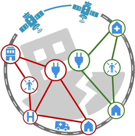
EODT4Crises
Status date: 12 March 2026
Helyx and the University of Portsmouth (UoP) have developed “Earth Observation Digital Twins (DTs) for Crises” that focus on utility and transport networks. The DTs map the vulnerability of networks to natural hazards and the damage to these systems post-event. By using earth observation imagery, our DTs support the rapid global response of humanitarian teams to crises.

FireTrack
Status date: 12 March 2026
FireTrack is a satellite-based wildfire monitoring service delivering near-real-time maps of active fire fronts and burnt areas. By processing satellite data directly in space and transmitting results within minutes, it provides emergency services and risk managers with timely, high-resolution information to support operational decision-making during ongoing wildfire events.

SAT2LEAF
Status date: 10 March 2026
SAT2LEAF (Urban and Peri-Urban Crops Monitoring through Satellite Earth Observation and Leaf-Level Data Fusion) combines satellite data from Copernicus Sentinel-2 with AI-driven plant-level diagnostics via Agrobit’s iAgro mobile app. It enables real-time monitoring and spatialization of crop health, CO₂ absorption, and diseases in urban and peri-urban farms, empowering cities and citizens with data-driven tools for sustainable food production.

BioMoss
Status date: 10 March 2026
BioMosS provides accurate and scalable biodiversity monitoring by fusing ground-truth IoT BioT sensors with satellite data. The platform delivers automated species identification and microclimate telemetry to support corporate compliance and nature restoration, achieving near-perfect precision across a 10,000+ species library.

ROAD SYSTEM Mobile App
Status date: 10 March 2026
The ROAD SYSTEM™ Mobile App transforms how cities and infrastructure experts assess cycling conditions. Leveraging AI, smartphone sensors, and high-precision GNSS data, the app enables real-time, cost-effective evaluations of cycle lanes. With its intuitive interface and ability to scale without the need for dedicated hardware, it empowers urban planners, engineers, and auditors to make data-driven decisions that enhance safety, mobility, and sustainability.

EO-VTI
Status date: 10 March 2026
EO-VTI is developing an Earth Observation–enhanced Vessel Transparency Index in collaboration with an industry partner in order to uncover deceptive and high-risk maritime activity. The project combines satellite data, AIS analytics, and explainable risk scoring to support maritime compliance, insurance, sanctions enforcement, and decarbonisation.

ÆRON
Status date: 09 March 2026
Project ÆRON is developing autonomous, remotely operated platforms for eDNA sampling in remote and extreme environments. This increases access to important biodiversity data for monitoring and managing natural environments and industry such as aquaculture.