


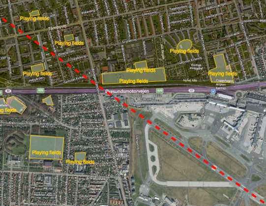
Reducing the risk of bird strikes using satellite images and Ascend’s Normalised Difference Water index software (NDWI)















BROWSE PROJECTS
Based on user needs and industry skills, the evolution of customized solutions and the establishment of innovative services is accomplished through project activities. Focusing on various thematic areas, relevant information on the project activities is provided below.

WAMMO (AMMO CCN#1)
Status date: 24 June 2020
The WAMMO project, a continuation of Ascend XYZ’s AMMO project, aims to expand the service with ground radar data. Airports will be able to visualize bird activity and identify the associated areas of interest. Radar data and correlated EO data from multiple airports will be used to produce statistical models for airports not equipped with a radar and with similar habitats.

EFFORS
Status date: 18 September 2023
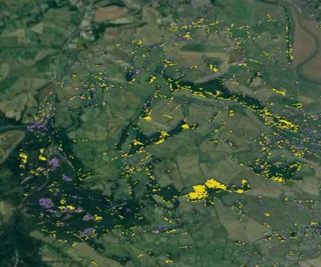
A real-time flood forecasting system has been developed and is operated at the computational centre of the Austrian national weather service GeoSphere Austria.
EFFORS brings together experts in the field of meteorology, hydrology, hydrodynamics and satellite communication. Within a coherent modelling chain, the EFFORS system couples the individual numerical models and provides relevant data about flood evolution on short time scales.
River Nexus
Status date: 16 January 2020
River Nexus is a life changer for millions of people in the river basins in developing countries. River Nexus offers climate-services based on space-technology applications and the productive use of clean renewable energy to improve the local economy. Through a single infrastructure, we cover local essential needs for sustainable development, while targeting also national and international hydro meteorological value chains.

SAVANT
Status date: 06 November 2019
SAVANT is an end-to-end analytics and insights service, generating and delivering bespoke products tailored to specific requirements of customers seeking information on the mining industry, with an initial focus on the copper mining sector.

Sun4Health
Status date: 07 January 2020
The Sun4Health demonstration project develops a ready-to-market solution by providing a comprehensive, integrated revolutionary system for the best exploitation of solar radiation benefits avoiding the healthrelated risks, according to any environmental scenario and targeted for any kind of end-user, especially for children.

ADS-B Xplore
Status date: 14 January 2020
ADS-B Xplore elaborates innovative service ideas targeting:
- Big data applications based on air traffic surveillance data
- A global communication solution accessible for every aircraft to support safety and flight route optimization
- Safe coexistence of manned and unmanned air traffic

Hawking
Status date: 17 April 2020
Hawking is a machine learning based solution for commercial growers analysing satellite imagery for better management of their crops.

Cerberus
Status date: 26 November 2019
BlackShore’s crowdsourcing platform Cerberus reinforces developing country economies utilizing satellite imagery amplifying sustainable food production while preserving the environment. This is achieved through the power of satellites, socially conscious gaming and the power of the crowd.

Saturnalia
Status date: 28 June 2018
Saturnalia leverages on Earth Observation Data to predict wine quality before bottling. Copernicus data and tailored in-situ sensors keep vineyards constantly monitored from both space and ground. Saturnalia unlocks best practices of vine management and supplies early information on next season’s fine wine. Tech-savvy wine investors and distributors rely on Saturnalia to access the most promising sales before their competitors.
DEDALOS SAT
Status date: 28 October 2019
DEDALOS is a low-cost system based on GPS for the static monitoring and early-warning of movements and deformations of critical infrastructures induced by natural (landslides, subsidence, etc.) and/or man- made impacts (excavations, extraction/injection of gases, etc.). DEDALOS SAT project aims to upgrade current system in order to provide:
- full continuity of service by adding satellite data transmission;
- improve reliability through GALILEO data processing.

Shrub Mapping
Status date: 07 April 2020
The Shrub Mapping service is intended to detect shrub management needs in young boreal forest areas. Based on Terramonitor’s Earth observation and multi-source data, the cloud service maps large forest areas, analyses and monitors the shrub situation in conifer forests and generates insights about the need for forest management duties anywhere in the world.

GroWise
Status date: 27 February 2020
GroWise will give credit providers through the use of growth models for a variety of common African crops an accurate view of the crops in the ground. It will also allow them to deliver agronomic advice, via a new app, to farmers – something which is currently lacking with small/subsistence farmers.

FertiSat
Status date: 09 January 2020
The aim of FertiSat project is to provide farmers with site-specific application maps for nitrogen fertilization of cereal crops. Since absorption of nitrogen by plants is influenced by weather and moisture conditions, those variables are taken into account when determining precise doses of the fertilizer. The service is based mainly on multispectral, high resolution satellite imagery.

RECIPE
Status date: 30 March 2020
RECIPE provides low cost 3D models of cultural assets through a COTS tool.
Input data shall be EO satellite images and photos taken by tourists, via mobile phone cameras.